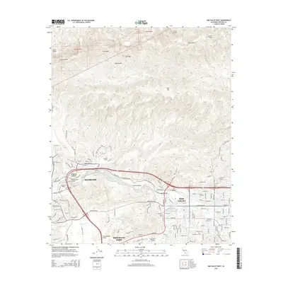
2015 Map of Simi Valley West
USGS Topo · Published 2015About this map
Moorpark and the western edge of Simi Valley occupy this landscape of dramatic relief and expanding suburban development. The transition between the high peaks of Big Mtn and Oak Ridge to the north and the alluvial plains of the Tierra Rejada Valley to the south is sharply defined by deep drainages like Alamos Canyon and Wiley Canyon. Local history is anchored at Strathearn and the Virginia Colony, while the presence of Moorpark College marks the area's mid-century educational growth. The drainage of Arroyo Simi provides a central axis for the residential corridors of the Simi Valley, contrasted by the more open, agricultural character still evident near the Arroyo Santa Rosa. Local landmarks such as Sinaloa Lake and the Assumption Cemetery provide specific points of interest for genealogists and local researchers.
Find a feature on this map
116 named features on this map. Tap any name to fly to it.
Don’t see what you’re looking for? This feature index may not catch every label — zoom into the map to look around manually.
Map Details
Editions of this 2015 Simi Valley West Map
This is the sole edition of this map. No revisions or reprints were ever made.
Other maps of this area

1900 · Triunfo Pass
USGS Topo · 1:62,500

1900 · Piru
USGS Topo · 1:62,500

1903 · Calabasas
USGS Topo · 1:62,500

1903 · Camulos
USGS Topo · 1:125,000

1903 · Santa Susana
USGS Topo · 1:62,500

1921 · Piru
USGS Topo · 1:62,500

1921 · Triunfo Pass
USGS Topo · 1:62,500

1941 · Piru
USGS Topo · 1:62,500
1941 · Santa Susana
USGS Topo · 1:62,500
1943 · Santa Susana
USGS Topo · 1:62,500