1900s (20th Century) Maps of Santa Paula, California
Explore 13 historic maps of Santa Paula from the 1900s (20th Century). These maps offer a rare glimpse into what life looked like during the 1900s — showing old roads, neighborhoods, homes, and landmarks that have changed or disappeared over time.
Whether you're researching your family's past, planning a metal detecting trip, or studying how Santa Paula's landscape evolved across the 1900s, these high-resolution maps are a powerful tool for exploring the history of this region.
- Focus on a specific era: All maps on this page are from the 1900s, giving you a focused view of this time period.
- See what’s changed: Compare century-old streets, trails, and buildings to today's modern landscape using overlays and satellite layers.
- Research with precision: Use these maps for genealogy, historical research, land use analysis, or educational projects.
- View, download, or print: Maps are fully viewable online in high resolution, and can be downloaded or printed for your own records.
Start exploring Santa Paula's history through authentic maps from the 1900s. This is your window into the past.
Santa Paula, CA maps
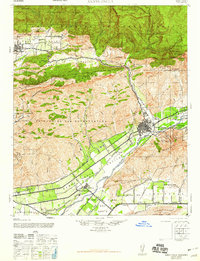
(13)- 1903 Map of Santa Paula
 1903 Santa Paula1903 Print · USGSVentura County at the turn of the century shows a landscape of deep canyons and growing rail towns before the era of modern development. Genealogists can trace family names and homesteads near Santa Paula, Nordhoff, and the Ex Mission San Buenaventura grant lands.6 unique versions available
 - 1942 Map of Santa Paula
 1942 Santa Paula1942 Print · USGSVentura County's fertile valleys and burgeoning oil industry are documented here during the early war years. Genealogists and historians can trace the rail-linked settlements of Saticoy and Santa Paula, find rural schoolhouses like Center Sch, and locate industrial sites like the Timber Canyon Oil Co.
 - 1947 Map of Santa Paula
 1947 Santa Paula1947 Print · USGSVentura County agriculture and industry meet along the Santa Clara River just after the war. Local researchers can trace the Southern Pacific rail line between Santa Paula and Saticoy, or find petroleum history at the Texaco Oil Co site.
 - 1949 Map of Los Angeles
 1949 Los Angeles1949 Print · USGSSouthern California and the South Coast appear at the onset of the post-war boom, from the Channel Islands to the Mojave Desert. Trace early aviation sites like Lockheed Air Terminal and mining history at the Redrock Quicksilver Mine and Redrover Mine.2 unique versions available
 - 1951 Map of Santa Paula Peak, 1952 Print
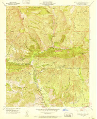 1951 Santa Paula Peak1952 Print · USGSVentura County's backcountry and the northern fringes of the Santa Clara River Valley are shown here in the early fifties, just as the regional oil industry and wilderness protections were maturing. Researchers can trace historic family holdings like Ferndale Ranch or find high-elevation landmarks such as the Santa Paula Peak Lookout and Sulphur Springs.6 unique versions available
 - 1951 Map of Santa Paula, 1952 Print
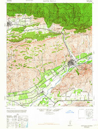
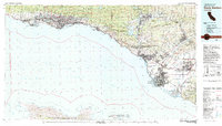
 1951 Santa Paula1952 Print · USGSSanta Paula and the Santa Clara River valley appear in the early fifties during a peak era for local citrus and oil production. Researchers can find old campus sites like Barbara Webster Sch, the Santa Paula Airport, and the industrial network of Oil Wells on South Mountain.6 unique versions available
 - 1955 Map of Los Angeles
 1955 Los Angeles1955 Print · USGSThe mid-century transformation of Southern California comes into focus as the urban sprawl of Los Angeles meets the wilderness of the Santa Monica Mountains. Researchers can trace the development of post-war suburbs alongside historic landmarks like the Santa Barbara Lighthouse and early industrial sites such as the Good Luck Mine.
 - 1959 Map of Los Angeles
 1959 Los Angeles1959 Print · USGSCoastal California and the high desert met in a period of booming growth after the war. Researchers can trace early aviation and military history at the Point Mugu Air Missile Test Ctr or locate desert mining sites like the Double Eagle Mine.3 unique versions available
 - 1964 Map of Santa Paula
 1964 Santa Paula1964 Print · USGSVentura County agriculture and industry meet in the 1940s, showing the citrus-rich Santa Clara River valley before the peak of suburban sprawl. Genealogists and historians can trace the Southern Pacific corridor through Saticoy and Ojai, locating old schools like Haines Sch and the early operations of the Texas Oil Co.
 - 1966 Map of Los Angeles
 1966 Los Angeles1966 Print · USGSSouthern California underwent a mid-century transformation as suburban grids reached the base of the San Gabriel Mountains. Researchers can trace the path of the Los Angeles Aqueduct or locate defense landmarks like Edwards Air Force Base.
 - 1975 Map of Los Angeles, 1977 Print
 1975 Los Angeles1977 Print · USGSSouthern California is captured in a period of significant growth during the mid-seventies, showing the urban sprawl from the coast to the high desert. Researchers can trace the development of the Pacific Coast Hwy and find aerospace landmarks like Edwards Air Force Base and the Flight Test Center (NASA).2 unique versions available
 - 1982 Map of Santa Barbara, 1983 Print
 1982 Santa Barbara1983 Print · USGSCoastal California in the early eighties exhibits a landscape of growing cities and massive military and academic footprints. Genealogists and historians can trace the Southern Pacific rail line through Santa Barbara or explore the boundaries of historic ranchos like Las Positas y Calera.3 unique versions available
 - 1995 Map of Santa Paula Peak, 2000 Print
 1995 Santa Paula Peak2000 Print · USGSVentura County's backcountry and northern canyons are captured here in the mid-nineties, showing the interface between the Los Padres wilderness and valley agriculture. Researchers can locate historic sites like Mupu School, Ferndale Ranch, and the Santa Paula Peak Lookout.
End of results
Showing maps 1-13 of 13
Top cities near Santa Paula
- Oxnard historical maps
- Thousand Oaks historical maps
- Ventura historical maps
- Camarillo historical maps
- Moorpark historical maps
- Port Hueneme historical maps
See more
Top neighborhoods of Santa Paula
Frequently asked questions
- What are the different types of historical maps available for Santa Paula?
- What is the oldest map of Santa Paula?
- Where can I purchase historical maps of Santa Paula for my home or office?
- Where can I download high-res historical maps of Santa Paula?
- Are there historical topographic maps available for Santa Paula?
- Is there historical aerial imagery available for Santa Paula?
- Where are historical maps of Santa Paula sourced from?