1930s Maps of Thousand Oaks, California
Explore 2 historic maps of Thousand Oaks from the 1930s. These maps offer a rare glimpse into what life looked like during the 1930s — showing old roads, neighborhoods, homes, and landmarks that have changed or disappeared over time.
Whether you're researching your family's past, planning a metal detecting trip, or studying how Thousand Oaks's landscape evolved across the 1930s, these high-resolution maps are a powerful tool for exploring the history of this region.
- Focus on a specific era: All maps on this page are from the 1930s, giving you a focused view of this time period.
- See what’s changed: Compare century-old streets, trails, and buildings to today's modern landscape using overlays and satellite layers.
- Research with precision: Use these maps for genealogy, historical research, land use analysis, or educational projects.
- View, download, or print: Maps are fully viewable online in high resolution, and can be downloaded or printed for your own records.
Start exploring Thousand Oaks's history through authentic maps from the 1930s. This is your window into the past.
Thousand Oaks, CA maps
(2)- 1932 Map of Seminole
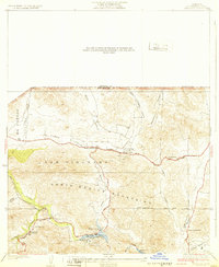 1932 Seminole1932 Print · USGSThe Santa Monica Mountains and Las Virgenes interior are captured here in the early thirties, showing the rural foothills before modern development. Trace early canyon settlements and school sites like Malibu Junction, Picture City, and Cornell Sch.2 unique versions available
 - 1932 Map of Russell Valley
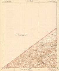 1932 Russell Valley1932 Print · USGSThe western Santa Monica Mountains and the ranch lands of the early 1930s are captured here as the region began to modernize. Researchers can trace early transport routes like Decker Road and the original Ventura Highway through Russell Valley.2 unique versions available
End of results
Showing maps 1-2 of 2
Top cities near Thousand Oaks
- Los Angeles historical maps
- Simi Valley historical maps
- Camarillo historical maps
- Moorpark historical maps
- Santa Paula historical maps
- Calabasas historical maps
See more
Top neighborhoods of Thousand Oaks
- Greenwich Village historical maps
- North Ranch historical maps
- Mountclef Village historical maps
- Triunfo Corner historical maps
- Westlake Village historical maps
- Newbury Park historical maps
See more
Frequently asked questions
- What are the different types of historical maps available for Thousand Oaks?
- What is the oldest map of Thousand Oaks?
- Where can I purchase historical maps of Thousand Oaks for my home or office?
- Where can I download high-res historical maps of Thousand Oaks?
- Are there historical topographic maps available for Thousand Oaks?
- Is there historical aerial imagery available for Thousand Oaks?
- Where are historical maps of Thousand Oaks sourced from?