1920s Maps of Thousand Oaks, California
Explore 3 historic maps of Thousand Oaks from the 1920s. These maps offer a rare glimpse into what life looked like during the 1920s — showing old roads, neighborhoods, homes, and landmarks that have changed or disappeared over time.
Whether you're researching your family's past, planning a metal detecting trip, or studying how Thousand Oaks's landscape evolved across the 1920s, these high-resolution maps are a powerful tool for exploring the history of this region.
- Focus on a specific era: All maps on this page are from the 1920s, giving you a focused view of this time period.
- See what’s changed: Compare century-old streets, trails, and buildings to today's modern landscape using overlays and satellite layers.
- Research with precision: Use these maps for genealogy, historical research, land use analysis, or educational projects.
- View, download, or print: Maps are fully viewable online in high resolution, and can be downloaded or printed for your own records.
Start exploring Thousand Oaks's history through authentic maps from the 1920s. This is your window into the past.
Thousand Oaks, CA maps
(3)- 1921 Map of Piru
 1921 Piru1921 Print · USGSThe Santa Clara River valley and southern Ventura County are shown here in the early twentieth century as the rail network expanded. Genealogists and historians can trace old property lines and rail stops at Sespe Sta, Camulos, and Bardsdale.4 unique versions available
 - 1921 Map of Triunfo Pass
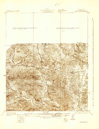
 1921 Triunfo Pass1921 Print · USGSThe coastal canyons and mountain passes of Ventura and Los Angeles counties are captured here at the turn of the century. Genealogists and historians can trace early settlements at Newbury Park and Triunfo, or follow the rugged drainage of Dume Canyon to the sea.3 unique versions available
 - 1929 Map of Vejor
 1929 Vejor1929 Print · USGSThe western edges of Los Angeles County appear as a rural landscape of canyons and country clubs during the late twenties. Trace early mountain settlements like Cornell and Picture City, or find local landmarks such as Malibu Lake and the Las Virgenes Sch.
End of results
Showing maps 1-3 of 3
Top cities near Thousand Oaks
- Los Angeles historical maps
- Simi Valley historical maps
- Camarillo historical maps
- Moorpark historical maps
- Santa Paula historical maps
- Calabasas historical maps
See more
Top neighborhoods of Thousand Oaks
- Greenwich Village historical maps
- North Ranch historical maps
- Mountclef Village historical maps
- Triunfo Corner historical maps
- Westlake Village historical maps
- Newbury Park historical maps
See more
Frequently asked questions
- What are the different types of historical maps available for Thousand Oaks?
- What is the oldest map of Thousand Oaks?
- Where can I purchase historical maps of Thousand Oaks for my home or office?
- Where can I download high-res historical maps of Thousand Oaks?
- Are there historical topographic maps available for Thousand Oaks?
- Is there historical aerial imagery available for Thousand Oaks?
- Where are historical maps of Thousand Oaks sourced from?