1990s Maps of Thousand Oaks, California
Explore 1 historic maps of Thousand Oaks from the 1990s. These maps offer a rare glimpse into what life looked like during the 1990s — showing old roads, neighborhoods, homes, and landmarks that have changed or disappeared over time.
Whether you're researching your family's past, planning a metal detecting trip, or studying how Thousand Oaks's landscape evolved across the 1990s, these high-resolution maps are a powerful tool for exploring the history of this region.
- Focus on a specific era: All maps on this page are from the 1990s, giving you a focused view of this time period.
- See what’s changed: Compare century-old streets, trails, and buildings to today's modern landscape using overlays and satellite layers.
- Research with precision: Use these maps for genealogy, historical research, land use analysis, or educational projects.
- View, download, or print: Maps are fully viewable online in high resolution, and can be downloaded or printed for your own records.
Start exploring Thousand Oaks's history through authentic maps from the 1990s. This is your window into the past.
Thousand Oaks, CA maps
(1)- 1995 Map of Point Dume, 1999 Print
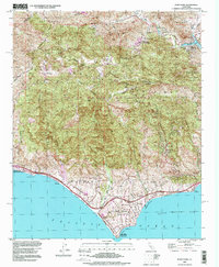 1995 Point Dume1999 Print · USGSThe Malibu coast and inland canyons appear in the mid-nineties as a mix of preserved mountain wilderness and exclusive seaside enclaves. Researchers can trace land use from the Kincaid Ranch to the early developments at Malibu Riviera and Seminole Hot Springs.
End of results
Showing maps 1-1 of 1
Top cities near Thousand Oaks
- Los Angeles historical maps
- Simi Valley historical maps
- Camarillo historical maps
- Moorpark historical maps
- Santa Paula historical maps
- Calabasas historical maps
See more
Top neighborhoods of Thousand Oaks
- Greenwich Village historical maps
- North Ranch historical maps
- Mountclef Village historical maps
- Triunfo Corner historical maps
- Westlake Village historical maps
- Newbury Park historical maps
See more
Frequently asked questions
- What are the different types of historical maps available for Thousand Oaks?
- What is the oldest map of Thousand Oaks?
- Where can I purchase historical maps of Thousand Oaks for my home or office?
- Where can I download high-res historical maps of Thousand Oaks?
- Are there historical topographic maps available for Thousand Oaks?
- Is there historical aerial imagery available for Thousand Oaks?
- Where are historical maps of Thousand Oaks sourced from?