1990s Maps of Bent County, Colorado
Explore 2 historic maps of Bent County from the 1990s. These maps offer a rare glimpse into what life looked like during the 1990s — showing old roads, neighborhoods, homes, and landmarks that have changed or disappeared over time.
Whether you're researching your family's past, planning a metal detecting trip, or studying how Bent County's landscape evolved across the 1990s, these high-resolution maps are a powerful tool for exploring the history of this region.
- Focus on a specific era: All maps on this page are from the 1990s, giving you a focused view of this time period.
- See what’s changed: Compare century-old streets, trails, and buildings to today's modern landscape using overlays and satellite layers.
- Research with precision: Use these maps for genealogy, historical research, land use analysis, or educational projects.
- View, download, or print: Maps are fully viewable online in high resolution, and can be downloaded or printed for your own records.
Start exploring Bent County's history through authentic maps from the 1990s. This is your window into the past.
Bent County, CO maps
(2)- 1996 Map of Higbee, 2000 Print
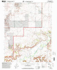 1996 Higbee2000 Print · USGSOtero County ranching and river life are documented here in the mid-1990s as the high plains meet the canyonlands. Researchers can trace local genealogy and land use through the Higbee Cem, Higbee Valley Sch, and the winding Purgatoire River.
 - 1996 Map of Thompson Arroyo, 2000 Print
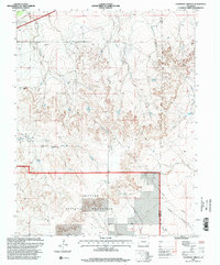 1996 Thompson Arroyo2000 Print · USGSSoutheastern Colorado prairie lands appear here in the mid-nineties, showing the intersection of conservation and cattle country. Researchers can trace the water-scarce landscape through Vandiver Canal, Circle T Waters Spring, and the grazing lands of Comanche National Grassland.
End of results
Showing maps 1-2 of 2
Top cities of Bent County
Frequently asked questions
- What are the different types of historical maps available for Bent County?
- What is the oldest map of Bent County?
- Where can I purchase historical maps of Bent County for my home or office?
- Where can I download high-res historical maps of Bent County?
- Are there historical topographic maps available for Bent County?
- Is there historical aerial imagery available for Bent County?
- Where are historical maps of Bent County sourced from?