1970s Maps of Bent County, Colorado
Explore 11 historic maps of Bent County from the 1970s. These maps offer a rare glimpse into what life looked like during the 1970s — showing old roads, neighborhoods, homes, and landmarks that have changed or disappeared over time.
Whether you're researching your family's past, planning a metal detecting trip, or studying how Bent County's landscape evolved across the 1970s, these high-resolution maps are a powerful tool for exploring the history of this region.
- Focus on a specific era: All maps on this page are from the 1970s, giving you a focused view of this time period.
- See what’s changed: Compare century-old streets, trails, and buildings to today's modern landscape using overlays and satellite layers.
- Research with precision: Use these maps for genealogy, historical research, land use analysis, or educational projects.
- View, download, or print: Maps are fully viewable online in high resolution, and can be downloaded or printed for your own records.
Start exploring Bent County's history through authentic maps from the 1970s. This is your window into the past.
Bent County, CO maps
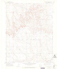
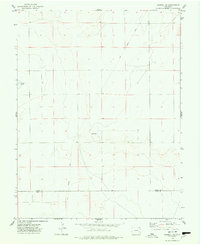
(11)- 1971 Map of Ninaview, 1973 Print
 1971 Ninaview1973 Print · USGSThe High Plains of southeastern Colorado in the early seventies reveal a landscape of isolated ranching outposts and dramatic geology. Trace family ties to the Ninaview area or study local landmarks like Pine Hill School and the Devils Rocking Chair.
 - 1971 Map of Floating W Ranch, 1973 Print
 1971 Floating W Ranch1973 Print · USGSSoutheast Colorado ranching country is captured here in the early seventies, detailing the rugged drainages along the Bent and Baca county line. Researchers can locate the Floating W Ranch, the Prairie Hill School, and early transport routes like the JEEP TRAIL.2 unique versions available
 - 1971 Map of Pipe Spring, 1974 Print
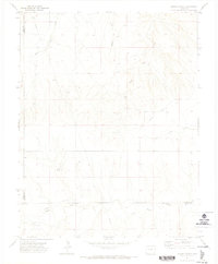
 1971 Pipe Spring1974 Print · USGSSoutheastern Colorado rangeland is captured here in the early 1970s, as the county line divides this prairie landscape. Researchers can locate vital water sources like Pipe Spring and Thompson Spring and trace the winding course of Caddoa Creek.
 - 1971 Map of Clay Ranch, 1974 Print
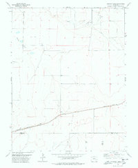
 1971 Clay Ranch1974 Print · USGSSoutheastern Colorado ranching country is documented here in the early 1970s, at the tri-county junction of Bent, Las Animas, and Baca. Trace the historic Atchison Topeka and Santa Fe rail line as it passes near Ruxton and Clay Ranch.
 - 1971 Map of Hasser Ranch, 1974 Print
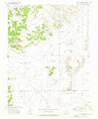
 1971 Hasser Ranch1974 Print · USGSIn the early 1970s, this corner of Southeastern Colorado remained a landscape of isolated ranching outposts and historic wagon routes. Genealogists and historians can trace the Santa Fe Trail as it cuts past Hasser Ranch and Two Butte Creek.
 - 1972 Map of Rock Canyon, 1976 Print
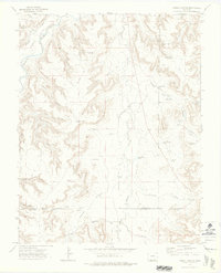
 1972 Rock Canyon1976 Print · USGSSoutheast Colorado ranching country in the early seventies centered on the rugged drainages of the Bent and Las Animas county line. Researchers can trace family landmarks like the Pruett Cem, England Spring, and several named water works including East Parsons Windmill.
 - 1972 Map of Corbin Canyon, 1976 Print
 1972 Corbin Canyon1976 Print · USGSSoutheastern Colorado ranching country is mapped here in the early 1970s at the intersection of Otero, Bent, and Las Animas counties. Researchers can trace remote water sources and family landmarks such as Anstine Windmill, Harbordale Pond, and the Purgatoire River.2 unique versions available
 - 1974 Map of Haswell SE, 1978 Print
 1974 Haswell SE1978 Print · USGSThe eastern Colorado plains at the boundary of Kiowa and Bent counties come into focus in the 1970s. Trace the path of the Old Railroad Grade past Potters Lake and the central Radio Tower to see how this landscape was used.
 - 1978 Map of Long Lake
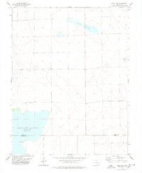 1978 Long Lake1978 Print · USGSThe Colorado plains at the Kiowa and Bent county line are documented here during the late 1970s. Local researchers can trace the shoreline of Adobe Creek Reservoir (Blue Lake) and find points of interest like Potters Lake and a remote Drill Hole.
 - 1978 Map of Arlington
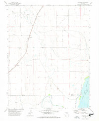 1978 Arlington1978 Print · USGSArlington was a rail-side hub on the Colorado plains during the late seventies, defined by its complex irrigation networks. Genealogists and historians can trace the Arlington Cem, the Missouri Pacific railroad, and the massive Adobe Creek Reservoir.
 - 1978 Map of Houston Lakes
 1978 Houston Lakes1978 Print · USGSSoutheastern Colorado's high plains are mapped during the 1970s, showing a landscape defined by ranching and rail. Genealogists can trace the settlement at Heath and the Missouri Pacific railroad as it crosses the Kiowa and Otero county lines.2 unique versions available
End of results
Showing maps 1-11 of 11
Top cities of Bent County
Frequently asked questions
- What are the different types of historical maps available for Bent County?
- What is the oldest map of Bent County?
- Where can I purchase historical maps of Bent County for my home or office?
- Where can I download high-res historical maps of Bent County?
- Are there historical topographic maps available for Bent County?
- Is there historical aerial imagery available for Bent County?
- Where are historical maps of Bent County sourced from?