1900s (20th Century) Maps of Platoro, Colorado
Explore 11 historic maps of Platoro from the 1900s (20th Century). These maps offer a rare glimpse into what life looked like during the 1900s — showing old roads, neighborhoods, homes, and landmarks that have changed or disappeared over time.
Whether you're researching your family's past, planning a metal detecting trip, or studying how Platoro's landscape evolved across the 1900s, these high-resolution maps are a powerful tool for exploring the history of this region.
- Focus on a specific era: All maps on this page are from the 1900s, giving you a focused view of this time period.
- See what’s changed: Compare century-old streets, trails, and buildings to today's modern landscape using overlays and satellite layers.
- Research with precision: Use these maps for genealogy, historical research, land use analysis, or educational projects.
- View, download, or print: Maps are fully viewable online in high resolution, and can be downloaded or printed for your own records.
Start exploring Platoro's history through authentic maps from the 1900s. This is your window into the past.
Platoro, CO maps
(11)- 1913 Map of Summitville, 1962 Print
 1913 Summitville1962 Print · USGSThe high San Juan Mountains at the turn of the century are captured here, from the gold-mining district at Summitville to the ranchlands of the Navajo River valley. Genealogists and historians can trace early school sites like Blanco School and working mines including the Asiatic Mine and Forest King Mine.
 - 1915 Map of Summitville
 1915 Summitville1915 Print · USGSSouthern Colorado mining and timber operations are captured here during the early twentieth century. Researchers can trace remote mining claims like the Asiatic Mine, mountain schools such as Blanco School, and the path of the Logging RR.4 unique versions available
 - 1945 Map of Durango
 1945 Durango1945 Print · USGSSouthwest Colorado and Northern New Mexico at mid-century are defined by the high peaks of the San Juan Range and the tribal lands of the Southern Ute. Genealogists and historians can trace the paths of the D & R G W RR and locate local landmarks like Animas City and the Blanco Basin School.3 unique versions available
 - 1953 Map of Durango, 1963 Print
 1953 Durango1963 Print · USGSThe high peaks of the San Juan Mountains and the Colorado mining country are shown here as they appeared in the early fifties. Genealogists and local historians can trace the rail lines of the D & R G W RR and locate historic mining camps like Silverton, Ouray, and Old Ophir.
 - 1954 Map of Durango
 1954 Durango1954 Print · USGSSouthern Colorado in the mid-1950s was defined by high-altitude mining towns and the expansion of water storage in the San Luis Valley. Trace the narrow-gauge Denver & Rio Grande Western RR as it connects Durango to mountain outposts like Silverton and Creede.2 unique versions available
 - 1961 Map of Durango
 1961 Durango1961 Print · USGSThe high San Juan country in the early sixties is shown here as a network of historic mining towns and early reservoir projects. Genealogists and researchers can trace the Denver & Rio Grande Western RR as it connects Durango, Silverton, and Arboles.
 - 1963 Map of Durango
 1963 Durango1963 Print · USGSThe San Juan Mountains and San Luis Valley are captured here in the early 1950s as mining, rail, and tribal lands shaped the region. Researchers can trace the Denver & Rio Grande Western RR through high-country towns like Telluride and Silverton, or locate landmarks such as the Asiatic Mine.
 - 1966 Map of Durango
 1966 Durango1966 Print · USGSSouthwestern Colorado and the New Mexico borderlands are shown here in the mid-1960s, a time when the narrow-gauge rail network still tied the high peaks to the valley floor. Researchers can trace the Denver & Rio Grande Western Railroad between settlements like Silverton, Antonito, and Pagosa Springs.2 unique versions available
 - 1967 Map of Platoro, 1969 Print
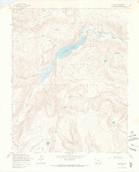 1967 Platoro1969 Print · USGSThe high-country settlement of Platoro is captured here during the 1960s, surrounded by the rugged peaks and alpine lakes of the Rio Grande National Forest. Trace the legacy of mountain mining at the Mammoth Revenue Mine or locate historic backcountry routes like the Continental Divide Trail and Stunner Pass.3 unique versions available
 - 1967 Map of Platoro, 1972 Print
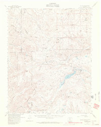 1967 Platoro1972 Print · USGSThe high San Juan peaks and mining districts of Southern Colorado come into focus in the late 1960s. Genealogists and historians can locate the Mammoth Revenue Mine, the remote Summitville settlement, and early forest outposts like Elwood Guard Sta.2 unique versions available
 - 1985 Map of Antonito
 1985 Antonito1985 Print · USGSThe Colorado and New Mexico borderlands come into focus during the mid-eighties as the high peaks of the San Juans meet the San Luis Valley. Trace the winding Cumbres and Toltec Scenic Railroad or locate historical mining sites like the Black Diamond Mine and Summitville.2 unique versions available
End of results
Showing maps 1-11 of 11
Frequently asked questions
- What are the different types of historical maps available for Platoro?
- What is the oldest map of Platoro?
- Where can I purchase historical maps of Platoro for my home or office?
- Where can I download high-res historical maps of Platoro?
- Are there historical topographic maps available for Platoro?
- Is there historical aerial imagery available for Platoro?
- Where are historical maps of Platoro sourced from?