1990s Maps of Costilla County, Colorado
Explore 4 historic maps of Costilla County from the 1990s. These maps offer a rare glimpse into what life looked like during the 1990s — showing old roads, neighborhoods, homes, and landmarks that have changed or disappeared over time.
Whether you're researching your family's past, planning a metal detecting trip, or studying how Costilla County's landscape evolved across the 1990s, these high-resolution maps are a powerful tool for exploring the history of this region.
- Focus on a specific era: All maps on this page are from the 1990s, giving you a focused view of this time period.
- See what’s changed: Compare century-old streets, trails, and buildings to today's modern landscape using overlays and satellite layers.
- Research with precision: Use these maps for genealogy, historical research, land use analysis, or educational projects.
- View, download, or print: Maps are fully viewable online in high resolution, and can be downloaded or printed for your own records.
Start exploring Costilla County's history through authentic maps from the 1990s. This is your window into the past.
Costilla County, CO maps
(4)- 1994 Map of Trinchera Peak, 1998 Print
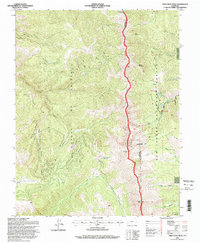 1994 Trinchera Peak1998 Print · USGSThe Sangre De Cristo Range stands as a massive barrier in the 1990s, where high-altitude peaks meet the edge of the Cuchara Valley. Genealogists and hikers can trace the Indian Creek Trail, locate remote Mine sites, and explore the geography of the Cuchara Valley Ski Area.
 - 1994 Map of El Valle Creek, 1998 Print
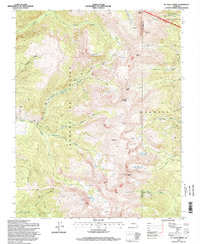 1994 El Valle Creek1998 Print · USGSThe high peaks of the Sangre de Cristos are captured here in the 1990s, where the county line divides Costilla and Las Animas. Backcountry travelers can trace the Whiskey Pass Road toward Whiskey Pass or locate remote alpine waters like Lost Lake and Strawberry Lake.
 - 1994 Map of Mc Carty Park, 1998 Print
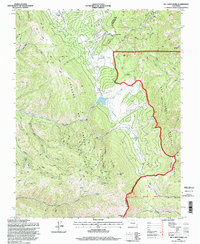 1994 Mc Carty Park1998 Print · USGSThe high peaks of the Sangre de Cristo Range and the sprawling San Isabel National Forest define this mid-nineties topography. Researchers can trace remote ranching outposts like McCarty Cow Camp and the winding paths through Veta Pass and American Canyon.
 - 1995 Map of The Wall, 1997 Print
 1995 The Wall1997 Print · USGSNorthern New Mexico and the Colorado borderland are shown in the mid-nineties, featuring the intersection of historic land grants and national forest. Researchers can trace remote mountain outposts like Bernal Cabin, the Van Diest Mine, and landmarks like Vermejo Peak.
End of results
Showing maps 1-4 of 4
Top cities of Costilla County
Frequently asked questions
- What are the different types of historical maps available for Costilla County?
- What is the oldest map of Costilla County?
- Where can I purchase historical maps of Costilla County for my home or office?
- Where can I download high-res historical maps of Costilla County?
- Are there historical topographic maps available for Costilla County?
- Is there historical aerial imagery available for Costilla County?
- Where are historical maps of Costilla County sourced from?