2000-2009 Maps of Delta County, Colorado
Explore 7 historic maps of Delta County from 2000-2009. These maps offer a rare glimpse into what life looked like during the 2000s — showing old roads, neighborhoods, homes, and landmarks that have changed or disappeared over time.
Whether you're researching your family's past, planning a metal detecting trip, or studying how Delta County's landscape evolved across the 2000s, these high-resolution maps are a powerful tool for exploring the history of this region.
- Focus on a specific era: All maps on this page are from the 2000s, giving you a focused view of this time period.
- See what’s changed: Compare century-old streets, trails, and buildings to today's modern landscape using overlays and satellite layers.
- Research with precision: Use these maps for genealogy, historical research, land use analysis, or educational projects.
- View, download, or print: Maps are fully viewable online in high resolution, and can be downloaded or printed for your own records.
Start exploring Delta County's history through authentic maps from the 2000s. This is your window into the past.
Delta County, CO maps
(7)- 2001 Map of Bowie, 2004 Print
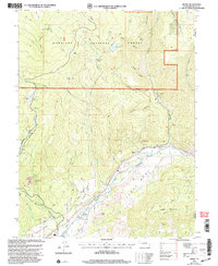 2001 Bowie2004 Print · USGSThe coal and water networks of Delta County are in full view around the turn of the millennium. Trace the industrial landscape of the Bowie Mine and Juanita Junction, or locate family-named landmarks like Morrell Cow Camp and Stevens Gulch.
 - 2001 Map of Electric Mountain, 2004 Print
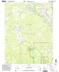 2001 Electric Mountain2004 Print · USGSThe high Colorado backcountry of the Gunnison and Delta county line is shown here at the turn of the millennium. Researchers can trace ranching history at Norells Bell Ranch, follow the Terror Trail, or locate the West Muddy Ranger Sta.
 - 2001 Map of Somerset, 2004 Print
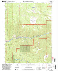 2001 Somerset2004 Print · USGSIn the Gunnison River valley at the turn of the millennium, this area was a busy center for coal production and high-country ranching. Researchers can trace the footprint of the Kaiser Mine, the path of the Fire Mountain Canal, and remote sites like Dry Fork Cow Camp.
 - 2001 Map of Bull Mountain, 2004 Print
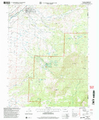
 2001 Bull Mountain2004 Print · USGSHigh-country ranching and forest management define this Colorado landscape at the turn of the millennium. Researchers can trace seasonal land use through isolated sites like Cockroft Cow Camp, Patterson Place, and Hotchkiss Sheep Camp.
 - 2001 Map of Minnesota Pass, 2004 Print
 2001 Minnesota Pass2004 Print · USGSThe West Elk Mountains at the turn of the millennium are shown here in detail, from the heights of Mount Gunnison to the waters of Beaver Reservoir. Researchers can trace old high-country routes like the Through Line Trail and locate seasonal landmarks such as Minnesota Cow Camp.
 - 2001 Map of Paonia, 2004 Print
 2001 Paonia2004 Print · USGSPaonia and the surrounding mesas at the turn of the millennium show a landscape defined by high-altitude agriculture and the West Elk wilderness. Genealogists can locate family landmarks like Bethlehem Cem, the Stewart Mesa Sch, and the namesake peaks of Mount Lamborn and Landsend Peak.
 - 2001 Map of Crawford, 2004 Print
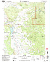 2001 Crawford2004 Print · USGSCrawford and the surrounding Delta County mesas are shown here at the turn of the millennium, just after the Crawford Reservoir was established for recreation. Researchers can trace irrigation history along the Clipper Ditch or locate family sites near Maher and Needle Rock.2 unique versions available
End of results
Showing maps 1-7 of 7
Top cities of Delta County
- Delta historical maps
- Orchard City historical maps
- Cedaredge historical maps
- Paonia historical maps
- Hotchkiss historical maps
- Crawford historical maps
Frequently asked questions
- What are the different types of historical maps available for Delta County?
- What is the oldest map of Delta County?
- Where can I purchase historical maps of Delta County for my home or office?
- Where can I download high-res historical maps of Delta County?
- Are there historical topographic maps available for Delta County?
- Is there historical aerial imagery available for Delta County?
- Where are historical maps of Delta County sourced from?