1920s Maps of Eagle County, Colorado
Explore 2 historic maps of Eagle County from the 1920s. These maps offer a rare glimpse into what life looked like during the 1920s — showing old roads, neighborhoods, homes, and landmarks that have changed or disappeared over time.
Whether you're researching your family's past, planning a metal detecting trip, or studying how Eagle County's landscape evolved across the 1920s, these high-resolution maps are a powerful tool for exploring the history of this region.
- Focus on a specific era: All maps on this page are from the 1920s, giving you a focused view of this time period.
- See what’s changed: Compare century-old streets, trails, and buildings to today's modern landscape using overlays and satellite layers.
- Research with precision: Use these maps for genealogy, historical research, land use analysis, or educational projects.
- View, download, or print: Maps are fully viewable online in high resolution, and can be downloaded or printed for your own records.
Start exploring Eagle County's history through authentic maps from the 1920s. This is your window into the past.
Eagle County, CO maps
(2)- 1927 Map of Glenwood Springs, 1956 Print
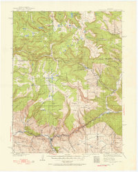 1927 Glenwood Springs1956 Print · USGSGarfield County’s mountain interior comes to life in the 1920s, showing the high-country settlements and early forest service infrastructure across the Colorado River valley. Genealogists can trace family footprints at Sweetwater Lake Sch, the Shoshone Power Plant, and remote outposts like Hip Roof Cabin.3 unique versions available
 - 1929 Map of Dillon, 1955 Print
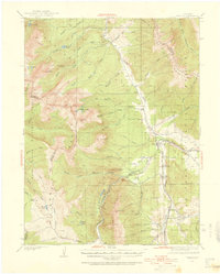 1929 Dillon1955 Print · USGSIn the late 1920s, the Blue River valley was a high-country network of rail stops and mining camps before the landscape was changed by major dam projects. Genealogists and historians can trace the early footprints of Dillon, Frisco, and the Colorado and Southern railroad line.2 unique versions available
End of results
Showing maps 1-2 of 2
Top cities of Eagle County
- Edwards historical maps
- Gypsum historical maps
- Eagle historical maps
- Avon historical maps
- Vail historical maps
- El Jebel historical maps
See more
Frequently asked questions
- What are the different types of historical maps available for Eagle County?
- What is the oldest map of Eagle County?
- Where can I purchase historical maps of Eagle County for my home or office?
- Where can I download high-res historical maps of Eagle County?
- Are there historical topographic maps available for Eagle County?
- Is there historical aerial imagery available for Eagle County?
- Where are historical maps of Eagle County sourced from?