1930s Maps of Eagle County, Colorado
Explore 6 historic maps of Eagle County from the 1930s. These maps offer a rare glimpse into what life looked like during the 1930s — showing old roads, neighborhoods, homes, and landmarks that have changed or disappeared over time.
Whether you're researching your family's past, planning a metal detecting trip, or studying how Eagle County's landscape evolved across the 1930s, these high-resolution maps are a powerful tool for exploring the history of this region.
- Focus on a specific era: All maps on this page are from the 1930s, giving you a focused view of this time period.
- See what’s changed: Compare century-old streets, trails, and buildings to today's modern landscape using overlays and satellite layers.
- Research with precision: Use these maps for genealogy, historical research, land use analysis, or educational projects.
- View, download, or print: Maps are fully viewable online in high resolution, and can be downloaded or printed for your own records.
Start exploring Eagle County's history through authentic maps from the 1930s. This is your window into the past.
Eagle County, CO maps
(6)- 1930 Map of Glenwood Springs
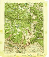 1930 Glenwood Springs1930 Print · USGSGlenwood Springs and the Colorado River corridor are captured here during the late prohibition era, showing the region's transition into a center for power and rail transport. Researchers can trace the Denver and Rio Grande Western Railroad to Dotsero or find remote outposts like Hip Roof Cabin and Transfer Springs Ranger Sta.4 unique versions available
 - 1933 Map of Mt. Powell
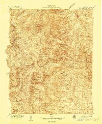
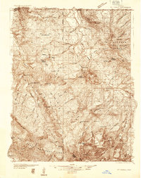 1933 Mt. Powell1933 Print · USGSThe Colorado high country in the early thirties reveals a landscape of isolated mountain homesteads and remote federal forest lands. Genealogists and local historians can trace family locations like the Noonen Ranch or locate early rural schools including Upper Sheephorn Sch and Lakeside Sch.5 unique versions available
 - 1934 Map of Climax
 1934 Climax1934 Print · USGSThe Colorado high country in the mid-1930s reveals a landscape of industrial mining and high-altitude transport. Trace the routes of the Colorado and Southern RR or locate the historic mining district of Quartzville and the London Mine.
 - 1934 Map of Minturn
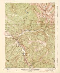 1934 Minturn1934 Print · USGSThe mountain corridors of Eagle County were defined by mining and the railroad during the early nineteen-thirties. You can trace the industrial landscape of the Eagle River through settlements like Gilman, the remote Bells Camp, and the high-altitude Liberty Mine.5 unique versions available
 - 1934 Map of Dillon
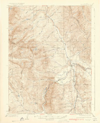 1934 Dillon1934 Print · USGSDillon and the surrounding Blue River Valley are shown here in the mid-1930s before the valley was flooded for reservoir construction. Genealogists and historians can trace the original locations of Dillon, the Dickey Ranger Sta, and mining sites like the Boss Mine.3 unique versions available
 - 1938 Map of Mt. Lincoln
 1938 Mt. Lincoln1938 Print · USGSSummit and Park counties are captured here in the late 1930s, documenting the high-altitude mining landscape of the Tenmile Range. Researchers can trace the early footprints of Alma, the mining sites at Kokomo and London, and historic routes over Mosquito Pass.7 unique versions available
End of results
Showing maps 1-6 of 6
Top cities of Eagle County
- Edwards historical maps
- Gypsum historical maps
- Eagle historical maps
- Avon historical maps
- Vail historical maps
- El Jebel historical maps
See more
Frequently asked questions
- What are the different types of historical maps available for Eagle County?
- What is the oldest map of Eagle County?
- Where can I purchase historical maps of Eagle County for my home or office?
- Where can I download high-res historical maps of Eagle County?
- Are there historical topographic maps available for Eagle County?
- Is there historical aerial imagery available for Eagle County?
- Where are historical maps of Eagle County sourced from?