1940s Maps of Eagle County, Colorado
Explore 4 historic maps of Eagle County from the 1940s. These maps offer a rare glimpse into what life looked like during the 1940s — showing old roads, neighborhoods, homes, and landmarks that have changed or disappeared over time.
Whether you're researching your family's past, planning a metal detecting trip, or studying how Eagle County's landscape evolved across the 1940s, these high-resolution maps are a powerful tool for exploring the history of this region.
- Focus on a specific era: All maps on this page are from the 1940s, giving you a focused view of this time period.
- See what’s changed: Compare century-old streets, trails, and buildings to today's modern landscape using overlays and satellite layers.
- Research with precision: Use these maps for genealogy, historical research, land use analysis, or educational projects.
- View, download, or print: Maps are fully viewable online in high resolution, and can be downloaded or printed for your own records.
Start exploring Eagle County's history through authentic maps from the 1940s. This is your window into the past.
Eagle County, CO maps
(4)- 1940 Map of Mount Powell
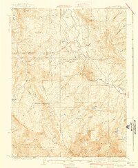 1940 Mount Powell1940 Print · USGSThe high peaks of the Gore Range and the Blue River valley are shown here during the late 1930s. Researchers can locate remote homesteads and schools such as Abbet Place, Smith Ranch, and the Hillcrest Sch among the alpine lakes.3 unique versions available
 - 1942 Map of Leadville, 1943 Print
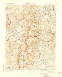
 1942 Leadville1943 Print · USGSHigh in the Rockies during the early war years, this area served as a critical hub for military training and mining operations. Trace the rail lines of the Denver and Rio Grande Western RR and find local landmarks like the U. S. Fish Hatchery or the Adelaide mine.
 - 1945 Map of Mount Lincoln
 1945 Mount Lincoln1945 Print · USGSBreckenridge and the surrounding mining districts were still active industrial hubs when this survey was updated in the mid-1940s. Researchers can trace historic claims and mineral landmarks such as USLM No 16 and the remote high-altitude site of Climax.2 unique versions available
 - 1949 Map of Holy Cross, 1955 Print
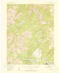 1949 Holy Cross1955 Print · USGSThe Eagle River valley and the high-altitude terrain of the Sawatch Range are captured here just after the war. You can trace the military history of Camp Hale and find old mining claims like the Matchless Mine or the remote Holy Cross City.7 unique versions available
End of results
Showing maps 1-4 of 4
Top cities of Eagle County
- Edwards historical maps
- Gypsum historical maps
- Eagle historical maps
- Avon historical maps
- Vail historical maps
- El Jebel historical maps
See more
Frequently asked questions
- What are the different types of historical maps available for Eagle County?
- What is the oldest map of Eagle County?
- Where can I purchase historical maps of Eagle County for my home or office?
- Where can I download high-res historical maps of Eagle County?
- Are there historical topographic maps available for Eagle County?
- Is there historical aerial imagery available for Eagle County?
- Where are historical maps of Eagle County sourced from?