1970s Maps of Colorado Springs, Colorado
Explore 1 historic maps of Colorado Springs from the 1970s. These maps offer a rare glimpse into what life looked like during the 1970s — showing old roads, neighborhoods, homes, and landmarks that have changed or disappeared over time.
Whether you're researching your family's past, planning a metal detecting trip, or studying how Colorado Springs's landscape evolved across the 1970s, these high-resolution maps are a powerful tool for exploring the history of this region.
- Focus on a specific era: All maps on this page are from the 1970s, giving you a focused view of this time period.
- See what’s changed: Compare century-old streets, trails, and buildings to today's modern landscape using overlays and satellite layers.
- Research with precision: Use these maps for genealogy, historical research, land use analysis, or educational projects.
- View, download, or print: Maps are fully viewable online in high resolution, and can be downloaded or printed for your own records.
Start exploring Colorado Springs's history through authentic maps from the 1970s. This is your window into the past.
Colorado Springs, CO maps
(1)- 1975 Map of Monument, 1978 Print
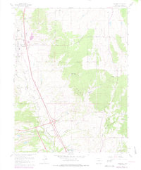 1975 Monument1978 Print · USGSThe foothills north of Colorado Springs are captured in the mid-seventies, showing the intersection of military expansion and rural ranching. Genealogists and historians can trace family properties like Hardesty Ranch alongside the Air Force Academy and the historic Mt Herman Grange.
End of results
Showing maps 1-1 of 1
Top cities near Colorado Springs
- Fountain historical maps
- Manitou Springs historical maps
- Monument historical maps
- Palmer Lake historical maps
Top neighborhoods of Colorado Springs
- Stratton Meadows historical maps
- Broadmoor historical maps
- Kelker historical maps
- Knob Hill historical maps
- Pikeview historical maps
- Roswell historical maps
See more
Frequently asked questions
- What are the different types of historical maps available for Colorado Springs?
- What is the oldest map of Colorado Springs?
- Where can I purchase historical maps of Colorado Springs for my home or office?
- Where can I download high-res historical maps of Colorado Springs?
- Are there historical topographic maps available for Colorado Springs?
- Is there historical aerial imagery available for Colorado Springs?
- Where are historical maps of Colorado Springs sourced from?