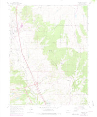
1975 Map of Monument
USGS Topo · Published 1978About this map
United States Air Force Academy grounds dominate the southern reaches of this mid-1970s survey, illustrating the military institution's expansive footprint alongside the northern Colorado Springs foothills. The landscape is a transition between the high plains and the Pike National Forest, characterized by a series of north-south drainage networks including Dirty Woman Creek and Monument Creek. Settlement patterns cluster around the established towns of Palmer Lake and Monument, while the surrounding territory is defined by large ranching properties such as Misty Acres Ranch, Hardesty Ranch, and Flying Horse Ranch. Transportation is anchored by the Denver and Rio Grande Western Railroad, while the map also preserves the paths of an Old Railroad Grade and the Atchison Topeka and Santa Fe Railroad Grade, marking the evolution of the region's rail corridors.
Find a feature on this map
36 named features on this map. Tap any name to fly to it.
Don’t see what you’re looking for? This feature index may not catch every label — zoom into the map to look around manually.
Map Details
Editions of this 1975 Monument Map
This is the sole edition of this map. No revisions or reprints were ever made.
Other maps of this area

1893 · Colorado Springs
USGS Topo · 1:125,000

1894 · Castle Rock
USGS Topo · 1:125,000

1909 · Colorado Springs
USGS Topo · 1:125,000

1913 · Castle Rock
USGS Topo · 1:125,000

1940 · Elbert
USGS Topo · 1:62,500

1942 · Colorado Springs
USGS Topo · 1:125,000

1944 · Elbert
USGS Topo · 1:62,500

1948 · Colorado Springs
USGS Topo · 1:62,500

1948 · Pikeview
USGS Topo · 1:24,000

1948 · Cascade
USGS Topo · 1:24,000