
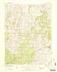
1940 Map of Elbert
USGS Topo · Published 1956About this map
Elbert and Eastonville serve as the primary hubs in this high-plains landscape where the edge of the Black Forest meets the drainage basins of the Palmer Divide. The map illustrates a transitional rural economy defined by cattle ranching and a dense network of country schools, including Cedar Grove Sch, Sidney Sch, and Elton Sch, which anchored the scattered homesteads of the era. To the south, the Chicago Rock Island & Pacific railroad cuts through the terrain near the H-2 Ranch and Ayer Ranch, providing a vital link for the region's agricultural output.
Find a feature on this map
49 named features on this map. Tap any name to fly to it.
Don’t see what you’re looking for? This feature index may not catch every label — zoom into the map to look around manually.
Map Details
Editions of this 1940 Elbert Map
2 editions found
Other maps of this area

1893 · Big Springs
USGS Topo · 1:125,000

1893 · Colorado Springs
USGS Topo · 1:125,000

1894 · Castle Rock
USGS Topo · 1:125,000

1909 · Colorado Springs
USGS Topo · 1:125,000

1913 · Castle Rock
USGS Topo · 1:125,000

1939 · Elizabeth
USGS Topo · 1:62,500

1940 · Castle Rock
USGS Topo · 1:62,500

1942 · Colorado Springs
USGS Topo · 1:125,000

1944 · Elbert
USGS Topo · 1:62,500

1945 · Castle Rock
USGS Topo · 1:62,500