1990s Maps of Colorado Springs, Colorado
Explore 2 historic maps of Colorado Springs from the 1990s. These maps offer a rare glimpse into what life looked like during the 1990s — showing old roads, neighborhoods, homes, and landmarks that have changed or disappeared over time.
Whether you're researching your family's past, planning a metal detecting trip, or studying how Colorado Springs's landscape evolved across the 1990s, these high-resolution maps are a powerful tool for exploring the history of this region.
- Focus on a specific era: All maps on this page are from the 1990s, giving you a focused view of this time period.
- See what’s changed: Compare century-old streets, trails, and buildings to today's modern landscape using overlays and satellite layers.
- Research with precision: Use these maps for genealogy, historical research, land use analysis, or educational projects.
- View, download, or print: Maps are fully viewable online in high resolution, and can be downloaded or printed for your own records.
Start exploring Colorado Springs's history through authentic maps from the 1990s. This is your window into the past.
Colorado Springs, CO maps
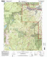
(2)- 1994 Map of Cascade, 1998 Print
 1994 Cascade1998 Print · USGSThe Rampart Range rises above the Colorado Springs fringe in the 1990s, where high-altitude reservoirs meet military and recreational land. Genealogists and hikers can trace the mountain communities of Cascade and Chipita Park or the iconic terrain of the Garden of the Gods.
 - 1994 Map of Manitou Springs, 2001 Print
 1994 Manitou Springs2001 Print · USGSManitou Springs sat at a junction of rail and trail in the mid-1990s, serving as a hub for mountain travel and water engineering. Trace the path of the Manitou and Pikes Peak Railway or locate the site of Nelson Camp near Mount Rosa.
End of results
Showing maps 1-2 of 2
Top cities near Colorado Springs
- Fountain historical maps
- Manitou Springs historical maps
- Monument historical maps
- Palmer Lake historical maps
Top neighborhoods of Colorado Springs
- Stratton Meadows historical maps
- Broadmoor historical maps
- Kelker historical maps
- Knob Hill historical maps
- Pikeview historical maps
- Roswell historical maps
See more
Frequently asked questions
- What are the different types of historical maps available for Colorado Springs?
- What is the oldest map of Colorado Springs?
- Where can I purchase historical maps of Colorado Springs for my home or office?
- Where can I download high-res historical maps of Colorado Springs?
- Are there historical topographic maps available for Colorado Springs?
- Is there historical aerial imagery available for Colorado Springs?
- Where are historical maps of Colorado Springs sourced from?