1980s Maps of Huerfano County, Colorado
Explore 7 historic maps of Huerfano County from the 1980s. These maps offer a rare glimpse into what life looked like during the 1980s — showing old roads, neighborhoods, homes, and landmarks that have changed or disappeared over time.
Whether you're researching your family's past, planning a metal detecting trip, or studying how Huerfano County's landscape evolved across the 1980s, these high-resolution maps are a powerful tool for exploring the history of this region.
- Focus on a specific era: All maps on this page are from the 1980s, giving you a focused view of this time period.
- See what’s changed: Compare century-old streets, trails, and buildings to today's modern landscape using overlays and satellite layers.
- Research with precision: Use these maps for genealogy, historical research, land use analysis, or educational projects.
- View, download, or print: Maps are fully viewable online in high resolution, and can be downloaded or printed for your own records.
Start exploring Huerfano County's history through authentic maps from the 1980s. This is your window into the past.
Huerfano County, CO maps
(7)- 1982 Map of Walsenburg
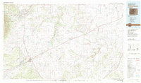 1982 Walsenburg1982 Print · USGSThe Huerfano valley in the early eighties shows a landscape of mining camps and cattle country. Genealogists can trace family names at Masonic Cem or locate old industrial sites like the Pacific Mine and the rail junction at Walsenburg.
 - 1982 Map of Trinidad, 1983 Print
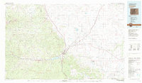 1982 Trinidad1983 Print · USGSSouthern Colorado's high desert and mesas are captured here in the early 1980s, centered on the historic rail hub of Trinidad. Researchers can trace the industrial and social footprints of Ludlow, Cokedale, and traditional settlements like Velasquez Plaza.
 - 1982 Map of Blanca Peak, 1983 Print
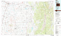
 1982 Blanca Peak1983 Print · USGSThe Sangre de Cristo range reaches its highest elevations in the early 1980s, towering over the shifting landscapes of the San Luis Valley. Researchers can trace the path of the Denver and Rio Grande Western railroad or locate remote settlements like Crestone, Sharpsdale, and Gardner.2 unique versions available
 - 1982 Map of Canon City, 1983 Print
 1982 Canon City1983 Print · USGSCentral Colorado in the early eighties shows a landscape shaped by high peaks and river-valley industry. Genealogists can locate family sites near Silver Cliff, Union Highland Cem, or the State Prison Farm.
 - 1983 Map of Alamosa
 1983 Alamosa1983 Print · USGSThe San Luis Valley was transitioning through the early eighties, with its historic plazas and rail corridors still clearly defined. Genealogists can trace family roots through the settlements of San Luis, Manassa, and San Acacio, or locate the Old Railroad Grade and the Denver and Rio Grande Western tracks.2 unique versions available
 - 1988 Map of Trinidad
 1988 Trinidad1988 Print · USGSSouthern Colorado in the late eighties reveals a landscape of high-altitude farming and mountain rail corridors. Genealogists and historians can trace the foundations of San Luis and Fort Garland or find old stops on the D & R G W RR and A T & S F Ry.
 - 1989 Map of Pueblo
 1989 Pueblo1989 Print · USGSIn the late eighties, the Colorado Front Range balanced its deep mining history with massive military expansion and water development. Researchers can trace the rail lines of the AT & SF RR or locate remote high-altitude settlements like Rosita and Querida.
End of results
Showing maps 1-7 of 7
Top cities of Huerfano County
Frequently asked questions
- What are the different types of historical maps available for Huerfano County?
- What is the oldest map of Huerfano County?
- Where can I purchase historical maps of Huerfano County for my home or office?
- Where can I download high-res historical maps of Huerfano County?
- Are there historical topographic maps available for Huerfano County?
- Is there historical aerial imagery available for Huerfano County?
- Where are historical maps of Huerfano County sourced from?