1890s Maps of Lincoln County, Colorado
Explore 7 historic maps of Lincoln County from the 1890s. These maps offer a rare glimpse into what life looked like during the 1890s — showing old roads, neighborhoods, homes, and landmarks that have changed or disappeared over time.
Whether you're researching your family's past, planning a metal detecting trip, or studying how Lincoln County's landscape evolved across the 1890s, these high-resolution maps are a powerful tool for exploring the history of this region.
- Focus on a specific era: All maps on this page are from the 1890s, giving you a focused view of this time period.
- See what’s changed: Compare century-old streets, trails, and buildings to today's modern landscape using overlays and satellite layers.
- Research with precision: Use these maps for genealogy, historical research, land use analysis, or educational projects.
- View, download, or print: Maps are fully viewable online in high resolution, and can be downloaded or printed for your own records.
Start exploring Lincoln County's history through authentic maps from the 1890s. This is your window into the past.
Lincoln County, CO maps
(7)- 1891 Map of Sanborn
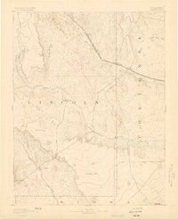
 1891 Sanborn1891 Print · USGSEastern Colorado ranching life at the end of the century centers on isolated outposts and seasonal watercourses. Genealogists can trace family holdings like the Fody Ranch and Orcutt Ranch or the small settlement at Sanborn.
 - 1891 Map of Arroyo
 1891 Arroyo1891 Print · USGSEastern Colorado was still a ranching frontier in the late 1880s as the rail lines expanded across the high plains. Genealogists and historians can trace early holdings like Cox Ranch and Mosley Ranch along the route of the Union Pacific Railroad.
 - 1891 Map of Limon, 1963 Print
 1891 Limon1963 Print · USGSEastern Colorado's rail corridors are captured in the early 1890s as steam-age transit hubs began to reshape the plains. Trace early homesteads and rail junctions at Limon, River Bend, and the Silsby Ranch along the route of the Kansas Pacific Railroad.
 - 1892 Map of Limon
 1892 Limon1892 Print · USGSThe High Plains of eastern Colorado come into focus in the 1890s as a critical railway junction at the meeting of the Elbert and Lincoln county line. Trace early settlements like Agate, River Bend, and Resolis along the path of the Kansas Pacific Railroad.6 unique versions available
 - 1893 Map of Arroyo
 1893 Arroyo1893 Print · USGSEastern Colorado was a landscape of isolated cattle ranches and railway outposts during the late nineteenth century. Researchers can locate early family homesteads like Cox Ranch and follow the route of the Union Pacific Railroad through Bovero.4 unique versions available
 - 1893 Map of Sanborn
 1893 Sanborn1893 Print · USGSEastern Colorado ranching country is documented here during the late frontier era, showing the early cattle operations and water rights of the high plains. Researchers can locate the Maryland Cattle Co. Ranch and trace the paths of Steel Fork and Horse Creek.4 unique versions available
 - 1893 Map of Big Springs
 1893 Big Springs1893 Print · USGSEastern Colorado ranching country is documented here in the late nineteenth century, showing the early homesteads and water sources of the high plains. Researchers can locate the early holdings of Galloway Ranch and Hancock Ranch or trace the drainage of Black Squirrel Creek.5 unique versions available
End of results
Showing maps 1-7 of 7
Top cities of Lincoln County
Frequently asked questions
- What are the different types of historical maps available for Lincoln County?
- What is the oldest map of Lincoln County?
- Where can I purchase historical maps of Lincoln County for my home or office?
- Where can I download high-res historical maps of Lincoln County?
- Are there historical topographic maps available for Lincoln County?
- Is there historical aerial imagery available for Lincoln County?
- Where are historical maps of Lincoln County sourced from?