Old Maps of Lincoln County, Colorado for Metal Detecting
Plan your next treasure hunt with 349 historic maps of Lincoln County. Find old homesites, ghost towns, trails, and gathering spots that may be lost to time — perfect for identifying promising metal detecting locations.
- Locate forgotten sites: Uncover places like long-lost settlements, abandoned rail lines, or gathering spots.
- Plan better hunts: Use map overlays combined with LiDAR or satellite views to narrow in on historically rich areas.
- Made for detectorists: Thousands of hobbyists use these maps to discover relics, coins, and hidden history.
Use these historic maps to boost your research and find new opportunities beneath the surface of Lincoln County.
Lincoln County, CO maps
(349)- 1889 Map of Sanborn, 1962 Print
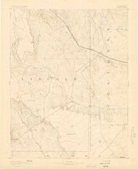
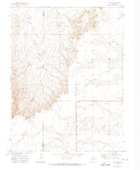
 1889 Sanborn1962 Print · USGSEastern Colorado ranching country is captured here during the late 1880s as the open range gave way to established holdings. Researchers can locate early livestock operations like the Maryland Cattle Co. Ranch, Orcutt Ranch, and the Sanborn settlement.
 - 1891 Map of Sanborn
 1891 Sanborn1891 Print · USGSEastern Colorado ranching life at the end of the century centers on isolated outposts and seasonal watercourses. Genealogists can trace family holdings like the Fody Ranch and Orcutt Ranch or the small settlement at Sanborn.
 - 1891 Map of Arroyo
 1891 Arroyo1891 Print · USGSEastern Colorado was still a ranching frontier in the late 1880s as the rail lines expanded across the high plains. Genealogists and historians can trace early holdings like Cox Ranch and Mosley Ranch along the route of the Union Pacific Railroad.
 - 1891 Map of Limon, 1963 Print
 1891 Limon1963 Print · USGSEastern Colorado's rail corridors are captured in the early 1890s as steam-age transit hubs began to reshape the plains. Trace early homesteads and rail junctions at Limon, River Bend, and the Silsby Ranch along the route of the Kansas Pacific Railroad.
 - 1892 Map of Limon
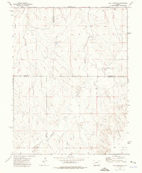
 1892 Limon1892 Print · USGSThe High Plains of eastern Colorado come into focus in the 1890s as a critical railway junction at the meeting of the Elbert and Lincoln county line. Trace early settlements like Agate, River Bend, and Resolis along the path of the Kansas Pacific Railroad.6 unique versions available
 - 1893 Map of Arroyo
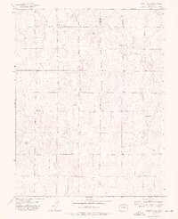
 1893 Arroyo1893 Print · USGSEastern Colorado was a landscape of isolated cattle ranches and railway outposts during the late nineteenth century. Researchers can locate early family homesteads like Cox Ranch and follow the route of the Union Pacific Railroad through Bovero.4 unique versions available
 - 1893 Map of Sanborn
 1893 Sanborn1893 Print · USGSEastern Colorado ranching country is documented here during the late frontier era, showing the early cattle operations and water rights of the high plains. Researchers can locate the Maryland Cattle Co. Ranch and trace the paths of Steel Fork and Horse Creek.4 unique versions available
 - 1893 Map of Big Springs
 1893 Big Springs1893 Print · USGSEastern Colorado ranching country is documented here in the late nineteenth century, showing the early homesteads and water sources of the high plains. Researchers can locate the early holdings of Galloway Ranch and Hancock Ranch or trace the drainage of Black Squirrel Creek.5 unique versions available
 - 1954 Map of Limon
 1954 Limon1954 Print · USGSThe Eastern Colorado plains and the Kansas borderlands come alive in the mid-fifties, showing the vital rail-and-road corridor through Limon. Genealogists and historians can trace the Chicago Rock Island & Pacific line through Burlington and find remote outposts like Arickaree and Anton.4 unique versions available
 - 1954 Map of Lamar, 1964 Print
 1954 Lamar1964 Print · USGSSoutheastern Colorado and the Kansas borderlands appear here in the mid-fifties, dominated by the vital Arkansas River irrigation network. Researchers can trace the development of river towns like Lamar and La Junta alongside the Amity Cemetery and several major reservoirs.3 unique versions available
 - 1954 Map of Pueblo, 1966 Print
 1954 Pueblo1966 Print · USGSMid-century Colorado comes alive in this survey of the Front Range and the high plains as the region expanded after the war. Genealogists and historians can trace family roots through rural landmarks like Hanover Church, Pioneer Cemetery, and the Grandview School.3 unique versions available
 - 1957 Map of Limon
 1957 Limon1957 Print · USGSThe High Plains of Eastern Colorado and Western Kansas come alive in the mid-1950s, showing the vital rail-and-road connections of the era. You can trace the path of the Chicago Rock Island and Pacific through towns like Limon, Stratton, and Burlington or find the early footprint of Bonny Reservoir.
 - 1957 Map of Pueblo
 1957 Pueblo1957 Print · USGSMid-century Colorado comes alive as the Front Range urban centers expand alongside massive Cold War military installations. Genealogists and historians can trace the foundations of Stone City, rural sites like Hanover School, and the industrial Canon Imperial Mine.
 - 1958 Map of Limon
 1958 Limon1958 Print · USGSEastern Colorado and the Kansas border meet in this late-fifties study of High Plains rail and river systems. Researchers can trace the path of the Chicago Rock Island and Pacific through Limon and Burlington, or locate the Bonny Dam and Bonny Reservoir.
 - 1958 Map of Pueblo
 1958 Pueblo1958 Print · USGSColorado's Front Range and Arkansas River Valley come alive in the late fifties, showing the transition from historic mining districts to major military and rail hubs. Genealogists and historians can trace family roots in ranching communities and find landmarks like Cripple Creek, Manitou, and the Hanover School.
 - 1958 Map of Lamar
 1958 Lamar1958 Print · USGSThe High Plains of Eastern Colorado and Western Kansas in the late fifties reveal a landscape tied to the Arkansas River and the rails. Trace the heritage of the river valley through Fort Lyon, the Atchison Topeka and Santa Fe RR, and rural landmarks like Kendrick Church.2 unique versions available
 - 1962 Map of Pueblo
 1962 Pueblo1962 Print · USGSThe Front Range and high plains meet in the early sixties as military installations and industrial mining shape the corridor from Colorado Springs to Pueblo. Genealogists can trace family names through rural landmarks like the Columbine School, Hanover Church, and Fairview Cem.
 - 1966 Map of Pueblo
 1966 Pueblo1966 Print · USGSThe Front Range and Arkansas River Valley are captured here in the mid-1960s, showing a landscape shaped by mining, military expansion, and rail. Researchers can locate numerous country schools and mines, such as the Lytle School, Pioneer Cem, and Empire Zinc Mine.
 - 1970 Map of Limon, 1973 Print
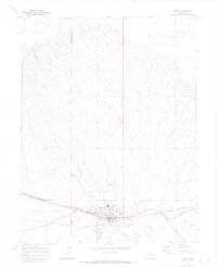 1970 Limon1973 Print · USGSLimon at the start of the 1970s is a bustling rail hub where the High Plains meet critical transport lines. Genealogists and rail historians can trace the intersection of the Union Pacific and Chicago Rock Island and Pacific alongside landmarks like Pershing Mem Cem.
 - 1970 Map of Four Corners, 1973 Print
 1970 Four Corners1973 Print · USGSLincoln County at the start of the 1970s shows a quiet plains landscape defined by the intersection of county lines and rail lines. Local historians can trace the Union Pacific corridor through the Big Sandy Creek valley or locate the Cem near Four Corners.2 unique versions available
 - 1970 Map of Long Creek, 1973 Print
 1970 Long Creek1973 Print · USGSEastern Colorado plains life in the early seventies centered on the essential drainage of Long Creek and Apache Creek. Trace the 1960s-era boundary lines and find remote landmarks like the Gravel Pit and scattered wells across the Elbert-Lincoln county line.
 - 1970 Map of T Draw, 1974 Print
 1970 T Draw1974 Print · USGSEastern Colorado ranching country is documented here in 1970 at the border of Elbert Co and Lincoln Co. Trace the remote Jeep Trail and seasonal water sources along Middlemist Creek or the eponymous T Draw.
 - 1973 Map of Truckton SE, 1975 Print
 1973 Truckton SE1975 Print · USGSThe high plains of eastern Colorado meet at a four-county junction in the early 1970s. Researchers can trace rural family routes like Whittemore Road and Rasner Road past several isolated Water Tanks and fence lines.2 unique versions available
 - 1973 Map of Last Chance SW, 1976 Print
 1973 Last Chance SW1976 Print · USGSThe eastern Colorado plains during the early 1970s are revealed here at the four-county junction of Arapahoe, Washington, Elbert, and Lincoln. Researchers can trace rural landmarks like Brooks Ranch and the winding course of Middlemist Creek across this high-country landscape.
 - 1973 Map of Truckton NE, 1976 Print
 1973 Truckton NE1976 Print · USGSThe eastern Colorado plains at the start of the 1970s show a strictly gridded landscape of rural homesteads and county boundaries. Genealogists and local historians can trace family-named routes like Keller Road and Rush Road, or locate the St Lukes Cem.2 unique versions available
Showing maps 1-25 of 349
Top cities of Lincoln County
Frequently asked questions
- What are the different types of historical maps available for Lincoln County?
- What is the oldest map of Lincoln County?
- Where can I purchase historical maps of Lincoln County for my home or office?
- Where can I download high-res historical maps of Lincoln County?
- Are there historical topographic maps available for Lincoln County?
- Is there historical aerial imagery available for Lincoln County?
- Where are historical maps of Lincoln County sourced from?