1980s Maps of Logan County, Colorado
Explore 6 historic maps of Logan County from the 1980s. These maps offer a rare glimpse into what life looked like during the 1980s — showing old roads, neighborhoods, homes, and landmarks that have changed or disappeared over time.
Whether you're researching your family's past, planning a metal detecting trip, or studying how Logan County's landscape evolved across the 1980s, these high-resolution maps are a powerful tool for exploring the history of this region.
- Focus on a specific era: All maps on this page are from the 1980s, giving you a focused view of this time period.
- See what’s changed: Compare century-old streets, trails, and buildings to today's modern landscape using overlays and satellite layers.
- Research with precision: Use these maps for genealogy, historical research, land use analysis, or educational projects.
- View, download, or print: Maps are fully viewable online in high resolution, and can be downloaded or printed for your own records.
Start exploring Logan County's history through authentic maps from the 1980s. This is your window into the past.
Logan County, CO maps
(6)- 1980 Map of Fort Morgan
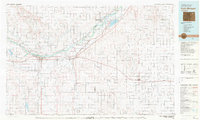 1980 Fort Morgan1980 Print · USGSNortheastern Colorado’s agricultural heartland is documented here in the early eighties, centered on the South Platte River corridor. Researchers can trace the progress of the Union Pacific and Burlington Northern railroads through ranching hubs like Brush, Akron, and Hillrose.
 - 1981 Map of Wray, 1982 Print
 1981 Wray1982 Print · USGSThe high plains at the meeting of Colorado, Nebraska, and Kansas are documented here in the early 1980s. Local researchers can trace the Burlington Northern rail corridor and locate rural landmarks like Lone Star, Glocken Hill, and Dearing Lake.
 - 1983 Map of Julesburg
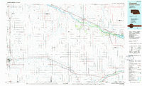
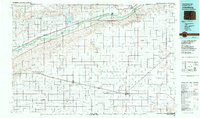 1983 Julesburg1983 Print · USGSNortheastern Colorado and the Nebraska borderlands are captured here in the early eighties, centered on the vital South Platte River valley. Researchers can trace the path of the Union Pacific through towns like Julesburg or explore the rural layout of Peetz Table.
 - 1983 Map of Sterling
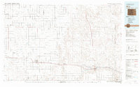
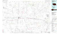
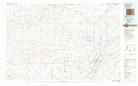 1983 Sterling1983 Print · USGSThe Colorado high plains and the South Platte River valley come into focus in the early 1980s, centered on the hub of Sterling. Researchers can trace old transport routes like the Old Railroad Grade or locate remote outposts like Avalo and Westplains.
 - 1985 Map of Kimball
 1985 Kimball1985 Print · USGSThe Nebraska-Colorado borderlands in the mid-1980s show a landscape of oil production and transcontinental rail. Trace the rail corridor through Bushnell, Dix, and Potter or locate the sprawling Ammunition Depot (Abandoned) near Brownson.2 unique versions available
 - 1985 Map of Chappell, 1986 Print
 1985 Chappell1986 Print · USGSThe Nebraska panhandle comes into focus in the mid-1980s, where the historic Oregon Trail meets the modern Union Pacific rail lines. Trace family roots and land patterns in Sidney, Chappell, and near the Bluewater Battlefield Overlook Site.2 unique versions available
End of results
Showing maps 1-6 of 6
Top cities of Logan County
- Sterling historical maps
- Fleming historical maps
- Merino historical maps
- Peetz historical maps
- Iliff historical maps
- Crook historical maps
Frequently asked questions
- What are the different types of historical maps available for Logan County?
- What is the oldest map of Logan County?
- Where can I purchase historical maps of Logan County for my home or office?
- Where can I download high-res historical maps of Logan County?
- Are there historical topographic maps available for Logan County?
- Is there historical aerial imagery available for Logan County?
- Where are historical maps of Logan County sourced from?