1960s Maps of Dinosaur, Colorado
Explore 4 historic maps of Dinosaur from the 1960s. These maps offer a rare glimpse into what life looked like during the 1960s — showing old roads, neighborhoods, homes, and landmarks that have changed or disappeared over time.
Whether you're researching your family's past, planning a metal detecting trip, or studying how Dinosaur's landscape evolved across the 1960s, these high-resolution maps are a powerful tool for exploring the history of this region.
- Focus on a specific era: All maps on this page are from the 1960s, giving you a focused view of this time period.
- See what’s changed: Compare century-old streets, trails, and buildings to today's modern landscape using overlays and satellite layers.
- Research with precision: Use these maps for genealogy, historical research, land use analysis, or educational projects.
- View, download, or print: Maps are fully viewable online in high resolution, and can be downloaded or printed for your own records.
Start exploring Dinosaur's history through authentic maps from the 1960s. This is your window into the past.
Dinosaur, CO maps
(4)- 1960 Map of Vernal
 1960 Vernal1960 Print · USGSNortheastern Utah was a rugged frontier of mineral extraction and federal conservation in the mid-twentieth century. Genealogists and historians can trace the growth of Vernal, locate Gilsonite mining operations near Bonanza, and explore the 1950s boundaries of Dinosaur National Monument.
 - 1962 Map of Mellen Hill, 1965 Print
 1962 Mellen Hill1965 Print · USGSNorthwestern Colorado’s high desert meets mid-century industrial expansion in the early sixties. Trace the intersection of protected land at Dinosaur National Monument with the oil infrastructure of Rangel Field and Raven Ridge.
 - 1968 Map of Snake John Reef, 1970 Print
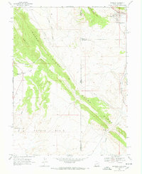
 1968 Snake John Reef1970 Print · USGSThe high desert of the Utah-Colorado border is captured in the late sixties, showing a landscape defined by ranching and rugged geology. Researchers can trace the remote outposts of the era, including Jensen Cabin, K Ranch, and the geological spine of Snake John Reef.2 unique versions available
 - 1968 Map of Dinosaur, 1970 Print
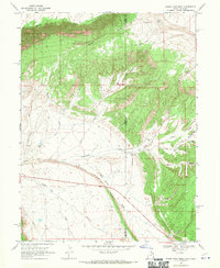
 1968 Dinosaur1970 Print · USGSDinosaur and the rugged high-desert borderlands of Colorado and Utah are captured here in the late sixties. Genealogists and industrial historians can trace the Coyote Basin Oil Field and the early layout of Dinosaur, including its local Cem.2 unique versions available
End of results
Showing maps 1-4 of 4
Top cities near Dinosaur
Frequently asked questions
- What are the different types of historical maps available for Dinosaur?
- What is the oldest map of Dinosaur?
- Where can I purchase historical maps of Dinosaur for my home or office?
- Where can I download high-res historical maps of Dinosaur?
- Are there historical topographic maps available for Dinosaur?
- Is there historical aerial imagery available for Dinosaur?
- Where are historical maps of Dinosaur sourced from?