1900s (20th Century) Maps of Dinosaur, Colorado
Explore 12 historic maps of Dinosaur from the 1900s (20th Century). These maps offer a rare glimpse into what life looked like during the 1900s — showing old roads, neighborhoods, homes, and landmarks that have changed or disappeared over time.
Whether you're researching your family's past, planning a metal detecting trip, or studying how Dinosaur's landscape evolved across the 1900s, these high-resolution maps are a powerful tool for exploring the history of this region.
- Focus on a specific era: All maps on this page are from the 1900s, giving you a focused view of this time period.
- See what’s changed: Compare century-old streets, trails, and buildings to today's modern landscape using overlays and satellite layers.
- Research with precision: Use these maps for genealogy, historical research, land use analysis, or educational projects.
- View, download, or print: Maps are fully viewable online in high resolution, and can be downloaded or printed for your own records.
Start exploring Dinosaur's history through authentic maps from the 1900s. This is your window into the past.
Dinosaur, CO maps
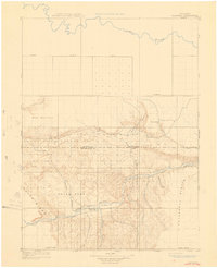
(12)- 1907 Map of Rangely, 1955 Print
 1907 Rangely1955 Print · USGSNorthwestern Colorado at the turn of the century is captured here in a period of early frontier settlement and reconnaissance. Researchers can trace the river-fed outposts of Rangely and Angora or locate landmarks like Blue Mountain and Raven Park.
 - 1907 Map of Jensen, 1957 Print
 1907 Jensen1957 Print · USGSEastern Utah and the Colorado borderlands are shown here at the turn of the century as a frontier of river crossings and ranching outposts. Trace the early Stage Road to Dragon or locate the historic Ferry at Jensen near Dinosaur National Monument.
 - 1910 Map of Jensen
 1910 Jensen1910 Print · USGSThe Utah-Colorado borderlands come alive in the first decade of the twentieth century, showing the early development of the Uinta Basin. Genealogists and historians can locate early river crossings at the ferry sites near Jensen or trace the road to Dragon Stage Road.2 unique versions available
 - 1910 Map of Rangely
 1910 Rangely1910 Print · USGSNorthwestern Colorado at the turn of the century reveals a landscape of isolated outposts and cattle country along the river basins. Genealogists and researchers can trace the early footprints of Rangely, Angora, and Boxelder near the White River.2 unique versions available
 - 1954 Map of Vernal, 1966 Print
 1954 Vernal1966 Print · USGSThe Green River basin and Uinta Mountains come alive in this mid-century survey of northeastern Utah and northwestern Colorado. Genealogists and researchers can trace the development of remote outposts like Little Bonanza, Artesia, and Dutch John alongside the expanding Flaming Gorge Reservoir.4 unique versions available
 - 1958 Map of Vernal
 1958 Vernal1958 Print · USGSThe Uinta Basin at the end of the fifties reveals a landscape shaped by massive river systems and burgeoning energy interests. Researchers can trace the layout of Uintah and Ouray Indian Reservation lands and industrial sites like the Gilsonite coking plant and Bonanza.
 - 1960 Map of Vernal
 1960 Vernal1960 Print · USGSNortheastern Utah was a rugged frontier of mineral extraction and federal conservation in the mid-twentieth century. Genealogists and historians can trace the growth of Vernal, locate Gilsonite mining operations near Bonanza, and explore the 1950s boundaries of Dinosaur National Monument.
 - 1962 Map of Mellen Hill, 1965 Print
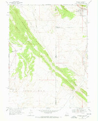
 1962 Mellen Hill1965 Print · USGSNorthwestern Colorado’s high desert meets mid-century industrial expansion in the early sixties. Trace the intersection of protected land at Dinosaur National Monument with the oil infrastructure of Rangel Field and Raven Ridge.
 - 1968 Map of Snake John Reef, 1970 Print
 1968 Snake John Reef1970 Print · USGSThe high desert of the Utah-Colorado border is captured in the late sixties, showing a landscape defined by ranching and rugged geology. Researchers can trace the remote outposts of the era, including Jensen Cabin, K Ranch, and the geological spine of Snake John Reef.2 unique versions available
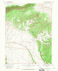
 - 1968 Map of Dinosaur, 1970 Print
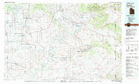
 1968 Dinosaur1970 Print · USGSDinosaur and the rugged high-desert borderlands of Colorado and Utah are captured here in the late sixties. Genealogists and industrial historians can trace the Coyote Basin Oil Field and the early layout of Dinosaur, including its local Cem.2 unique versions available
 - 1979 Map of Rangely
 1979 Rangely1979 Print · USGSNorthwestern Colorado in the late seventies is a landscape of high-desert basins and industrial energy hubs. Local historians can trace the development of the Rangely Oil Field, the layout of Colorado Northwestern Community College, and crossroads at Massadona and Elk Springs.
 - 1980 Map of Vernal, 1982 Print
 1980 Vernal1982 Print · USGSThe Uintah Basin in the early 1980s reveals a unique landscape of deep-rooted settlements and emerging energy fields. Genealogists and historians can trace the foundations of Fort Duchesne and the Ouray National Wildlife Refuge alongside active sites like the Red Wash Oil and Gas Field.2 unique versions available
End of results
Showing maps 1-12 of 12
Top cities near Dinosaur
Frequently asked questions
- What are the different types of historical maps available for Dinosaur?
- What is the oldest map of Dinosaur?
- Where can I purchase historical maps of Dinosaur for my home or office?
- Where can I download high-res historical maps of Dinosaur?
- Are there historical topographic maps available for Dinosaur?
- Is there historical aerial imagery available for Dinosaur?
- Where are historical maps of Dinosaur sourced from?