Old Maps of Paradox - Marie, Colorado for Genealogy
Trace your family roots with 19 historic maps of Paradox - Marie. These high-res maps reveal old neighborhoods, homesites, landmarks, and streets — helping you uncover where your ancestors lived and how the area evolved over time.
- Explore historic neighborhoods: Identify where your relatives may have lived in the 1800s or 1900s.
- Compare maps over time: Trace the changes in streets, buildings, and landmarks for multi-generational research.
- Perfect for genealogy & ancestry research: Used by family historians and researchers to map out lineage and migration.
These maps are an incredible resource for exploring your personal connection to Paradox - Marie's past.
Paradox - Marie, CO maps
(19)- 1916 Map of Paradox Valley, 1955 Print
 1916 Paradox Valley1955 Print · USGSWestern Colorado during the height of early mineral exploration is documented here across the high plateaus and deep river canyons. Genealogists and historians can locate remote outpost camps like Shamrock Camp or Sunny Jim Camp and industrial landmarks such as the Coke Ovens.
 - 1922 Map of Paradox Valley
 1922 Paradox Valley1922 Print · USGSMontrose and San Miguel Counties are shown here during the early twentieth-century mining era, featuring a network of ore-processing camps and early river settlements. Researchers can trace historic industrial sites like the Cashin Mine and Coke Ovens or locate early rural institutions such as the Radium School.2 unique versions available
 - 1948 Map of Paradox, 1957 Print
 1948 Paradox1957 Print · USGSWestern Colorado's canyon country comes into focus in the late 1940s, highlighting the unique drainage of the Paradox Valley. Genealogists and mining historians can locate the old sites of Paradox and Bedrock, or trace the workings of the Cashin Mine.
 - 1949 Map of Paradox
 1949 Paradox1949 Print · USGSWestern Colorado ranching and early mining are well-established in this late 1940s survey. Researchers can trace remote mineral claims like the Cliffdweller Mine and the irrigation network of Paradox Valley near Bedrock.2 unique versions available
 - 1956 Map of Moab, 1972 Print
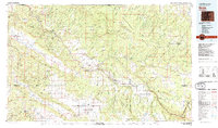
 1956 Moab1972 Print · USGSThe Colorado Plateau and La Sal Mountains appear here in the mid-fifties, just as the uranium boom and energy exploration were reshaping the Four Corners. Researchers can trace the Denver and Rio Grande Western through Cisco or locate the remote outpost of Uravan and Looking Glass Rock.3 unique versions available
 - 1959 Map of Moab
 1959 Moab1959 Print · USGSSoutheast Utah and Western Colorado are mapped here in the late fifties, just as the uranium boom was transforming the remote canyon lands. Genealogists and historians can trace the foundations of Moab and Nucla, or locate mining sites and landmarks like Uravan and Dead Horse Point.
 - 1960 Map of Moab
 1960 Moab1960 Print · USGSThe canyonlands and high plateaus of the Utah-Colorado border are shown here during the mid-century uranium boom. Researchers can trace the river-and-rail corridors of the Colorado River and the Denver and Rio Grande Western near Moab and Uravan.3 unique versions available
 - 1960 Map of Paradox, 1961 Print
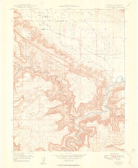
 1960 Paradox1961 Print · USGSWestern Colorado at the height of the post-war mining boom reveals a landscape carved by the Dolores River and its uranium-rich mesas. Local historians can trace the foundations of Paradox and Bedrock alongside dozens of named claims like the Golden Cycle Mine and Shamrock Mines.4 unique versions available
 - 1960 Map of Paradox, 1961 Print
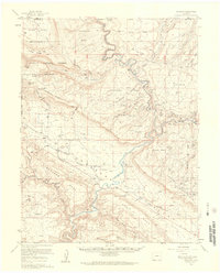
 1960 Paradox1961 Print · USGSIn the Paradox Valley of the early 1960s, the landscape was defined by the intersection of the river and small mining operations. Genealogists can locate residents near the Paradox Cem and trace early industry at the Morning Glory Mine or Bedrock.4 unique versions available
 - 1962 Map of Moab
 1962 Moab1962 Print · USGSThe canyon country of southeastern Utah and western Colorado is captured here in the early sixties, showing the reach of the Denver and Rio Grande Western through the desert. Researchers can trace the layout of mining settlements like Uravan and old railroad stops at Cisco and Sagers Station.
 - 1964 Map of Moab
 1964 Moab1964 Print · USGSThe canyonlands of eastern Utah and western Colorado are captured here in the mid-1960s, a time when uranium mining shaped the local economy. Researchers can trace the river-and-rail network through Sinbad Valley and locate mining outposts like Uravan and Vancorum.
 - 1965 Map of Moab
 1965 Moab1965 Print · USGSSoutheast Utah and Western Colorado are mapped here in the mid-sixties, showcasing a landscape of high plateaus and deep river canyons. Genealogists and historians can trace the mining-era towns of Uravan and Paradox or locate remote landmarks like Castleton and Dead Horse Point.
 - 1983 Map of Nucla
 1983 Nucla1983 Print · USGSWestern Colorado’s canyon country is documented here during the early eighties, showcasing a region defined by uranium mining and high-plateau ranching. Trace local genealogy and industrial footprints through settlements like Uravan and Naturita or remote sites such as the Morning Glory Mine.2 unique versions available
 - 1994 Map of Paradox
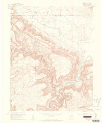
 1994 Paradox1994 Print · USGSParadox Valley in the 1990s remained a landscape defined by its mining heritage and unusual drainage. Geologists and local historians can trace the Cashin Mine, the Paradox Cem, and operations like the Morning Glory Mine.
 - 2011 Map of Paradox, 2011 Print
 2011 Paradox2011 Print · USGSCovers Paradox - Marie, including Bedrock, Montrose County, and other nearby areas
 - 2013 Map of Paradox, 2013 Print
 2013 Paradox2013 Print · USGSCovers Paradox - Marie, including Bedrock, Montrose County, and other nearby areas
 - 2016 Map of Paradox, 2016 Print
 2016 Paradox2016 Print · USGSCovers Paradox - Marie, including Bedrock, Montrose County, and other nearby areas
 - 2019 Map of Paradox, 2019 Print
 2019 Paradox2019 Print · USGSCovers Paradox - Marie, including Bedrock, Montrose County, and other nearby areas
 - 2022 Map of Paradox, 2022 Print
 2022 Paradox2022 Print · USGSMontrose County’s high desert plateaus and the unusual drainage of the Paradox Valley are documented here in the early twenty-first century. Researchers can locate the Paradox Cem near Paradox or trace the winding course of the Dolores River past Bedrock.
End of results
Showing maps 1-19 of 19
Frequently asked questions
- What are the different types of historical maps available for Paradox - Marie?
- What is the oldest map of Paradox - Marie?
- Where can I purchase historical maps of Paradox - Marie for my home or office?
- Where can I download high-res historical maps of Paradox - Marie?
- Are there historical topographic maps available for Paradox - Marie?
- Is there historical aerial imagery available for Paradox - Marie?
- Where are historical maps of Paradox - Marie sourced from?