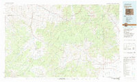
Old Maps of Sargents, Colorado for Metal Detecting
Plan your next treasure hunt with 12 historic maps of Sargents. Find old homesites, ghost towns, trails, and gathering spots that may be lost to time — perfect for identifying promising metal detecting locations.
- Locate forgotten sites: Uncover places like long-lost settlements, abandoned rail lines, or gathering spots.
- Plan better hunts: Use map overlays combined with LiDAR or satellite views to narrow in on historically rich areas.
- Made for detectorists: Thousands of hobbyists use these maps to discover relics, coins, and hidden history.
Use these historic maps to boost your research and find new opportunities beneath the surface of Sargents.
Sargents, CO maps
(12)- 1956 Map of Montrose, 1963 Print
 1956 Montrose1963 Print · USGSThe Colorado western slope in the late fifties and early sixties shows a landscape defined by the Denver & Rio Grande Western RR and the Gunnison River. Trace the development of Blue Mesa Reservoir or locate high-country sites like the Bachelor Mine.3 unique versions available
 - 1959 Map of Montrose
 1959 Montrose1959 Print · USGSWestern Colorado in the late fifties is defined by the high peaks and river valleys of the Southern Rockies. Genealogists and historians can trace the paths of the Denver & Rio Grande Western RR or locate mountain settlements like Crawford, Lazear, and Doyleville.
 - 1960 Map of Montrose
 1960 Montrose1960 Print · USGSThe Colorado high country in the mid-fifties is captured here during a period of steady ranching and persistent mining. Researchers can trace the path of the Denver & Rio Grande Western RR or locate small settlements like Somerset, Maher, and Sargent.2 unique versions available
 - 1964 Map of Sargents, 1967 Print
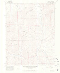 1964 Sargents1967 Print · USGSThe high mountain corridors of Gunnison County are captured in the mid-1960s, a time when the legacy of the narrow-gauge rails was still clearly visible on the land. Researchers can trace the Marshall Pass Railroad Grade through Sargents and locate landmarks like Black Sage Pass and the isolated Grave near the creek.4 unique versions available
 - 1968 Map of Montrose
 1968 Montrose1968 Print · USGSThe Western Slope and Continental Divide meet in the late sixties, showing the vital river valleys and high-mountain mining districts. Trace the historic route of the Denver and Rio Grande Western RR or locate small settlements like Sargents and Powderhorn.
 - 1982 Map of Saguache, 1983 Print
 1982 Saguache1983 Print · USGSThe San Luis Valley meets the high peaks of the Sawatch Range in the early 1980s, revealing a landscape shaped by mining and rail. Researchers can trace the Denver and Rio Grande Western railroad and locate high-altitude sites like the Rawley Mine and the settlement of Bonanza.
 - 2001 Map of Sargents, 2004 Print
 2001 Sargents2004 Print · USGSGunnison County high country at the turn of the millennium shows a landscape shaped by water and high mountain passes. Genealogists and local historians can trace the routes of Marshall Pass Road, the settlement of Sargents, and family-named landmarks like Deacon Jones Gulch.
 - 2011 Map of Sargents, 2011 Print
 2011 Sargents2011 Print · USGSCovers Sargents, including Gunnison County, Saguache County, and other nearby areas
 - 2013 Map of Sargents, 2013 Print
 2013 Sargents2013 Print · USGSCovers Sargents, including Gunnison County, Saguache County, and other nearby areas
 - 2016 Map of Sargents, 2016 Print
 2016 Sargents2016 Print · USGSCovers Sargents, including Gunnison County, Saguache County, and other nearby areas
 - 2019 Map of Sargents, 2019 Print
 2019 Sargents2019 Print · USGSCovers Sargents, including Gunnison County, Saguache County, and other nearby areas
 - 2022 Map of Sargents, 2022 Print
 2022 Sargents2022 Print · USGSHigh in the Gunnison National Forest during the early 2020s, this area centers on the mountain settlement of Sargents. Local historians can trace high-altitude routes like Black Sage Pass and the Marshall Pass Snowmobile Trl through the Sawatch Range.
End of results
Showing maps 1-12 of 12
Top cities near Sargents
Frequently asked questions
- What are the different types of historical maps available for Sargents?
- What is the oldest map of Sargents?
- Where can I purchase historical maps of Sargents for my home or office?
- Where can I download high-res historical maps of Sargents?
- Are there historical topographic maps available for Sargents?
- Is there historical aerial imagery available for Sargents?
- Where are historical maps of Sargents sourced from?