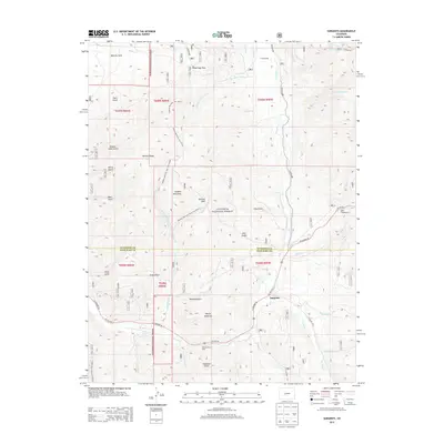
2013 Map of Sargents
USGS Topo · Published 2013About this map
Sargents sits at a critical junction of high-altitude geography and transportation in the southern portion of the Gunnison National Forest. This 2013 survey illustrates the complex drainage systems that define the Continental Divide region, where the Tomichi Cr and its many tributaries, such as Agate Cr and Marshall Cr, carve through the mountainous terrain. The map highlights the intersection of US Highway 50 and historic routes like CO Road 888, reflecting the area's ongoing importance as a passage through the Rockies. Recreational and natural landmarks are prominent, including Waunita Park in the northwest and Black Sage Pass to the north. For those tracing the landscape's utility, the inclusion of Sawmill Gulch and various forest trails, like the Quakey Mountain West Trail 9538.0, offers insight into the timber and transit history of Saguache County.
Find a feature on this map
55 named features on this map. Tap any name to fly to it.
Don’t see what you’re looking for? This feature index may not catch every label — zoom into the map to look around manually.
Map Details
Editions of this 2013 Sargents Map
This is the sole edition of this map. No revisions or reprints were ever made.
Other maps of this area

1940 · Garfield
USGS Topo · 1:62,500

1941 · Pitkin
USGS Topo · 1:62,500

1945 · Pitkin
USGS Topo · 1:62,500

1945 · Garfield
USGS Topo · 1:62,500

1956 · Montrose
USGS Topo · 1:250,000

1959 · Montrose
USGS Topo · 1:250,000

1960 · Montrose
USGS Topo · 1:250,000

1962 · Doyleville
USGS Topo · 1:24,000

1962 · West Baldy
USGS Topo · 1:24,000
1964 · Pitkin
USGS Topo · 1:24,000