1990s Maps of Summit County, Colorado
Explore 4 historic maps of Summit County from the 1990s. These maps offer a rare glimpse into what life looked like during the 1990s — showing old roads, neighborhoods, homes, and landmarks that have changed or disappeared over time.
Whether you're researching your family's past, planning a metal detecting trip, or studying how Summit County's landscape evolved across the 1990s, these high-resolution maps are a powerful tool for exploring the history of this region.
- Focus on a specific era: All maps on this page are from the 1990s, giving you a focused view of this time period.
- See what’s changed: Compare century-old streets, trails, and buildings to today's modern landscape using overlays and satellite layers.
- Research with precision: Use these maps for genealogy, historical research, land use analysis, or educational projects.
- View, download, or print: Maps are fully viewable online in high resolution, and can be downloaded or printed for your own records.
Start exploring Summit County's history through authentic maps from the 1990s. This is your window into the past.
Summit County, CO maps
(4)- 1994 Map of Alma, 1998 Print
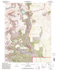 1994 Alma1998 Print · USGSThe high peaks of the Tenmile and Mosquito Ranges come alive in the mid-1990s as this map traces the deep mining history of the South Platte headwaters. Researchers can locate active and former operations like the Sweet Home Mine and Magnolia Mill, or find family names at the Park City Cem.
 - 1994 Map of Montezuma, 1998 Print
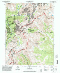 1994 Montezuma1998 Print · USGSThe mining village of Montezuma serves as the focal point for this late-twentieth-century study of the high Continental Divide. Genealogists and historians can trace numerous silver-era sites including the Pennsylvania Mine, Saints John Mine, and Webster Pass.
 - 1994 Map of Boreas Pass, 1998 Print
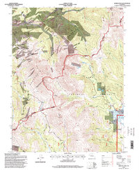 1994 Boreas Pass1998 Print · USGSThe high passes of the Continental Divide in the mid-1990s reveal a landscape shaped by nineteenth-century mining and high-altitude homesteading. Researchers can locate the Parkville and Dyersville sites, trace the Old Toll Road, and find family landmarks like the Schattinger Homestead.
 - 1994 Map of Jefferson, 1998 Print
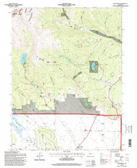 1994 Jefferson1998 Print · USGSThe high passes and ranching valleys of Park County are captured here in the mid-nineties, showing the intersection of the Continental Divide and the basin floor. Researchers can trace historic homesteads and family rangelands like Liesburg Homestead, Wahl Ranch, and 74 Ranch near the Colorado Trail.
End of results
Showing maps 1-4 of 4
Top cities of Summit County
- Breckenridge historical maps
- Silverthorne historical maps
- Frisco historical maps
- Dillon historical maps
- Blue River historical maps
- Montezuma historical maps
See more
Frequently asked questions
- What are the different types of historical maps available for Summit County?
- What is the oldest map of Summit County?
- Where can I purchase historical maps of Summit County for my home or office?
- Where can I download high-res historical maps of Summit County?
- Are there historical topographic maps available for Summit County?
- Is there historical aerial imagery available for Summit County?
- Where are historical maps of Summit County sourced from?