1970s Maps of Summit County, Colorado
Explore 12 historic maps of Summit County from the 1970s. These maps offer a rare glimpse into what life looked like during the 1970s — showing old roads, neighborhoods, homes, and landmarks that have changed or disappeared over time.
Whether you're researching your family's past, planning a metal detecting trip, or studying how Summit County's landscape evolved across the 1970s, these high-resolution maps are a powerful tool for exploring the history of this region.
- Focus on a specific era: All maps on this page are from the 1970s, giving you a focused view of this time period.
- See what’s changed: Compare century-old streets, trails, and buildings to today's modern landscape using overlays and satellite layers.
- Research with precision: Use these maps for genealogy, historical research, land use analysis, or educational projects.
- View, download, or print: Maps are fully viewable online in high resolution, and can be downloaded or printed for your own records.
Start exploring Summit County's history through authentic maps from the 1970s. This is your window into the past.
Summit County, CO maps
(12)- 1970 Map of Vail Pass
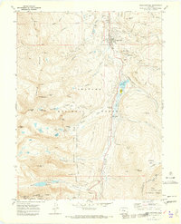
 1970 Vail Pass1970 Print · USGSThe High Rockies at the dawn of the 1970s are defined here by the crossing of the Gore Range and Arapaho National Forest. Trace alpine travel routes like Vail Pass alongside old Mine sites and the settlement at Wheeler Junction.6 unique versions available
 - 1970 Map of Frisco, 1973 Print
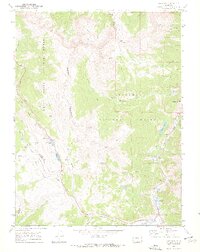
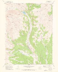
 1970 Frisco1973 Print · USGSFrisco and the Blue River valley appear in the early 1970s as the landscape shifts toward recreation and water storage. Researchers can locate the Masontown site, the Dillon Cem, and mining relics like the dredge near Delaware Flats.4 unique versions available
 - 1970 Map of Vail East, 1973 Print
 1970 Vail East1973 Print · USGSThe Eagle County high country was rapidly evolving in the early seventies as recreation took root near the Eagle-Summit county line. Trace the early development of Vail and the Ski Area alongside mountain landmarks like Bald Mountain.5 unique versions available
 - 1970 Map of Willow Lakes, 1973 Print
 1970 Willow Lakes1973 Print · USGSThe high Gore Range wilderness is documented here in the early 1970s, showing the intersection of two national forests and the Continental Divide. Hikers and historians can trace routes like the Wheeler-Dillon Trail and locate remote sites such as the Boss Mine or Salmon Lake.4 unique versions available
 - 1970 Map of Alma, 1973 Print
 1970 Alma1973 Print · USGSThe Colorado high country around Alma was a hub of hard-rock mining and alpine engineering in the early 1970s. Trace the legacy of the silver and gold era through the Sweet Home Mine, the ruins at Quartzville, and the remote Buckskin Cemetery.4 unique versions available
 - 1970 Map of Red Cliff, 1973 Print
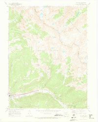
 1970 Red Cliff1973 Print · USGSRed Cliff at the start of the 1970s shows a high-mountain community where mining heritage meets the burgeoning ski industry. Genealogists and historians can locate the local Cemetery, the D & RG W RR line, and historic mining sites like the Hornsilver Mine.5 unique versions available
 - 1970 Map of Dillon, 1973 Print
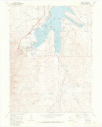
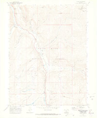
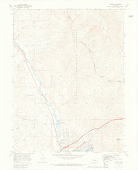 1970 Dillon1973 Print · USGSThe Blue River valley and Williams Fork Mountains are captured here in the early 1970s. Trace the growth of Silverthorne and Dillon near the Dillon Reservoir or follow high-country routes like the Dillon Jeep Trail and Ptarmigan Pass.3 unique versions available
 - 1970 Map of Copper Mountain, 1973 Print
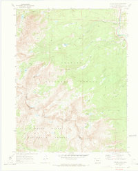
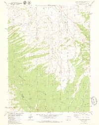
 1970 Copper Mountain1973 Print · USGSIn the early 1970s, this high-country landscape between Summit and Lake counties shows the dramatic scale of industrial mining. Genealogists and historians can trace the foundations of Kokomo and locate legacy shafts like the Queen of the West Mine.4 unique versions available
 - 1970 Map of Breckenridge, 1973 Print
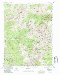
 1970 Breckenridge1973 Print · USGSThe high-altitude mining and ski country of the Tenmile Range is captured here in the early 1970s. Researchers can trace the legacy of the gold era at the Wellington Mine and dredge tailings alongside the emerging Sawmill Ski Area ski lifts.3 unique versions available
 - 1970 Map of Pando, 1973 Print
 1970 Pando1973 Print · USGSHigh in the Rockies during the early seventies, this survey shows the remnants of military and mining activity. Trace the legacy of Camp Hale along the Eagle River or locate the El Capitan Mine and Denver and Rio Grande Western Railroad.6 unique versions available
 - 1974 Map of Montezuma, 1985 Print
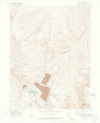
 1974 Montezuma1985 Print · USGSThe high peaks of the Continental Divide in the mid-1970s reveal a landscape shaped by a century of silver mining and early ski development. Researchers can trace historic mining claims like Saints John, find remote camps at Swandyke, and locate the Loveland Pass Tunnel.
 - 1979 Map of Battle Mountain
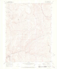
 1979 Battle Mountain1979 Print · USGSHigh-altitude wilderness in the late seventies is captured here as the Arapaho National Forest meets the Williams Fork Mountains. Researchers can trace the rugged drainage of Battle Creek, locate a remote Landing Strip, and explore old jeep trails near Jessmer.4 unique versions available
End of results
Showing maps 1-12 of 12
Top cities of Summit County
- Breckenridge historical maps
- Silverthorne historical maps
- Frisco historical maps
- Dillon historical maps
- Blue River historical maps
- Montezuma historical maps
See more
Frequently asked questions
- What are the different types of historical maps available for Summit County?
- What is the oldest map of Summit County?
- Where can I purchase historical maps of Summit County for my home or office?
- Where can I download high-res historical maps of Summit County?
- Are there historical topographic maps available for Summit County?
- Is there historical aerial imagery available for Summit County?
- Where are historical maps of Summit County sourced from?