Old Maps of Torrington, Connecticut
Explore 20 old maps of Torrington, spanning from 1892 to today. These high-resolution historic maps reveal how streets, neighborhoods, landmarks, and natural features evolved over time — perfect for genealogy, metal detecting, research, and local history exploration.
What you can do with these maps:
- See how Torrington changed over time: Compare historical maps to modern-day views to trace roads, homesites, rail lines & more.
- View detailed metadata: Each map includes creators, publishers, year, scale, and archive source.
- Overlay maps with satellite & LiDAR: Visualize the past alongside modern tools to explore terrain & human change.
- Trusted historical sources: Maps sourced from the USGS, Library of Congress, and other archives.
- Access maps your way: View online, download high-res files, or order prints for personal or research use.
Start exploring old maps of Torrington to uncover forgotten places, hidden landmarks, and the deep history beneath your feet.
Torrington, CT maps
(20)- 1892 Map of Winsted
 1892 Winsted1892 Print · USGSCovers Torrington, including Burlington, Litchfield, and other nearby areas10 unique versions available
 - 1904 Map of Litchfield
 1904 Litchfield1904 Print · USGSCovers Torrington, including Waterbury, Naugatuck, and other nearby areas3 unique versions available
 - 1947 Map of Hartford, 1955 Print
 1947 Hartford1955 Print · USGSCovers Torrington, including Brookhaven, Huntington, and other nearby areas2 unique versions available
 - 1948 Map of Hartford
 1948 Hartford1948 Print · USGSCovers Torrington, including Brookhaven, Huntington, and other nearby areas2 unique versions available
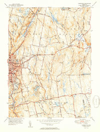
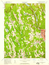
 - 1948 Map of Torrington, 1955 Print
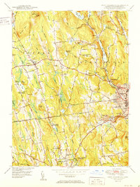
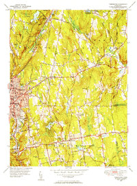 1948 Torrington1955 Print · USGSCovers Torrington, including Burlington, Litchfield, and other nearby areas
 - 1948 Map of Winsted, 1956 Print
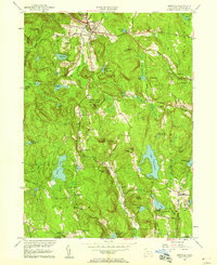
 1948 Winsted1956 Print · USGSCovers Torrington, including Winsted, New Hartford, and other nearby areas
 - 1951 Map of Winsted
 1951 Winsted1951 Print · USGSCovers Torrington, including Winsted, New Hartford, and other nearby areas2 unique versions available
 - 1951 Map of Torrington
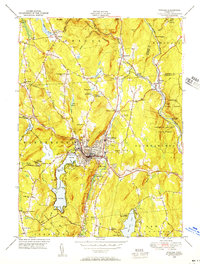
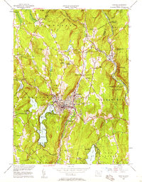
 1951 Torrington1951 Print · USGSCovers Torrington, including Burlington, Litchfield, and other nearby areas2 unique versions available
 - 1951 Map of West Torrington
 1951 West Torrington1951 Print · USGSCovers Torrington, including Litchfield, Litchfield, and other nearby areas2 unique versions available
 - 1951 Map of Norfolk
 1951 Norfolk1951 Print · USGSCovers Torrington, including North Canaan, Goshen, and other nearby areas2 unique versions available
 - 1956 Map of Norfolk, 1958 Print
 1956 Norfolk1958 Print · USGSCovers Torrington, including North Canaan, Goshen, and other nearby areas4 unique versions available
 - 1956 Map of Winsted, 1958 Print
 1956 Winsted1958 Print · USGSCovers Torrington, including Winsted, New Hartford, and other nearby areas7 unique versions available
 - 1956 Map of Torrington, 1958 Print
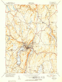
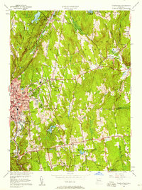 1956 Torrington1958 Print · USGSCovers Torrington, including Burlington, Litchfield, and other nearby areas5 unique versions available
 - 1956 Map of West Torrington, 1958 Print
 1956 West Torrington1958 Print · USGSCovers Torrington, including Litchfield, Litchfield, and other nearby areas5 unique versions available
 - 1961 Map of Hartford
 1961 Hartford1961 Print · USGSCovers Torrington, including Brookhaven, Huntington, and other nearby areas
 - 1962 Map of Hartford, 1971 Print
 1962 Hartford1971 Print · USGSCovers Torrington, including Brookhaven, Huntington, and other nearby areas3 unique versions available
 - 1965 Map of Hartford
 1965 Hartford1965 Print · USGSCovers Torrington, including Brookhaven, Huntington, and other nearby areas2 unique versions available
 - 1965 Map of Norfolk, 1971 Print
 1965 Norfolk1971 Print · USGSCovers Torrington, including North Canaan, Goshen, and other nearby areas
 - 1985 Map of Waterbury, 1986 Print
 1985 Waterbury1986 Print · USGSCovers Torrington, including Waterbury, Poughkeepsie, and other nearby areas
 - 1993 Map of Waterbury
 1993 Waterbury1993 Print · USGSCovers Torrington, including Waterbury, Poughkeepsie, and other nearby areas
End of results
Showing maps 1-20 of 20
Top cities near Torrington
- Waterbury historical maps
- Bristol historical maps
- Southington historical maps
- Farmington historical maps
- Watertown historical maps
- Avon historical maps
See more
Top neighborhoods of Torrington
- West Torrington historical maps
- Wrightville historical maps
- Newberry Corner historical maps
- Newfield historical maps
- Torringford historical maps
- Burrville historical maps
See more
Frequently asked questions
- What are the different types of historical maps available for Torrington?
- What is the oldest map of Torrington?
- Where can I purchase historical maps of Torrington for my home or office?
- Where can I download high-res historical maps of Torrington?
- Are there historical topographic maps available for Torrington?
- Is there historical aerial imagery available for Torrington?
- Where are historical maps of Torrington sourced from?