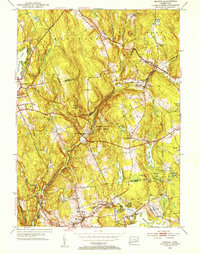
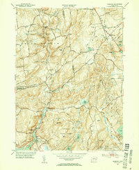
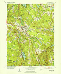
1950s Maps of Southeastern Connecticut Planning Region, Connecticut
Explore 26 historic maps of Southeastern Connecticut Planning Region from the 1950s. These maps offer a rare glimpse into what life looked like during the 1950s — showing old roads, neighborhoods, homes, and landmarks that have changed or disappeared over time.
Whether you're researching your family's past, planning a metal detecting trip, or studying how Southeastern Connecticut Planning Region's landscape evolved across the 1950s, these high-resolution maps are a powerful tool for exploring the history of this region.
- Focus on a specific era: All maps on this page are from the 1950s, giving you a focused view of this time period.
- See what’s changed: Compare century-old streets, trails, and buildings to today's modern landscape using overlays and satellite layers.
- Research with precision: Use these maps for genealogy, historical research, land use analysis, or educational projects.
- View, download, or print: Maps are fully viewable online in high resolution, and can be downloaded or printed for your own records.
Start exploring Southeastern Connecticut Planning Region's history through authentic maps from the 1950s. This is your window into the past.
Southeastern Connecticut Planning Region, CT maps
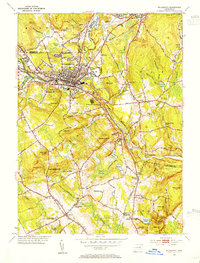
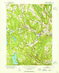
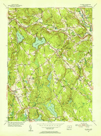
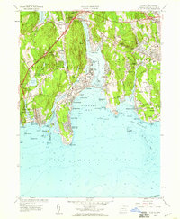
(26)- 1951 Map of Lyme
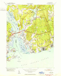 1951 Lyme1951 Print · USGSThe Connecticut shoreline at the start of the fifties shows a transition from quiet rural hills to bustling beach colonies. Trace family roots and local history at the Duck River Cem, Lynde Pt Lighthouse, and the Lyme Sta railroad stop.2 unique versions available
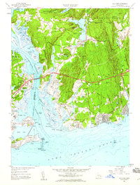
 - 1952 Map of Uncasville
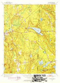
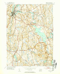
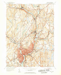
 1952 Uncasville1952 Print · USGSThe Thames River corridor in the early fifties shows a fascinating mix of Ivy League rowing traditions and major state institutions. Trace family roots at Poquetanuck and Ledyard Center, or locate landmarks like the Yale Boathouse and the Norwich State Hospital.2 unique versions available
 - 1952 Map of Moodus, 1953 Print
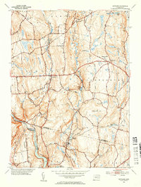
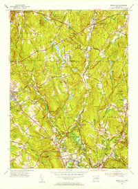
 1952 Moodus1953 Print · USGSThe Moodus area in the early fifties shows a landscape defined by industrial river power and maturing state forests. Genealogists and hikers can trace historic connections between Moodus, Leesville, and the Old Comstock Bridge while locating family plots at Bashan Lake Cem.3 unique versions available
 - 1952 Map of Hamburg, 1954 Print
 1952 Hamburg1954 Print · USGSIn the early 1950s, this pocket of New London County remained a landscape of dense state forests and scattered farmsteads. Researchers can trace numerous family burial sites like Millington Cem or explore the grounds of the Yale Engineering Camp and Devils Hopyard State Park.3 unique versions available
 - 1953 Map of Colchester, 1954 Print
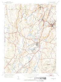
 1953 Colchester1954 Print · USGSColchester and its surrounding hamlets are captured in the early 1950s, revealing a landscape of historic crossroads and family-named corners. Genealogists can trace ancestral locations at St Johns Cem, Exeter Ch, and rural intersections like Avery Corner.7 unique versions available
 - 1953 Map of Willimantic, 1954 Print
 1953 Willimantic1954 Print · USGSWillimantic and its surrounding hill country are captured here in the early fifties, showing a bustling rail junction at the height of its mid-century character. Trace the routes of the Central Vermont Railway, find the historic Trumbull Cem, or locate the old Willimantic State Teachers College.5 unique versions available
 - 1953 Map of Voluntown, 1954 Print
 1953 Voluntown1954 Print · USGSThe Connecticut and Rhode Island borderlands come alive in the 1950s, showing a landscape defined by timber, state forests, and glacial ponds. Researchers can trace family names and landmarks from Voluntown to Rockville, or find sites like Sawmill Pond and Stepstone Falls.5 unique versions available
 - 1953 Map of Scotland, 1954 Print
 1953 Scotland1954 Print · USGSWindham County at mid-century reveals a network of small settlements and river-powered landscapes along the Shetucket River. Genealogists and historians can trace family-named sites like Pudding Hill, the Howard Valley Church, and old burial grounds including Scotland Cem.5 unique versions available
 - 1953 Map of Watch Hill, 1954 Print
 1953 Watch Hill1954 Print · USGSCoastal life and industrial heritage meet at the state line in the early fifties, where the river divides two states. Trace the maritime history of the sound through the Watch Hill Lighthouse, the residential growth of Westerly, and local landmarks like River Bend Cem.7 unique versions available
 - 1953 Map of Fitchville, 1955 Print
 1953 Fitchville1955 Print · USGSNew London County in the early fifties maintains a landscape of river-driven industry and lakeside recreation. Researchers can trace historic turnpikes, the Central Vermont rail line, and family landmarks like Avery Corner and Scott Hill Cem.5 unique versions available
 - 1953 Map of Jewett City, 1955 Print
 1953 Jewett City1955 Print · USGSJewett City and the surrounding Quinebaug valley are captured here in the mid-fifties, showing a landscape of river-driven industry and growing state forests. Researchers can trace old schoolhouse locations like Preston Sch and Glasgo Sch or explore family-named sites such as Taylor Hill and Rix Town.5 unique versions available
 - 1953 Map of Spring Hill, 1955 Print
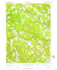
 1953 Spring Hill1955 Print · USGSTolland and Windham counties are shown in the early fifties as the University of Connecticut expanded within a landscape of traditional hill towns. Trace ancestral roots through rural landmarks like Wormwood Hill Cem, the crossroads at Bedlam Corner, and the old rail line at North Windham.4 unique versions available
 - 1953 Map of Ashaway, 1955 Print
 1953 Ashaway1955 Print · USGSThe borderlands of Connecticut and Rhode Island are captured here in the mid-1950s, centered on the river-powered mill towns of the Pawcatuck Valley. Researchers can trace historic industrial sites and neighborhood roots in Westerly, Ashaway, and the riverside hamlet of Potter Hill.5 unique versions available
 - 1953 Map of Plainfield, 1955 Print
 1953 Plainfield1955 Print · USGSWindham County villages are shown in detail during the early 1950s as industry and rail networks still defined the valley. Genealogists can locate family plots at Evergreen Cem and St Johns Cem, or trace the rail sidings at Wauregan Sta.6 unique versions available
 - 1953 Map of Columbia, 1955 Print
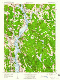
 1953 Columbia1955 Print · USGSTolland County and its surrounding highlands appear here in the mid-1950s, a period when rural schoolhouses and family cemeteries still anchored the community. Genealogists can locate family landmarks like Utley Hill Cem, Porter Sch, and the rail stops along the New York and New Haven and Hartford Railroad.6 unique versions available
 - 1954 Map of Norwich, 1955 Print
 1954 Norwich1955 Print · USGSIn the mid-1950s, the industrial corridors of the Shetucket River and Quinebaug River anchored a landscape of mill towns and neighborhood schools. Trace family sites at St Marys Cem or explore rail history along the New York New Haven and Hartford.5 unique versions available
 - 1954 Map of Plum Island, 1971 Print
 1954 Plum Island1971 Print · USGSCoastal Suffolk County is captured here in the mid-fifties, showing the isolated research facilities and navigation aids that define these waters. Trace the geography of the Plum Island Restricted animal disease lab, the Latham Cem, and Little Gull I.2 unique versions available
 - 1957 Map of Providence
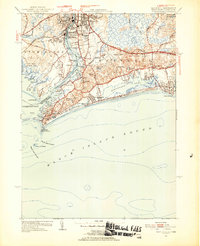
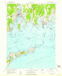
 1957 Providence1957 Print · USGSCoastal New England at the height of the mid-century era shows a landscape shaped by maritime industry and Cold War defense. Genealogists and historians can trace the reach of the New York, New Haven & Hartford RR and locate legacy sites like Fort Adams and Quonset Point Naval Air Station.
 - 1958 Map of Providence
 1958 Providence1958 Print · USGSThe Rhode Island and Massachusetts coastlines are shown in detail during the late 1950s, from the urban cores to the tips of the islands. Researchers can trace the mid-century footprint of Quonset Point Naval Air Station, the defense works at Fort Adams, and the rail network of the New York, New Haven and Hartford RR.
 - 1958 Map of Old Mystic, 1959 Print
 1958 Old Mystic1959 Print · USGSCoastal Connecticut woodland and small hamlets are preserved in this mid-century survey of the Mystic River headwaters. Genealogists can trace family landmarks and schools including Burnetts Corner, Shewville, and the Wheeler High Sch.2 unique versions available
 - 1958 Map of Mystic, 1959 Print
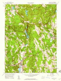
 1958 Mystic1959 Print · USGSThe Connecticut coast flourished as a maritime and rail hub during the late fifties, centered on the historic ship-building villages of the Mystic River. Genealogists can trace family plots at Elm Grove Cemetery and Evergreen Cemetery, while historians can locate the Coast Guard Sta and old Butler School.3 unique versions available
 - 1958 Map of Niantic, 1959 Print
 1958 Niantic1959 Print · USGSThe Connecticut coast at the dawn of the interstate era shows a mix of summer colonies and institutional history. Trace the development of Niantic and East Lyme through landmarks like the State Military Camp, Millstone Quarry, and the New London Airport.3 unique versions available
 - 1958 Map of Old Lyme, 1959 Print
 1958 Old Lyme1959 Print · USGSThe Connecticut shoreline transitions into a new era of travel just as the turnpike is being established near Old Lyme. Genealogists and historians can trace family plots at Duck River Cem or locate the old Lyme Station along the rail line.6 unique versions available
 - 1958 Map of Montville, 1959 Print
 1958 Montville1959 Print · USGSMontville and East Lyme are captured during a period of steady mid-century growth along the Salem Turnpike and rural crossroads. Genealogists and historians can trace family-named landmarks and old burial sites like Whitaker Cem, Oakdale Fox Cem, and Chapel Hill.4 unique versions available
 - 1958 Map of Uncasville, 1960 Print
 1958 Uncasville1960 Print · USGSNew London County's riverfront is captured here in the late fifties, showcasing the vital military and rail corridor along the Thames. Genealogists and historians can trace families near Uncasville, the Submarine Base, and Mohegan Ch.3 unique versions available
Showing maps 1-25 of 26
Top cities of Southeastern Connecticut Planning Region
- Norwich historical maps
- Groton historical maps
- New London historical maps
- Windham historical maps
- Montville historical maps
- Waterford historical maps
See more
Frequently asked questions
- What are the different types of historical maps available for Southeastern Connecticut Planning Region?
- What is the oldest map of Southeastern Connecticut Planning Region?
- Where can I purchase historical maps of Southeastern Connecticut Planning Region for my home or office?
- Where can I download high-res historical maps of Southeastern Connecticut Planning Region?
- Are there historical topographic maps available for Southeastern Connecticut Planning Region?
- Is there historical aerial imagery available for Southeastern Connecticut Planning Region?
- Where are historical maps of Southeastern Connecticut Planning Region sourced from?