1960s Maps of Southeastern Connecticut Planning Region, Connecticut
Explore 6 historic maps of Southeastern Connecticut Planning Region from the 1960s. These maps offer a rare glimpse into what life looked like during the 1960s — showing old roads, neighborhoods, homes, and landmarks that have changed or disappeared over time.
Whether you're researching your family's past, planning a metal detecting trip, or studying how Southeastern Connecticut Planning Region's landscape evolved across the 1960s, these high-resolution maps are a powerful tool for exploring the history of this region.
- Focus on a specific era: All maps on this page are from the 1960s, giving you a focused view of this time period.
- See what’s changed: Compare century-old streets, trails, and buildings to today's modern landscape using overlays and satellite layers.
- Research with precision: Use these maps for genealogy, historical research, land use analysis, or educational projects.
- View, download, or print: Maps are fully viewable online in high resolution, and can be downloaded or printed for your own records.
Start exploring Southeastern Connecticut Planning Region's history through authentic maps from the 1960s. This is your window into the past.
Southeastern Connecticut Planning Region, CT maps
(6)- 1961 Map of Hartford
 1961 Hartford1961 Print · USGSSouthern New England and the Hudson Valley are shown here in the mid-fifties, capturing a landscape of booming coastal cities and interior hill towns. Researchers can trace the legacy of the New York New Haven and Hartford rail corridor and find strategic sites like Camp Shanks and Fort Michie.
 - 1961 Map of Hamburg, 1963 Print
 1961 Hamburg1963 Print · USGSNew London County's wooded interior and river valleys are shown here in the early sixties, highlighting a landscape of state forests and small hamlets. You can locate family burial grounds like Foxtown Cem and Sisson Cem or trace the early footprint of the Stone Ranch Military Reservation.4 unique versions available
 - 1962 Map of Hartford, 1971 Print
 1962 Hartford1971 Print · USGSSouthern New England and the Hudson Valley are shown in the early sixties, as suburban growth reached into the foothills. Trace the path of the New York New Haven & Hartford RR and find landmarks like Camp Nathan Hale and Gillette Castle State Park.3 unique versions available
 - 1963 Map of Providence
 1963 Providence1963 Print · USGSSouthern New England's coastal and industrial heartland is captured here in the early sixties, from the Rhode Island mainland to the far reaches of the Cape. Researchers can trace mid-century growth in Providence or locate landmarks on Marthas Vineyard and Nantucket Island.
 - 1965 Map of Hartford
 1965 Hartford1965 Print · USGSSouthern New England and the Hudson Valley are shown here during the mid-sixties expansion of the Interstate era. Trace the path of the New York New Haven & Hartford RR or locate historic landmarks like West Point Military Reservation and the Merritt Parkway.2 unique versions available
 - 1967 Map of Moodus, 1969 Print
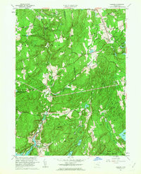
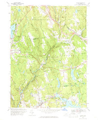 1967 Moodus1969 Print · USGSMiddlesex County hill country and river valleys are captured here in the late sixties, showing a landscape shaped by the Salmon River and its deep forests. Researchers can trace historic cemeteries, the Old Railroad Grade, and local landmarks like the Old Comstock Bridge and Colchester Airfield.4 unique versions available
End of results
Showing maps 1-6 of 6
Top cities of Southeastern Connecticut Planning Region
- Norwich historical maps
- Groton historical maps
- New London historical maps
- Windham historical maps
- Montville historical maps
- Waterford historical maps
See more
Frequently asked questions
- What are the different types of historical maps available for Southeastern Connecticut Planning Region?
- What is the oldest map of Southeastern Connecticut Planning Region?
- Where can I purchase historical maps of Southeastern Connecticut Planning Region for my home or office?
- Where can I download high-res historical maps of Southeastern Connecticut Planning Region?
- Are there historical topographic maps available for Southeastern Connecticut Planning Region?
- Is there historical aerial imagery available for Southeastern Connecticut Planning Region?
- Where are historical maps of Southeastern Connecticut Planning Region sourced from?