1890s Maps of Southeastern Connecticut Planning Region, Connecticut
Explore 8 historic maps of Southeastern Connecticut Planning Region from the 1890s. These maps offer a rare glimpse into what life looked like during the 1890s — showing old roads, neighborhoods, homes, and landmarks that have changed or disappeared over time.
Whether you're researching your family's past, planning a metal detecting trip, or studying how Southeastern Connecticut Planning Region's landscape evolved across the 1890s, these high-resolution maps are a powerful tool for exploring the history of this region.
- Focus on a specific era: All maps on this page are from the 1890s, giving you a focused view of this time period.
- See what’s changed: Compare century-old streets, trails, and buildings to today's modern landscape using overlays and satellite layers.
- Research with precision: Use these maps for genealogy, historical research, land use analysis, or educational projects.
- View, download, or print: Maps are fully viewable online in high resolution, and can be downloaded or printed for your own records.
Start exploring Southeastern Connecticut Planning Region's history through authentic maps from the 1890s. This is your window into the past.
Southeastern Connecticut Planning Region, CT maps
(8)- 1892 Map of Woodstock
 1892 Woodstock1892 Print · USGSNortheastern Connecticut at the close of the nineteenth century was a landscape of river-powered mill villages and independent farmsteads. Genealogists and historians can trace the paths between Mansfield Center, Phoenixville, and the New York and New England Railroad stops.6 unique versions available
 - 1892 Map of New London
 1892 New London1892 Print · USGSCoastal Connecticut at the close of the nineteenth century reveals a landscape defined by its deep-water harbor and expanding rail networks. Genealogists and historians can trace old property lines and neighborhoods near Ft Trumbull, Gale Ferry, and Flanders Village.
 - 1892 Map of Norwich
 1892 Norwich1892 Print · USGSEastern Connecticut's industrial heartland is documented here in the late nineteenth century, showing the critical junction of the Thames, Shetucket, and Yantic rivers. Genealogists and historians can trace the early layouts of manufacturing hubs like Norwich and Willimantic alongside smaller settlements such as Bozrahville and Versailles.8 unique versions available
 - 1892 Map of Gilead
 1892 Gilead1892 Print · USGSEastern Connecticut was a landscape of rail-connected hamlets and water-powered industries in the years before the turn of the century. Genealogists and historians can trace the paths of the Lyman Viaduct, find early settlements like Turnerville, and locate family landmarks near Colchester.7 unique versions available
 - 1893 Map of Moosup
 1893 Moosup1893 Print · USGSEastern Connecticut and western Rhode Island meet here in the late nineteenth century at a peak of rail-driven industry. Genealogists can trace family footprints through historic hubs like Jewett City, Hopkins Hollow, and the mills surrounding Pachaug Pond.7 unique versions available
 - 1893 Map of Stonington
 1893 Stonington1893 Print · USGSThe coastal borderlands of Connecticut and Rhode Island are captured here in the late nineteenth century, showing a landscape defined by maritime trade and river power. Genealogists can trace family landmarks like Ayer Hill and Pequot Hill or locate industrial sites such as the Silex Mine.10 unique versions available
 - 1893 Map of New London
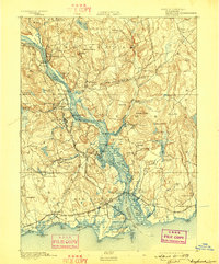
 1893 New London1893 Print · USGSSoutheastern Connecticut at the height of the Victorian era centers on the busy maritime hub of New London and its strategic harbor. Genealogists can trace family holdings and early industry from Gale Ferry to Poquonoc Bridge, while rail enthusiasts can follow the Shore Line Division across the coast.10 unique versions available
 - 1893 Map of Saybrook, 1898 Print
 1893 Saybrook1898 Print · USGSThe Lower Connecticut River valley in the 1890s was a bustling corridor of maritime landings and burgeoning rail junctions. Genealogists and historians can trace the foundations of Old Saybrook, the industrial roots of Ivoryton, and river landings like Goodspeed Landing.8 unique versions available
End of results
Showing maps 1-8 of 8
Top cities of Southeastern Connecticut Planning Region
- Norwich historical maps
- Groton historical maps
- New London historical maps
- Windham historical maps
- Montville historical maps
- Waterford historical maps
See more
Frequently asked questions
- What are the different types of historical maps available for Southeastern Connecticut Planning Region?
- What is the oldest map of Southeastern Connecticut Planning Region?
- Where can I purchase historical maps of Southeastern Connecticut Planning Region for my home or office?
- Where can I download high-res historical maps of Southeastern Connecticut Planning Region?
- Are there historical topographic maps available for Southeastern Connecticut Planning Region?
- Is there historical aerial imagery available for Southeastern Connecticut Planning Region?
- Where are historical maps of Southeastern Connecticut Planning Region sourced from?