1900s (20th Century) Maps of Western Connecticut Planning Region, Connecticut
Explore 94 historic maps of Western Connecticut Planning Region from the 1900s (20th Century). These maps offer a rare glimpse into what life looked like during the 1900s — showing old roads, neighborhoods, homes, and landmarks that have changed or disappeared over time.
Whether you're researching your family's past, planning a metal detecting trip, or studying how Western Connecticut Planning Region's landscape evolved across the 1900s, these high-resolution maps are a powerful tool for exploring the history of this region.
- Focus on a specific era: All maps on this page are from the 1900s, giving you a focused view of this time period.
- See what’s changed: Compare century-old streets, trails, and buildings to today's modern landscape using overlays and satellite layers.
- Research with precision: Use these maps for genealogy, historical research, land use analysis, or educational projects.
- View, download, or print: Maps are fully viewable online in high resolution, and can be downloaded or printed for your own records.
Start exploring Western Connecticut Planning Region's history through authentic maps from the 1900s. This is your window into the past.
Western Connecticut Planning Region, CT maps
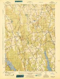
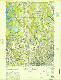
(94)- 1900 Map of Oyster Bay
 1900 Oyster Bay1900 Print · USGSThe North Shore of Long Island is captured at the turn of the century as its maritime villages and sprawling estates began to transition into refined commuter suburbs. Genealogists can trace property and neighborhood development in Sea Cliff, Glen Cove, and Oyster Bay before the automobile era.15 unique versions available
 - 1901 Map of Clove
 1901 Clove1901 Print · USGSDutchess County and the Connecticut borderlands are captured here at the close of the nineteenth century as the rail corridors began to shape local commerce. Genealogists can trace family holdings and old junctions from Dover Plains to Stormville and Moores Mill.11 unique versions available
 - 1901 Map of Northport, 1962 Print
 1901 Northport1962 Print · USGSThe North Shore of Long Island is captured here at the turn of the century, showing a landscape defined by deep harbors and maritime navigation. You can trace the early rail routes of the Long Island RR and locate historic coastal landmarks like Eatons Neck L.H. and Fort Salonga.
 - 1903 Map of Northport
 1903 Northport1903 Print · USGSThe North Shore of Long Island at the turn of the century reveals a landscape defined by deep harbors and the expanding railroad. Genealogists and historians can trace the early layouts of Northport and Huntington, or locate landmarks like Eaton Neck L.H. and Kings Park.8 unique versions available
 - 1904 Map of New Milford
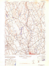
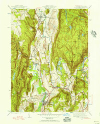
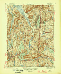
 1904 New Milford1904 Print · USGSLitchfield County at the close of the nineteenth century is defined by the industrial valleys of the Housatonic River and the rural reaches of Washington. Researchers can trace the era's infrastructure through landmarks like Kent Furnace, the Berkshire Division rail line, and the village at Roxbury Station.8 unique versions available
 - 1904 Map of Islip
 1904 Islip1904 Print · USGSSuffolk County at the start of the century reveals a landscape defined by deep north-shore harbors and the expansive Great South Bay. Genealogists and local historians can trace early rail lines through Kings Park and Stony Brook, or locate the sprawling State Hospital and St. Dominic Convent.5 unique versions available
 - 1904 Map of Litchfield
 1904 Litchfield1904 Print · USGSThe Litchfield Hills at the turn of the century are shown here as a landscape of iron heritage and river-powered industry. Genealogists and historians can locate old industrial sites like Kent Furnace, ancestral homes near Sharon Valley, and early rail stops at Limerock Sta..3 unique versions available
 - 1915 Map of Danbury, 1921 Print
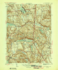
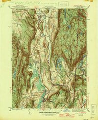
 1915 Danbury1921 Print · USGSFairfield County in the early twentieth century was a hub of railway activity and village life. Genealogists and historians can trace the tracks of the Housatonic Railroad and locate local landmarks like the Fair Grounds or the Putnam Monument.
 - 1928 Map of Carmel
 1928 Carmel1928 Print · USGSNear the New York and Connecticut border during the late 1920s, this landscape shows a network of massive reservoirs built to serve the city. Genealogists and historians can trace rail-era developments like the New York and Harlem RR and locate sites such as the Tilly Foster Mine and Farmers Mills.5 unique versions available
 - 1942 Map of Islip, 1943 Print
 1942 Islip1943 Print · USGSCentral Suffolk County is shown during the early years of the war, as the automobile began to reshape the distance between historic North Shore harbors and the South Shore bays. Researchers can trace the path of the Long Island Motor Parkway, locate family plots at Pinelawn Cem, and identify coastal landmarks like Eaton Neck L H.
 - 1943 Map of Botsford
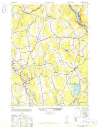
 1943 Botsford1943 Print · USGSFairfield County towns like Botsford and Stepney appear here during the early years of the war, showcasing a landscape of ridge-top villages and new reservoirs. Genealogists and historians can trace rail connections at Botsford Sta or locate family sites near Hattertown and Redding Ridge.
 - 1943 Map of Norwalk North, 1947 Print
 1943 Norwalk North1947 Print · USGSFairfield County towns like Wilton and Weston are captured here during the mid-1940s as infrastructure began to modernize the valley. Researchers can trace the early path of the Merritt Parkway, find the Low-Heywood School, and locate the former Norwalk Airport.2 unique versions available
 - 1943 Map of Norwalk South, 1947 Print
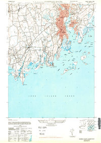
 1943 Norwalk South1947 Print · USGSThe Connecticut shoreline in the 1940s reveals a landscape of growing suburban towns and busy coastal rails. Trace the historic waterfronts of South Norwalk and Darien or explore offshore landmarks like Sheffield Island and Cockenoe Island.
 - 1943 Map of Brewster, 1956 Print
 1943 Brewster1956 Print · USGSThe New York and Connecticut borderlands appear here in the 1940s, showcasing a landscape defined by the Croton Watershed's massive reservoirs. Researchers can trace ancestral locations from Sodom to Milltown, or locate landmarks like Big Elm Sch and Beaver Bog Ch.2 unique versions available
 - 1944 Map of Glenville, 1947 Print
 1944 Glenville1947 Print · USGSFairfield and Westchester counties meet in the 1940s as the regional parkway system begins to reshape the countryside. Genealogists and local historians can trace the foundations of Glenville, the Chieftains Estate, and the grounds of Rosemary Hall.
 - 1944 Map of Dover Plains, 1956 Print
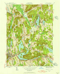
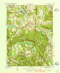
 1944 Dover Plains1956 Print · USGSDutchess County at the close of the Second World War was a landscape of fertile valleys and mountain ridges. Genealogists and historians can trace rail-side life and local landmarks like Dover Plains, the Appalachian Trail, and the Schaghticoke Indian Reservation.2 unique versions available
 - 1945 Map of Peach Lake
 1945 Peach Lake1945 Print · USGSThe hills of Westchester and Fairfield counties appear in the mid-1940s, revealing a landscape defined by glacial lakes and old turnpike crossings. Genealogists can trace family lines through June Cem, the Peach Lake Meeting House, and landmarks in South Salem.3 unique versions available
 - 1945 Map of Pawling, 1956 Print
 1945 Pawling1956 Print · USGSDutchess County at the close of the Second World War reveals a landscape of high ridges and significant wetlands along the New York-Connecticut border. Genealogists and local historians can trace legacy landmarks including the Quaker Hill Meeting House, the village of Pawling, and the vast expanse of The Great Swamp.2 unique versions available
 - 1946 Map of Peach Lake
 1946 Peach Lake1946 Print · USGSThe New York and Connecticut border country comes alive in the mid-1940s, showing a landscape of lakeside hamlets and rising reservoirs. Genealogists and historians can trace local roots through landmarks like the Peach Lake Meeting House, Lewisboro Sch, and Drews Cliff Cem.2 unique versions available
 - 1946 Map of Brewster
 1946 Brewster1946 Print · USGSThe New York and Connecticut state line is defined by massive reservoirs and rural crossroads in the mid-forties. Genealogists can trace family legacies through Union Cem, Big Elm Sch, and the uniquely named settlement of Sodom.2 unique versions available
 - 1947 Map of Mamaroneck
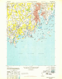
 1947 Mamaroneck1947 Print · USGSCoastal Westchester and Nassau Counties are shown here just after the war as the region's grand estates and suburban centers flourished. Genealogists and historians can locate private landmarks like the J P Morgan property, Pratts Estate, and St Thomas Ch.
 - 1947 Map of Pawling
 1947 Pawling1947 Print · USGSDutchess County at the edge of Connecticut was a landscape of highland ridges and river valleys in the late 1940s. Genealogists can locate family landmarks such as Hurd Sch, Akins Corners, and the historic Quaker Hill Meeting House.2 unique versions available
 - 1947 Map of Dover Plains
 1947 Dover Plains1947 Print · USGSDutchess County at the edge of the Connecticut border reveals a landscape of state institutions, mountain ridges, and river valleys in the late 1940s. Genealogists can trace family landmarks like Valley View Cem or search for old schoolhouses including Dover Furnace Sch and Webatuck Sch.2 unique versions available
 - 1947 Map of Norwalk South
 1947 Norwalk South1947 Print · USGSCoastal Fairfield County's post-war shoreline comes to life here, showing the intricate geography of the Norwalk Islands and growing railroad suburbs. Genealogists and historians can trace family locations through Noroton, Darien, and the unique grounds of the Ferndale Retreat.
 - 1947 Map of Long Hill
 1947 Long Hill1947 Print · USGSFairfield County towns and river valleys are captured here in the years following the war. Genealogists and local historians can trace the rail lines through Long Hill and Stepney or locate landmarks like Monroe and Trap Falls Reservoir.2 unique versions available
Showing maps 1-25 of 94
Top cities of Western Connecticut Planning Region
- Stamford historical maps
- Norwalk historical maps
- Danbury historical maps
- Greenwich historical maps
- Westport historical maps
- Darien historical maps
See more
Frequently asked questions
- What are the different types of historical maps available for Western Connecticut Planning Region?
- What is the oldest map of Western Connecticut Planning Region?
- Where can I purchase historical maps of Western Connecticut Planning Region for my home or office?
- Where can I download high-res historical maps of Western Connecticut Planning Region?
- Are there historical topographic maps available for Western Connecticut Planning Region?
- Is there historical aerial imagery available for Western Connecticut Planning Region?
- Where are historical maps of Western Connecticut Planning Region sourced from?