1950s Maps of Western Connecticut Planning Region, Connecticut
Explore 32 historic maps of Western Connecticut Planning Region from the 1950s. These maps offer a rare glimpse into what life looked like during the 1950s — showing old roads, neighborhoods, homes, and landmarks that have changed or disappeared over time.
Whether you're researching your family's past, planning a metal detecting trip, or studying how Western Connecticut Planning Region's landscape evolved across the 1950s, these high-resolution maps are a powerful tool for exploring the history of this region.
- Focus on a specific era: All maps on this page are from the 1950s, giving you a focused view of this time period.
- See what’s changed: Compare century-old streets, trails, and buildings to today's modern landscape using overlays and satellite layers.
- Research with precision: Use these maps for genealogy, historical research, land use analysis, or educational projects.
- View, download, or print: Maps are fully viewable online in high resolution, and can be downloaded or printed for your own records.
Start exploring Western Connecticut Planning Region's history through authentic maps from the 1950s. This is your window into the past.
Western Connecticut Planning Region, CT maps
(32)- 1950 Map of Kent
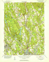
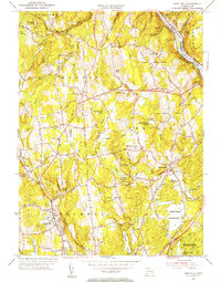
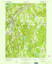
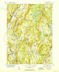 1950 Kent1950 Print · USGSWestern Connecticut's river valleys and ridgelines are captured here at mid-century, following the winding Housatonic River. Researchers can trace the New York New Haven and Hartford RR through Gaylordsville or locate Bulls Bridge and Kent Furnace.2 unique versions available
 - 1950 Map of New Preston
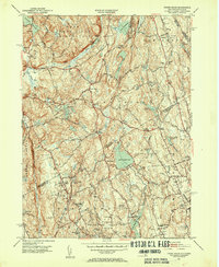
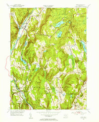
 1950 New Preston1950 Print · USGSLitchfield County's upland terrain is captured here at mid-century, featuring the established summer colonies and rural hamlets of the southern Berkshires. Researchers can trace historic property lines near Lake Waramaug or locate local landmarks like the Gunnery Sch and Washington Depot.2 unique versions available
 - 1951 Map of New Milford
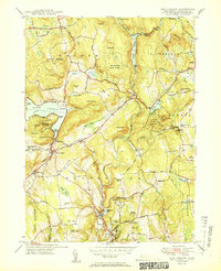
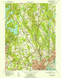
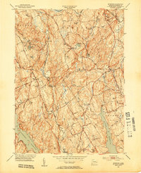
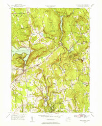
 1951 New Milford1951 Print · USGSLitchfield County's river valleys and reservoirs are captured here in the early fifties, showing the area's transition into a regional recreation hub. Trace the heritage of New Milford and Sherman through landmarks like the Lime Kiln, Candlewood Cave, and the Boardman Sch.2 unique versions available
 - 1951 Map of Westport, 1952 Print
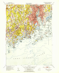
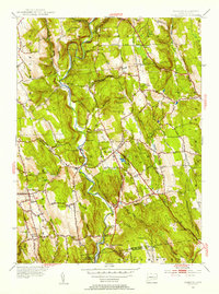
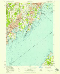
 1951 Westport1952 Print · USGSFairfield and Westport appear here in the early fifties, showing a refined coastal landscape of established estates and watershed reservoirs. Genealogists and researchers can locate several burial grounds, including Gilbertown Cem and Old West Cem, alongside early academic sites like Fairfield University.5 unique versions available
 - 1951 Map of Norwalk North, 1952 Print
 1951 Norwalk North1952 Print · USGSFairfield County towns like Norwalk and Wilton are shown in the early fifties during a period of steady suburban expansion. Genealogists can locate family landmarks like Bald Hill Cem, Hurlbutt Sch, and the old Winnipauk Mill Pond.4 unique versions available
 - 1951 Map of Sherwood Point, 1952 Print
 1951 Sherwood Point1952 Print · USGSThe Connecticut coast at the start of the 1950s shows a landscape of growing seaside neighborhoods and maritime heritage. Genealogists and local historians can trace family-named landmarks from Hale Court and Compo Hills to the shores of Sherwood Millpond.4 unique versions available
 - 1951 Map of Glenville, 1952 Print
 1951 Glenville1952 Print · USGSThe Connecticut and New York border comes alive in the early fifties, showing the interplay of country estates and new infrastructure. Trace family landmarks and local institutions like St Lukes Hospital, Brown Cem, and the County Airport.3 unique versions available
 - 1951 Map of Pound Ridge, 1953 Print
 1951 Pound Ridge1953 Print · USGSThe New York and Connecticut borderlands appear here in the early fifties, showing the rural character of Westchester and Fairfield counties before significant suburbanization. Trace local heritage through family landmarks like Becks Hill and numerous burial sites such as Pound Ridge Cem and Waterbury Cem.3 unique versions available
 - 1951 Map of Norwalk South, 1953 Print
 1951 Norwalk South1953 Print · USGSThe Fairfield County coast comes alive in the early fifties, documenting a landscape of suburban expansion and deep-rooted maritime heritage. Trace local lineages and landmarks from Riverside Cemetery to the New York New Haven and Hartford rail lines.4 unique versions available
 - 1951 Map of Botsford, 1953 Print
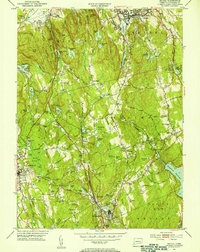
 1951 Botsford1953 Print · USGSFairfield County towns like Botsford and Easton appear in the early fifties as a landscape of traditional villages and vital water infrastructure. Genealogists and historians can trace family-named landmarks like Codfish Hill or locate old community hubs such as Hopewell School and St Patricks Ch.3 unique versions available
 - 1951 Map of Bethel, 1953 Print
 1951 Bethel1953 Print · USGSFairfield County towns like Bethel and Redding are shown in the early fifties during a period of steady growth along the New York New Haven and Hartford rail line. Researchers can trace historic local sites such as the Putnam Memorial Camp Grounds, St Marys Cem, and the old New Redding Sch.2 unique versions available
 - 1953 Map of Newtown, 1955 Print
 1953 Newtown1955 Print · USGSFairfield and New Haven Counties appear here in the early fifties, showing a region defined by river valleys and institutional growth. Researchers can locate family sites at Saint Rose Cem, trace the rail lines through Hawleyville, or explore the grounds of the Fairfield State Hospital.3 unique versions available
 - 1953 Map of Long Hill, 1955 Print
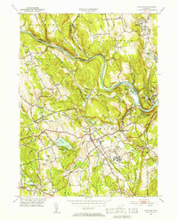
 1953 Long Hill1955 Print · USGSFairfield County's interior settlements and reservoir systems are captured in the early 1950s before significant modern expansion. Researchers can trace ancestral sites like Cutlers Farm Cem, find the old Monroe Sch, and locate the New York New Haven and Hartford RR along the Housatonic River.2 unique versions available
 - 1953 Map of Danbury, 1955 Print
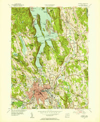 1953 Danbury1955 Print · USGSMid-century Danbury and its surrounding hills show a landscape shaped by the waters of Lake Candlewood and the Still River. Trace the early development of Candlewood Isle, the historic Danbury Fairgrounds, and the State Teachers College.2 unique versions available
 - 1953 Map of Southbury, 1956 Print
 1953 Southbury1956 Print · USGSThe Housatonic valley in the early fifties shows a landscape transitioning between rural life and riverfront recreation. Genealogists can locate family names at Pine Hill Cem and Jacks Hill Cem or trace the early bounds of Kettletown State Park.3 unique versions available
 - 1954 Map of New York
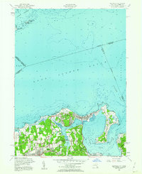
 1954 New York1954 Print · USGSLong Island and the New York metropolitan area are shown during the height of post-war suburbanization. Genealogists and historians can trace the growth of Levittown, the infrastructure of the Long Island Rail Road, and landmarks like Mitchel Afb.2 unique versions available
 - 1954 Map of Bayville, 1956 Print
 1954 Bayville1956 Print · USGSThe Gold Coast of Long Island is captured here in the mid-fifties, showing the transition from grand estates to post-war residential growth. Genealogists and historians can trace family plots at Pratt Cem or locate local landmarks like Mill Neck Manor and the Monastery.2 unique versions available
 - 1954 Map of Lloyd Harbor, 1956 Print
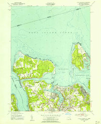 1954 Lloyd Harbor1956 Print · USGSThe North Shore of Long Island is captured in the mid-fifties during a period of refined coastal growth. Genealogists and local historians can trace landmarks like Immaculate Conception Seminary, Coindre Hall, and the historic Fort Hill overlooking Oyster Bay.2 unique versions available
 - 1955 Map of Mount Kisco, 1956 Print
 1955 Mount Kisco1956 Print · USGSUpper Westchester County is seen here during the mid-fifties, showing the sophisticated estate-and-commuter landscape of New York and Connecticut. Trace family history at Oakwood Cem, the Old Quaker Burial Ground, or local landmarks like Westfield State Farm.5 unique versions available
 - 1955 Map of New Milford, 1956 Print
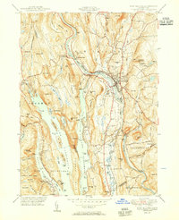
 1955 New Milford1956 Print · USGSMid-century Litchfield County comes into focus as New Milford grows along the Housatonic. Genealogists and historians can trace family plots at Holy Cross Cem and Quaker Cem, or locate the Canterbury Sch and Candlewood Cave.9 unique versions available
 - 1955 Map of Kent, 1956 Print
 1955 Kent1956 Print · USGSLitchfield County in the mid-fifties is a landscape of river-valley towns and upland summer camps. Genealogists and historians can trace rail-era landmarks like Gaylordsville Sta and old burial grounds such as Kent Hollow Cem or Morningside Cem.4 unique versions available
 - 1955 Map of New Preston, 1956 Print
 1955 New Preston1956 Print · USGSLitchfield County's uplands and valleys are meticulously detailed in the mid-1950s, centered on the historic villages of Washington Depot and New Preston. Local historians can trace institutional landmarks like Rumsey Hall Sch and ancestral sites such as Judea Cem along the Shepaug River.7 unique versions available
 - 1955 Map of Roxbury, 1956 Print
 1955 Roxbury1956 Print · USGSThe Shepaug River valley remains a rural stronghold in the mid-fifties, dominated by small villages and hill farms. Genealogists can trace family landmarks like Judds Bridge and Burnham Sch, or locate ancestral plots at Old Leavonworth Cem.5 unique versions available
 - 1955 Map of Mamaroneck, 1958 Print
 1955 Mamaroneck1958 Print · USGSThe Westchester shoreline and Long Island Sound are captured here during a decade of suburban expansion and parkway development. Genealogists and historians can locate family landmarks from Greenwood Union Cemetery to the Webb Institute or the Execution Rocks Lighthouse.2 unique versions available
 - 1957 Map of New York, 1975 Print
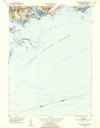
 1957 New York1975 Print · USGSLong Island and the New York metropolitan area are shown in this mid-century survey during a period of massive suburban growth and industrial expansion. Researchers can trace the Long Island RR network and locate landmarks like Fort Tilden or the Brookhaven National Laboratory.
Showing maps 1-25 of 32
Top cities of Western Connecticut Planning Region
- Stamford historical maps
- Norwalk historical maps
- Danbury historical maps
- Greenwich historical maps
- Westport historical maps
- Darien historical maps
See more
Frequently asked questions
- What are the different types of historical maps available for Western Connecticut Planning Region?
- What is the oldest map of Western Connecticut Planning Region?
- Where can I purchase historical maps of Western Connecticut Planning Region for my home or office?
- Where can I download high-res historical maps of Western Connecticut Planning Region?
- Are there historical topographic maps available for Western Connecticut Planning Region?
- Is there historical aerial imagery available for Western Connecticut Planning Region?
- Where are historical maps of Western Connecticut Planning Region sourced from?