1980s Maps of Millville, Delaware
Explore 5 historic maps of Millville from the 1980s. These maps offer a rare glimpse into what life looked like during the 1980s — showing old roads, neighborhoods, homes, and landmarks that have changed or disappeared over time.
Whether you're researching your family's past, planning a metal detecting trip, or studying how Millville's landscape evolved across the 1980s, these high-resolution maps are a powerful tool for exploring the history of this region.
- Focus on a specific era: All maps on this page are from the 1980s, giving you a focused view of this time period.
- See what’s changed: Compare century-old streets, trails, and buildings to today's modern landscape using overlays and satellite layers.
- Research with precision: Use these maps for genealogy, historical research, land use analysis, or educational projects.
- View, download, or print: Maps are fully viewable online in high resolution, and can be downloaded or printed for your own records.
Start exploring Millville's history through authentic maps from the 1980s. This is your window into the past.
Millville, DE maps
(5)- 1980 Map of Frankford, 1982 Print
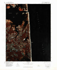
 1980 Frankford1982 Print · USGSSussex County coastal wetlands and agricultural fields are captured in this early 1980s infrared survey. Local researchers can trace the shorelines of Indian River Bay and locate the historic settlements of Dagsboro, Frankford, and Oak Orchard.
 - 1980 Map of Bethany Beach, 1982 Print
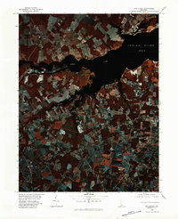
 1980 Bethany Beach1982 Print · USGSThe Delaware coast in the early eighties shows a unique period of growth between the quiet shore and the bays. Trace the development of Bethany Beach and inland towns like Millville and Ocean View along the tidal waters of White Creek.
 - 1984 Map of Frankford
 1984 Frankford1984 Print · USGSIn the 1980s, the Sussex County coast shows a blend of historic farmsteads and burgeoning bayfront communities. Genealogists and historians can trace local roots through landmarks like Prince George Chapel, Carey Cem, and the Nanticoke Indian Center.2 unique versions available
 - 1984 Map of Bethany Beach
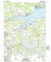
 1984 Bethany Beach1984 Print · USGSThe Delaware coast in the early eighties shows a landscape of growing beach towns and preserved marshes. Trace the development of Bethany Beach and South Bethany, or locate inland landmarks like the Lord Baltimore Sch and Millville.2 unique versions available
 - 1984 Map of Seaford, 1986 Print
 1984 Seaford1986 Print · USGSCoastal Delaware and the Maryland borderlands are captured here in the mid-eighties as modern tourism and traditional agriculture coexist. Researchers can trace the rail-and-river routes through Seaford, explore inland millponds like Chipman Pond, or study the shoreline at Cape Henlopen.2 unique versions available
End of results
Showing maps 1-5 of 5
Top cities near Millville
- Ocean Pines historical maps
- Ocean City historical maps
- West Ocean City historical maps
- Berlin historical maps
- Lewes historical maps
- Millsboro historical maps
See more
Frequently asked questions
- What are the different types of historical maps available for Millville?
- What is the oldest map of Millville?
- Where can I purchase historical maps of Millville for my home or office?
- Where can I download high-res historical maps of Millville?
- Are there historical topographic maps available for Millville?
- Is there historical aerial imagery available for Millville?
- Where are historical maps of Millville sourced from?