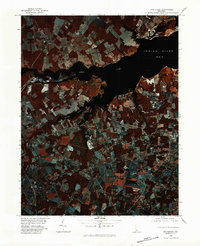
1980 Map of Frankford
USGS Topo · Published 1982About this map
Indian River Bay dominates the northeastern corner of this 1980 infrared orthophotograph, serving as the primary drainage for the surrounding Sussex County agricultural lands. This color infrared imagery, captured in late September, provides a distinct visual signature of land use, where the dark, winding channels of the Indian River, Pepper Creek, and Vines Creek cut through a patchwork of farmed fields and wooded buffers. The layout of the landscape reveals the historical reliance on these waterways for both drainage and local navigation. Key inland settlements like Dagsboro and Frankford are situated along the transit corridors south of the bay, while Oak Orchard and Warwick occupy the northern shores. This specific photographic survey offers a clear view of the rural-to-coastal transition before significant modern expansion altered the footprint of these historic Delaware communities.
Find a feature on this map
8 named features on this map. Tap any name to fly to it.
Don’t see what you’re looking for? This feature index may not catch every label — zoom into the map to look around manually.
Map Details
Editions of this 1980 Frankford Map
This is the sole edition of this map. No revisions or reprints were ever made.
Other maps of this area

1901 · Ocean City
USGS Topo · 1:62,500

1902 · Pittsville
USGS Topo · 1:62,500

1917 · Millsboro
USGS Topo · 1:62,500

1918 · Rehoboth
USGS Topo · 1:62,500

1938 · Millsboro
USGS Topo · 1:62,500

1938 · Rehoboth
USGS Topo · 1:62,500

1942 · Ocean City
USGS Topo · 1:62,500

1942 · Whaleysville
USGS Topo · 1:24,000

1943 · Selbyville
USGS Topo · 1:31,680
1943 · Whaleysville
USGS Topo · 1:31,680