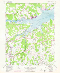
1955 Map of Frankford
USGS Topo · Published 1973About this map
The southern shores of Indian River Bay define this mid-century landscape of coastal inlets and farming districts. The map documents a cluster of traditional rural communities including Dagsboro, Frankford, and Millville, which are connected by the Penn Central rail line and the primary artery of Highway 113. Near the water, the development of summer destinations like Rosedale Beach and Oak Orchard contrasts with the surrounding agricultural fields. Further inland, numerous country landmarks like Prince George Chapel and the John M Clayton Sch provide essential geographic markers for local family history research. The intricate network of tidal coves, such as Ware Cove and Pot Nets Cove, illustrates the area's deep relationship with the Indian River estuary prior to extensive modern expansion.
Find a feature on this map
105 named features on this map. Tap any name to fly to it.
Don’t see what you’re looking for? This feature index may not catch every label — zoom into the map to look around manually.
Map Details
Editions of this 1955 Frankford Map
3 editions found
Other maps of this area

1901 · Ocean City
USGS Topo · 1:62,500

1902 · Pittsville
USGS Topo · 1:62,500

1917 · Millsboro
USGS Topo · 1:62,500

1918 · Rehoboth
USGS Topo · 1:62,500

1938 · Millsboro
USGS Topo · 1:62,500

1938 · Rehoboth
USGS Topo · 1:62,500

1942 · Ocean City
USGS Topo · 1:62,500

1942 · Whaleysville
USGS Topo · 1:24,000

1943 · Selbyville
USGS Topo · 1:31,680
1943 · Whaleysville
USGS Topo · 1:31,680