
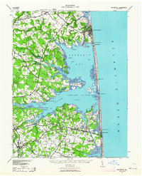
1938 Map of Rehoboth
USGS Topo · Published 1958About this map
Rehoboth Bay and Indian River Bay dominate this coastal Sussex County survey, revealing the delicate balance between the Atlantic shoreline and the inland agricultural communities during the late 1930s. The Pennsylvania RR cuts through the northern landscape, serving the growing resort at Rehoboth, while a network of rural schools like Sunshine Sch, Mary Martin Sch, and Bellmouth Sch serve the interior farming districts. The map documents an era of maritime transition, showing multiple Coast Guard Sta locations along the barrier beach and the vital Indian River Inlet connecting the marshes to the Atlantic Ocean. Inland, concentrated settlements such as Dagsboro and Frankford act as hubs for the surrounding countryside, which is marked by numerous family-named necks and landings, including Pine Neck and Downs Landing.
Find a feature on this map
68 named features on this map. Tap any name to fly to it.
Don’t see what you’re looking for? This feature index may not catch every label — zoom into the map to look around manually.
Map Details
Editions of this 1938 Rehoboth Map
2 editions found
Other maps of this area

1888 · Cape May
USGS Topo · 1:62,500

1893 · Cape May
USGS Topo · 1:62,500

1898 · Cape May
USGS Topo · 1:62,500

1901 · Ocean City
USGS Topo · 1:62,500

1902 · Pittsville
USGS Topo · 1:62,500

1917 · Millsboro
USGS Topo · 1:62,500

1918 · Cedar Creek
USGS Topo · 1:62,500

1918 · Rehoboth
USGS Topo · 1:62,500

1918 · Cape Henlopen
USGS Topo · 1:62,500

1918 · Cape May
USGS Topo · 1:62,500