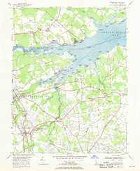
1955 Map of Frankford
USGS Topo · Published 1970About this map
The complex shoreline of the Indian River Bay and its southern tributaries defines this mid-century look at Sussex County. The landscape is a network of necks and points, where the Indian River meets tidal inlets like Vines Creek, Pepper Creek, and Piney Creek. This era shows a rural coastal economy transitioning toward recreation, evidenced by the development at Rosedale Beach and Oak Orchard, while established settlements like Dagsboro and Frankford remain anchored by the Pennsylvania railroad line. Inland, the map is dense with community landmarks essential for genealogical research, including the Prince George Chapel, Antioch Ch, and the George Washington Carver Sch. The intricate drainage patterns, from the Williams Canal to the Beaverdam Ditch, highlight the historical management of these low-lying coastal plains.
Find a feature on this map
105 named features on this map. Tap any name to fly to it.
Don’t see what you’re looking for? This feature index may not catch every label — zoom into the map to look around manually.
Map Details
Editions of this 1955 Frankford Map
3 editions found
Other maps of this area

1901 · Ocean City
USGS Topo · 1:62,500

1902 · Pittsville
USGS Topo · 1:62,500

1917 · Millsboro
USGS Topo · 1:62,500

1918 · Rehoboth
USGS Topo · 1:62,500

1938 · Millsboro
USGS Topo · 1:62,500

1938 · Rehoboth
USGS Topo · 1:62,500

1942 · Ocean City
USGS Topo · 1:62,500

1942 · Whaleysville
USGS Topo · 1:24,000

1943 · Selbyville
USGS Topo · 1:31,680
1943 · Whaleysville
USGS Topo · 1:31,680