
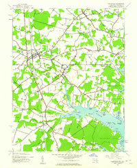
1943 Map of Selbyville
USGS Topo · Published 1943About this map
Selbyville stands as a primary rail and road hub along the Pennsylvania line during the early 1940s, marking the border between Delaware and Maryland. This 1943 survey by the Corps of Engineers details the intricate transition from inland farming communities to the tidal marshes of St Martin Neck. The landscape is defined by its drainage into the St Martin River, where features like Shingle Landing Prong and Slab Bridge Prong illustrate the importance of water access for historical commerce. Small rural centers such as Roxana, Williamsville, and Bishopville are connected by a network of secondary roads, while St Martins Church serves as a local landmark near the Maryland line. The map highlights the intersection of coastal topography and agricultural settlement, showing the clear division between Sussex County and Worcester County.
Find a feature on this map
59 named features on this map. Tap any name to fly to it.
Don’t see what you’re looking for? This feature index may not catch every label — zoom into the map to look around manually.
Map Details
Editions of this 1943 Selbyville Map
2 editions found
Other maps of this area

1901 · Ocean City
USGS Topo · 1:62,500

1902 · Pittsville
USGS Topo · 1:62,500

1917 · Millsboro
USGS Topo · 1:62,500

1918 · Rehoboth
USGS Topo · 1:62,500

1938 · Millsboro
USGS Topo · 1:62,500

1938 · Rehoboth
USGS Topo · 1:62,500

1942 · Ocean City
USGS Topo · 1:62,500

1942 · Ninepin
USGS Topo · 1:24,000

1942 · Ocean City
USGS Topo · 1:24,000

1942 · Whaleysville
USGS Topo · 1:24,000