1990s Maps of Seaford, Delaware
Explore 2 historic maps of Seaford from the 1990s. These maps offer a rare glimpse into what life looked like during the 1990s — showing old roads, neighborhoods, homes, and landmarks that have changed or disappeared over time.
Whether you're researching your family's past, planning a metal detecting trip, or studying how Seaford's landscape evolved across the 1990s, these high-resolution maps are a powerful tool for exploring the history of this region.
- Focus on a specific era: All maps on this page are from the 1990s, giving you a focused view of this time period.
- See what’s changed: Compare century-old streets, trails, and buildings to today's modern landscape using overlays and satellite layers.
- Research with precision: Use these maps for genealogy, historical research, land use analysis, or educational projects.
- View, download, or print: Maps are fully viewable online in high resolution, and can be downloaded or printed for your own records.
Start exploring Seaford's history through authentic maps from the 1990s. This is your window into the past.
Seaford, DE maps
(2)- 1992 Map of Seaford East
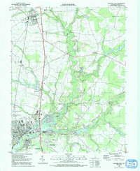 1992 Seaford East1992 Print · USGSSussex County thrives along the Nanticoke River in the early nineties, showing a landscape of established towns and newer waterfront landings. Trace local history at Ross Mansion, the rail lines through Bridgeville, and old community hubs like Hearns Mill.
 - 1992 Map of Seaford West
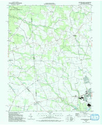 1992 Seaford West1992 Print · USGSThe Delaware-Maryland borderlands come into focus in the early nineties, showing the rural reaches of Sussex County as it meets Federalsburg. Researchers can locate rural landmarks like New Liberty Ch, the crossroads at Atlanta, and old milling sites near Craigs Mill.
End of results
Showing maps 1-2 of 2
Top cities near Seaford
- Milford historical maps
- Delmar historical maps
- Georgetown historical maps
- Denton historical maps
- Laurel historical maps
- Federalsburg historical maps
See more
Top neighborhoods of Seaford
- Ross historical maps
- Seaford Heights historical maps
- Bossard Property historical maps
- The Island historical maps
- Hurley Heights historical maps
Frequently asked questions
- What are the different types of historical maps available for Seaford?
- What is the oldest map of Seaford?
- Where can I purchase historical maps of Seaford for my home or office?
- Where can I download high-res historical maps of Seaford?
- Are there historical topographic maps available for Seaford?
- Is there historical aerial imagery available for Seaford?
- Where are historical maps of Seaford sourced from?