1940s Maps of Whispering Pines, Delaware
Explore 8 historic maps of Whispering Pines from the 1940s. These maps offer a rare glimpse into what life looked like during the 1940s — showing old roads, neighborhoods, homes, and landmarks that have changed or disappeared over time.
Whether you're researching your family's past, planning a metal detecting trip, or studying how Whispering Pines's landscape evolved across the 1940s, these high-resolution maps are a powerful tool for exploring the history of this region.
- Focus on a specific era: All maps on this page are from the 1940s, giving you a focused view of this time period.
- See what’s changed: Compare century-old streets, trails, and buildings to today's modern landscape using overlays and satellite layers.
- Research with precision: Use these maps for genealogy, historical research, land use analysis, or educational projects.
- View, download, or print: Maps are fully viewable online in high resolution, and can be downloaded or printed for your own records.
Start exploring Whispering Pines's history through authentic maps from the 1940s. This is your window into the past.
Whispering Pines, DE maps
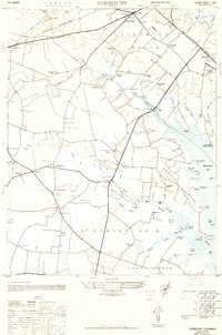
(8)- 1943 Map of Fairmount, 1948 Print
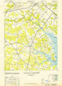 1943 Fairmount1948 Print · USGSSussex County coastal life at the height of the 1940s is detailed here through its intricate network of bay landings, rural crossroads, and early aviation sites. Genealogists can trace family landmarks like Hollymount Cem, Gosling Mill, and the many small settlements including Robinsonville and Jimtown.
 - 1944 Map of Lewes
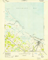 1944 Lewes1944 Print · USGSThe maritime landscape of the Delaware Bay shore comes alive in this mid-century survey of the Lewes area. Genealogists and historians can trace family-named crossroads and rural landmarks such as Whites Chapel, Pilottown, and the Pennsylvania railroad line.2 unique versions available
 - 1944 Map of Cape Henlopen
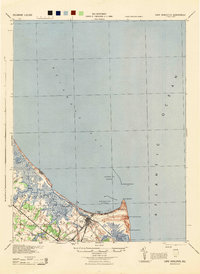 1944 Cape Henlopen1944 Print · USGSCoastal Delaware during the mid-forties reveals a landscape of vital maritime defense and rural crossroads. Genealogists and historians can trace the Pennsylvania rail line through Lewes and locate landmarks like the West Hill Sch and Coast Guard Sta.
 - 1944 Map of Rehoboth
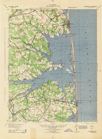 1944 Rehoboth1944 Print · USGSSussex County’s Atlantic coast was a network of tidal bays and rural school districts during the mid-forties. Genealogists and local historians can trace family-named landmarks like Mary Martin Sch, the Rehoboth Beach Airport, and the Assawoman Canal.
 - 1946 Map of Salisbury, 1948 Print
 1946 Salisbury1948 Print · USGSThe Delmarva Peninsula in the late nineteen-forties shows a landscape defined by its deep river arteries and emerging coastal defenses. Genealogists and historians can trace rail-connected towns like Federalsburg or locate maritime landmarks such as the Ocean City Seaplane Base and Fort Miles Military Reservation.4 unique versions available
 - 1947 Map of Salisbury, 1948 Print
 1947 Salisbury1948 Print · USGSThe Delmarva Peninsula in the late forties reveals a coastal landscape of maritime defense and growing seaside towns. Trace the post-war footprint of Salisbury, the strategic Fort Miles Military Reservation, and the Ocean City Seaplane Base.
 - 1948 Map of Fairmount, 1949 Print
 1948 Fairmount1949 Print · USGSCoastal Sussex County is captured here in the late forties, showing the rural landscapes of Fairmount and Angola before modern development. Genealogists can locate family landmarks like Hollymount Cem, Wesley Ch, and the Friendship Sch.
 - 1948 Map of Salisbury, 1951 Print
 1948 Salisbury1951 Print · USGSThe Delmarva Peninsula in the late 1940s is shown here as a busy network of rail-towns and coastal outposts. Researchers can trace the legacy of the Pennsylvania Railroad through inland hubs like Georgetown or the maritime reaches of Crisfield and Cape May.
End of results
Showing maps 1-8 of 8
Top cities near Whispering Pines
- Lower Township historical maps
- Milford historical maps
- Georgetown historical maps
- Lewes historical maps
- Millsboro historical maps
- Milton historical maps
See more
Frequently asked questions
- What are the different types of historical maps available for Whispering Pines?
- What is the oldest map of Whispering Pines?
- Where can I purchase historical maps of Whispering Pines for my home or office?
- Where can I download high-res historical maps of Whispering Pines?
- Are there historical topographic maps available for Whispering Pines?
- Is there historical aerial imagery available for Whispering Pines?
- Where are historical maps of Whispering Pines sourced from?