1980s Maps of Whispering Pines, Delaware
Explore 5 historic maps of Whispering Pines from the 1980s. These maps offer a rare glimpse into what life looked like during the 1980s — showing old roads, neighborhoods, homes, and landmarks that have changed or disappeared over time.
Whether you're researching your family's past, planning a metal detecting trip, or studying how Whispering Pines's landscape evolved across the 1980s, these high-resolution maps are a powerful tool for exploring the history of this region.
- Focus on a specific era: All maps on this page are from the 1980s, giving you a focused view of this time period.
- See what’s changed: Compare century-old streets, trails, and buildings to today's modern landscape using overlays and satellite layers.
- Research with precision: Use these maps for genealogy, historical research, land use analysis, or educational projects.
- View, download, or print: Maps are fully viewable online in high resolution, and can be downloaded or printed for your own records.
Start exploring Whispering Pines's history through authentic maps from the 1980s. This is your window into the past.
Whispering Pines, DE maps
(5)- 1980 Map of Fairmount, 1982 Print
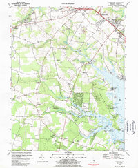
 1980 Fairmount1982 Print · USGSSussex County, Delaware, is captured in the early eighties as a mosaic of tidal marshes and family farms. Researchers can trace the layout of rural communities like Robinsonville and Belltown or study the shoreline along Rehoboth Bay.
 - 1980 Map of Lewes, 1982 Print
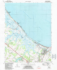
 1980 Lewes1982 Print · USGSSussex County's shoreline and coastal marshes appear in vivid infrared detail in the early eighties. Genealogists and local historians can trace the development of Lewes Beach and identify landmarks like Red Mill Pond and the Broadkill River.
 - 1984 Map of Lewes
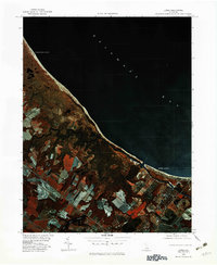
 1984 Lewes1984 Print · USGSThe Sussex County coast in the mid-1980s reveals a landscape of protected wetlands and maritime industry. Genealogists can trace family names at Whites Chapel or Henlopen Memorial Park, while explorers find old landings like Hazzard Landing.3 unique versions available
 - 1984 Map of Fairmount
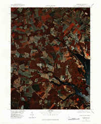
 1984 Fairmount1984 Print · USGSSussex County coastal life in the mid-1980s is centered on the tidal reaches of Rehoboth Bay and its inland farming communities. Genealogists and historians can trace local roots through landmarks like the Indian Mission Ch, Goslee Millpond, and St Georges Chapel.3 unique versions available
 - 1984 Map of Seaford, 1986 Print
 1984 Seaford1986 Print · USGSCoastal Delaware and the Maryland borderlands are captured here in the mid-eighties as modern tourism and traditional agriculture coexist. Researchers can trace the rail-and-river routes through Seaford, explore inland millponds like Chipman Pond, or study the shoreline at Cape Henlopen.2 unique versions available
End of results
Showing maps 1-5 of 5
Top cities near Whispering Pines
- Lower Township historical maps
- Milford historical maps
- Georgetown historical maps
- Lewes historical maps
- Millsboro historical maps
- Milton historical maps
See more
Frequently asked questions
- What are the different types of historical maps available for Whispering Pines?
- What is the oldest map of Whispering Pines?
- Where can I purchase historical maps of Whispering Pines for my home or office?
- Where can I download high-res historical maps of Whispering Pines?
- Are there historical topographic maps available for Whispering Pines?
- Is there historical aerial imagery available for Whispering Pines?
- Where are historical maps of Whispering Pines sourced from?