1900s (20th Century) Maps of Farmdale, Florida
Explore 9 historic maps of Farmdale from the 1900s (20th Century). These maps offer a rare glimpse into what life looked like during the 1900s — showing old roads, neighborhoods, homes, and landmarks that have changed or disappeared over time.
Whether you're researching your family's past, planning a metal detecting trip, or studying how Farmdale's landscape evolved across the 1900s, these high-resolution maps are a powerful tool for exploring the history of this region.
- Focus on a specific era: All maps on this page are from the 1900s, giving you a focused view of this time period.
- See what’s changed: Compare century-old streets, trails, and buildings to today's modern landscape using overlays and satellite layers.
- Research with precision: Use these maps for genealogy, historical research, land use analysis, or educational projects.
- View, download, or print: Maps are fully viewable online in high resolution, and can be downloaded or printed for your own records.
Start exploring Farmdale's history through authentic maps from the 1900s. This is your window into the past.
Farmdale, FL maps
(9)- 1945 Map of Allanton
 1945 Allanton1945 Print · USGSCoastal Florida near the end of the Second World War was a landscape of intricate bayous and small fishing settlements. You can trace the early footprints of Allanton and Farmdale along the shores of East Bay and the Wetappo Intracoastal Waterway Creek.3 unique versions available
 - 1947 Map of Allanton
 1947 Allanton1947 Print · USGSThe Florida Panhandle coast near East Bay is shown here in the late 1940s, just as the regional waterway system was maturing. Historians can trace the early footprints of Allanton and Farmdale or follow the route of the Wetappo Intracoastal Waterway.
 - 1954 Map of Tallahassee, 1967 Print
 1954 Tallahassee1967 Print · USGSThe Florida Panhandle and South Georgia are captured here during a period of mid-century growth and military expansion. Researchers can trace the development of Panama City, the footprint of Tyndall Air Force Base, and the rail lines of the Atlantic Coast Line.4 unique versions available
 - 1956 Map of Allanton, 1957 Print
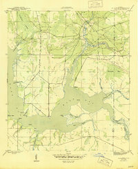
 1956 Allanton1957 Print · USGSCoastal Bay County in the mid-1950s is a landscape of winding inlets and emerging military sites. Researchers can trace the waterfront settlements of Allanton and Farmdale or locate family sites like the Farmdale Cem and Bull Point.2 unique versions available
 - 1959 Map of Tallahassee
 1959 Tallahassee1959 Print · USGSFlorida's Panhandle and the Big Bend region appear here in the mid-fifties, showing a landscape defined by its great river systems and developing coast. Trace the early layout of Panama City, the expansive Apalachicola National Forest, and the coastal St Marks Lighthouse.
 - 1960 Map of Tallahassee
 1960 Tallahassee1960 Print · USGSThe Florida Panhandle and southern Georgia are captured here in the mid-twentieth century, showing a region defined by its rivers and military installations. Genealogists and historians can trace the growth of Tallahassee or locate coastal landmarks like the St Marks Lighthouse and Tyndall Air Force Base.
 - 1981 Map of Panama City
 1981 Panama City1981 Print · USGSPanama City and the Florida Panhandle coast are captured here in the early eighties, showing the region's balance of military installations and maritime industry. Researchers can trace the Atlanta and St Andrews Bay RR or locate coastal sites like Tyndall Air Force Base and Dead Lake.2 unique versions available
 - 1982 Map of Allanton, 1983 Print
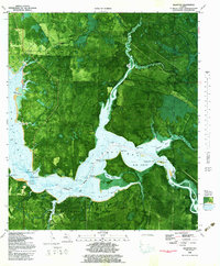 1982 Allanton1983 Print · USGSThe Florida panhandle coast comes into focus in the early eighties as Tyndall Air Force Base meets the waters of East Bay. Trace the maritime history of Allanton and Farmdale alongside the path of the Intracoastal Waterway.2 unique versions available
 - 1988 Map of Tallahassee
 1988 Tallahassee1988 Print · USGSThe Florida Panhandle and South Georgia are captured here in the late eighties, showing the expansion of the regional highway network and coastal growth. Genealogists and historians can trace rail lines like the Seaboard System Railroad or locate family roots in Blountstown, Graceville, or Crawfordville.2 unique versions available
End of results
Showing maps 1-9 of 9
Top cities near Farmdale
- Panama City historical maps
- Lynn Haven historical maps
- Callaway historical maps
- Springfield historical maps
- Parker historical maps
- Port Saint Joe historical maps
See more
Frequently asked questions
- What are the different types of historical maps available for Farmdale?
- What is the oldest map of Farmdale?
- Where can I purchase historical maps of Farmdale for my home or office?
- Where can I download high-res historical maps of Farmdale?
- Are there historical topographic maps available for Farmdale?
- Is there historical aerial imagery available for Farmdale?
- Where are historical maps of Farmdale sourced from?