1940s Maps of Parker, Florida
Explore 2 historic maps of Parker from the 1940s. These maps offer a rare glimpse into what life looked like during the 1940s — showing old roads, neighborhoods, homes, and landmarks that have changed or disappeared over time.
Whether you're researching your family's past, planning a metal detecting trip, or studying how Parker's landscape evolved across the 1940s, these high-resolution maps are a powerful tool for exploring the history of this region.
- Focus on a specific era: All maps on this page are from the 1940s, giving you a focused view of this time period.
- See what’s changed: Compare century-old streets, trails, and buildings to today's modern landscape using overlays and satellite layers.
- Research with precision: Use these maps for genealogy, historical research, land use analysis, or educational projects.
- View, download, or print: Maps are fully viewable online in high resolution, and can be downloaded or printed for your own records.
Start exploring Parker's history through authentic maps from the 1940s. This is your window into the past.
Parker, FL maps
(2)- 1944 Map of Long Point
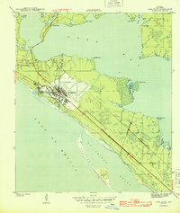 1944 Long Point1944 Print · USGSThe Florida Panhandle coast during the Second World War was a landscape defined by rapid military expansion. Researchers can trace the early layout of Tyndall Field and explore the shoreline of St Andrew Sound and the settlement at San Blas.3 unique versions available
 - 1945 Map of Parker
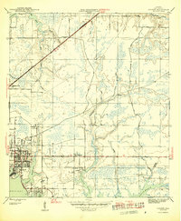 1945 Parker1945 Print · USGSCoastal development along the Florida Panhandle is captured mid-century, showing the growing residential and industrial hubs near the water. Researchers can trace the layout of Springfield, Bay Harbor, and Parker, alongside the path of the Atlanta and St Andrews Bay railroad.2 unique versions available
End of results
Showing maps 1-2 of 2
Top cities near Parker
- Panama City historical maps
- Upper Grand Lagoon historical maps
- Lynn Haven historical maps
- Callaway historical maps
- Panama City Beach historical maps
- Springfield historical maps
See more
Top neighborhoods of Parker
Frequently asked questions
- What are the different types of historical maps available for Parker?
- What is the oldest map of Parker?
- Where can I purchase historical maps of Parker for my home or office?
- Where can I download high-res historical maps of Parker?
- Are there historical topographic maps available for Parker?
- Is there historical aerial imagery available for Parker?
- Where are historical maps of Parker sourced from?