1940s Maps of Vicksburg, Florida
Explore 2 historic maps of Vicksburg from the 1940s. These maps offer a rare glimpse into what life looked like during the 1940s — showing old roads, neighborhoods, homes, and landmarks that have changed or disappeared over time.
Whether you're researching your family's past, planning a metal detecting trip, or studying how Vicksburg's landscape evolved across the 1940s, these high-resolution maps are a powerful tool for exploring the history of this region.
- Focus on a specific era: All maps on this page are from the 1940s, giving you a focused view of this time period.
- See what’s changed: Compare century-old streets, trails, and buildings to today's modern landscape using overlays and satellite layers.
- Research with precision: Use these maps for genealogy, historical research, land use analysis, or educational projects.
- View, download, or print: Maps are fully viewable online in high resolution, and can be downloaded or printed for your own records.
Start exploring Vicksburg's history through authentic maps from the 1940s. This is your window into the past.
Vicksburg, FL maps
(2)- 1943 Map of Southport, 1973 Print
 1943 Southport1973 Print · USGSCoastal Bay County during the mid-forties reveals a landscape of tidal inlets and early bridge crossings before the modern expansion of Panama City. Genealogists and local researchers can trace early settlements at Southport and Vicksburg, or locate landmarks like the Vicksburg Fire Tower and North Bay Bridge.
 - 1944 Map of Southport
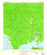 1944 Southport1944 Print · USGSThe shores of North Bay and West Bay are captured here during the mid-1940s, showing a landscape defined by tidal bayous and early coastal settlements. Local historians can trace the road networks connecting Southport, Vicksburg, and the early layout of Lynn Haven.5 unique versions available
End of results
Showing maps 1-2 of 2
Top cities near Vicksburg
- Panama City historical maps
- Upper Grand Lagoon historical maps
- Lynn Haven historical maps
- Callaway historical maps
- Panama City Beach historical maps
- Springfield historical maps
See more
Frequently asked questions
- What are the different types of historical maps available for Vicksburg?
- What is the oldest map of Vicksburg?
- Where can I purchase historical maps of Vicksburg for my home or office?
- Where can I download high-res historical maps of Vicksburg?
- Are there historical topographic maps available for Vicksburg?
- Is there historical aerial imagery available for Vicksburg?
- Where are historical maps of Vicksburg sourced from?