Old Maps of Vicksburg, Florida for Academic Research
Study the evolution of Vicksburg with 13 high-resolution historic maps. Whether you're teaching, researching, or modeling changes in land use, these maps provide essential visual documentation of urban, environmental, and geographic change.
- Analyze long-term change: Track patterns in development, transportation, and natural features.
- Ideal for environmental or urban studies: Support academic projects with primary historical map data.
- Use in the classroom or lab: Educators and researchers rely on these maps to bring historical context to life.
These maps are a powerful tool for teaching, research, and visualizing how Vicksburg has changed over the decades.
Vicksburg, FL maps
(13)- 1943 Map of Southport, 1973 Print
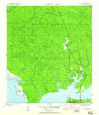
 1943 Southport1973 Print · USGSCoastal Bay County during the mid-forties reveals a landscape of tidal inlets and early bridge crossings before the modern expansion of Panama City. Genealogists and local researchers can trace early settlements at Southport and Vicksburg, or locate landmarks like the Vicksburg Fire Tower and North Bay Bridge.
 - 1944 Map of Southport
 1944 Southport1944 Print · USGSThe shores of North Bay and West Bay are captured here during the mid-1940s, showing a landscape defined by tidal bayous and early coastal settlements. Local historians can trace the road networks connecting Southport, Vicksburg, and the early layout of Lynn Haven.5 unique versions available
 - 1954 Map of Tallahassee, 1967 Print
 1954 Tallahassee1967 Print · USGSThe Florida Panhandle and South Georgia are captured here during a period of mid-century growth and military expansion. Researchers can trace the development of Panama City, the footprint of Tyndall Air Force Base, and the rail lines of the Atlantic Coast Line.4 unique versions available
 - 1959 Map of Tallahassee
 1959 Tallahassee1959 Print · USGSFlorida's Panhandle and the Big Bend region appear here in the mid-fifties, showing a landscape defined by its great river systems and developing coast. Trace the early layout of Panama City, the expansive Apalachicola National Forest, and the coastal St Marks Lighthouse.
 - 1960 Map of Tallahassee
 1960 Tallahassee1960 Print · USGSThe Florida Panhandle and southern Georgia are captured here in the mid-twentieth century, showing a region defined by its rivers and military installations. Genealogists and historians can trace the growth of Tallahassee or locate coastal landmarks like the St Marks Lighthouse and Tyndall Air Force Base.
 - 1981 Map of Panama City
 1981 Panama City1981 Print · USGSPanama City and the Florida Panhandle coast are captured here in the early eighties, showing the region's balance of military installations and maritime industry. Researchers can trace the Atlanta and St Andrews Bay RR or locate coastal sites like Tyndall Air Force Base and Dead Lake.2 unique versions available
 - 1982 Map of Southport, 1984 Print
 1982 Southport1984 Print · USGSThe coastal wetlands and timberlands of Bay County are shown in detail as they appeared in the early eighties. Researchers can trace early infrastructure and industry through sites like the Shrimp Farm, the Bailey Bridge, and the community of Southport.3 unique versions available
 - 1988 Map of Tallahassee
 1988 Tallahassee1988 Print · USGSThe Florida Panhandle and South Georgia are captured here in the late eighties, showing the expansion of the regional highway network and coastal growth. Genealogists and historians can trace rail lines like the Seaboard System Railroad or locate family roots in Blountstown, Graceville, or Crawfordville.2 unique versions available
 - 2012 Map of Southport, 2012 Print
 2012 Southport2012 Print · USGSCovers Vicksburg, including Lynn Haven, Southport, and other nearby areas
 - 2015 Map of Southport, 2015 Print
 2015 Southport2015 Print · USGSCovers Vicksburg, including Lynn Haven, Southport, and other nearby areas
 - 2018 Map of Southport, 2018 Print
 2018 Southport2018 Print · USGSCovers Vicksburg, including Lynn Haven, Southport, and other nearby areas
 - 2021 Map of Southport, 2021 Print
 2021 Southport2021 Print · USGSCovers Vicksburg, including Lynn Haven, Southport, and other nearby areas
 - 2024 Map of Southport, 2024 Print
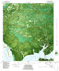
 2024 Southport2024 Print · USGSIn the modern era of Bay County, this area north of Panama City shows a landscape where coastal bayous meet growing residential communities. Researchers can trace local heritage through the Southport Community Cem or explore the winding shores of Alligator Bayou and West Bay.
End of results
Showing maps 1-13 of 13
Top cities near Vicksburg
- Panama City historical maps
- Upper Grand Lagoon historical maps
- Lynn Haven historical maps
- Callaway historical maps
- Panama City Beach historical maps
- Springfield historical maps
See more
Frequently asked questions
- What are the different types of historical maps available for Vicksburg?
- What is the oldest map of Vicksburg?
- Where can I purchase historical maps of Vicksburg for my home or office?
- Where can I download high-res historical maps of Vicksburg?
- Are there historical topographic maps available for Vicksburg?
- Is there historical aerial imagery available for Vicksburg?
- Where are historical maps of Vicksburg sourced from?