1990s Maps of Starke, Florida
Explore 3 historic maps of Starke from the 1990s. These maps offer a rare glimpse into what life looked like during the 1990s — showing old roads, neighborhoods, homes, and landmarks that have changed or disappeared over time.
Whether you're researching your family's past, planning a metal detecting trip, or studying how Starke's landscape evolved across the 1990s, these high-resolution maps are a powerful tool for exploring the history of this region.
- Focus on a specific era: All maps on this page are from the 1990s, giving you a focused view of this time period.
- See what’s changed: Compare century-old streets, trails, and buildings to today's modern landscape using overlays and satellite layers.
- Research with precision: Use these maps for genealogy, historical research, land use analysis, or educational projects.
- View, download, or print: Maps are fully viewable online in high resolution, and can be downloaded or printed for your own records.
Start exploring Starke's history through authentic maps from the 1990s. This is your window into the past.
Starke, FL maps
(3)- 1991 Map of Starke
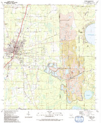 1991 Starke1991 Print · USGSStarke and its surrounding Bradford County rural districts are shown in the early nineties, revealing a mix of municipal growth and heavy industrial extraction. Researchers can locate several community landmarks including the Bethlehem Mem Cem, New Hope Ch, and the extensive Strip Mines near Kingsley Village.
 - 1991 Map of Sampson
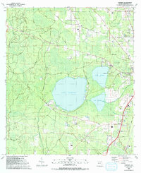 1991 Sampson1991 Print · USGSBradford County’s lake country is surveyed here in the early nineties, centered on the interconnected waters of Lake Sampson and Lake Rowell. Genealogists and local historians can trace legacy sites like Crosby Lake Cem, Lee Cem, and the community of Pleasant Grove.
 - 1999 Map of Starke, 2001 Print
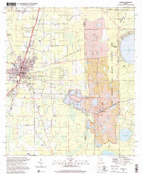 1999 Starke2001 Print · USGSIn the late nineties, the area around Starke was a hub of industrial mining and military training. Researchers can trace local genealogy through numerous rural landmarks like Bethlehem Mem Cem and Morgan Road Ch, or study the footprint of the Trail Ridge Mine.
End of results
Showing maps 1-3 of 3
Top cities near Starke
- Jacksonville historical maps
- Gainesville historical maps
- Lake Butler historical maps
- Keystone Heights historical maps
- Waldo historical maps
- Lawtey historical maps
See more
Frequently asked questions
- What are the different types of historical maps available for Starke?
- What is the oldest map of Starke?
- Where can I purchase historical maps of Starke for my home or office?
- Where can I download high-res historical maps of Starke?
- Are there historical topographic maps available for Starke?
- Is there historical aerial imagery available for Starke?
- Where are historical maps of Starke sourced from?