1950s Maps of Brevard County, Florida
Explore 37 historic maps of Brevard County from the 1950s. These maps offer a rare glimpse into what life looked like during the 1950s — showing old roads, neighborhoods, homes, and landmarks that have changed or disappeared over time.
Whether you're researching your family's past, planning a metal detecting trip, or studying how Brevard County's landscape evolved across the 1950s, these high-resolution maps are a powerful tool for exploring the history of this region.
- Focus on a specific era: All maps on this page are from the 1950s, giving you a focused view of this time period.
- See what’s changed: Compare century-old streets, trails, and buildings to today's modern landscape using overlays and satellite layers.
- Research with precision: Use these maps for genealogy, historical research, land use analysis, or educational projects.
- View, download, or print: Maps are fully viewable online in high resolution, and can be downloaded or printed for your own records.
Start exploring Brevard County's history through authentic maps from the 1950s. This is your window into the past.
Brevard County, FL maps
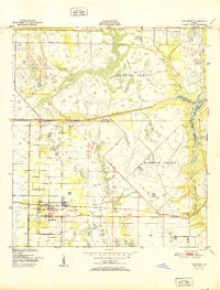
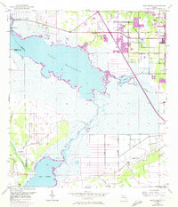
(37)- 1950 Map of Maytown, 1952 Print
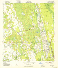 1950 Maytown1952 Print · USGSIn the mid-century Florida marshlands, historical land grants and the railroad define the local landscape. Genealogists and historians can trace the exact boundaries of the Delespine Grant and Peter Fouchard Grant near the settlement of Maytown.6 unique versions available
 - 1950 Map of Aurantia, 1952 Print
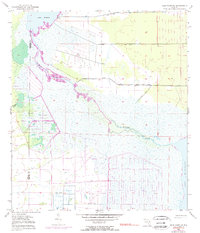
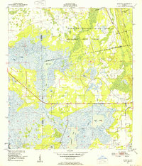 1950 Aurantia1952 Print · USGSBrevard County was a landscape of Spanish land grants and sprawling wetlands at the mid-century point. Researchers can trace the Florida East Coast rail line as it passes through Aurantia, and locate landmarks like Southmere and the Brevard County Game Refuge.5 unique versions available
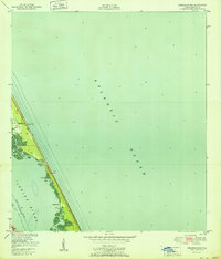
 - 1951 Map of False Cape
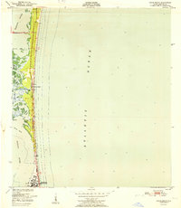
 1951 False Cape1951 Print · USGSThe Atlantic coast and Merritt Island are seen here in the early fifties before the space age transformed the region. Researchers can trace early coastal settlements and landmarks like the Canaveral Club, De Soto Beach, and the wild expanses of the State Game Refuge.
 - 1951 Map of Sebastian NW
 1951 Sebastian NW1951 Print · USGSThe Florida barrier islands south of Melbourne appear in the early fifties as a quiet stretch of coastal road and maritime coves. Trace the early footprints of Evans Pines or find the Lookout Tower and Light used for mid-century navigation.
 - 1951 Map of Melbourne East
 1951 Melbourne East1951 Print · USGSThe Space Coast shoreline comes alive in the early fifties, showing the mainland growth of Melbourne and Eau Gallie before the height of the space race. Trace the early layout of Indialantic, the path of the Florida East Coast rail line, and waterfront landmarks like Wells Park.
 - 1951 Map of Eau Gallie
 1951 Eau Gallie1951 Print · USGSBrevard County's coastline before the height of the space age reveals a landscape of isolated settlements and winding waterways. Genealogists and historians can trace the early footprints of Eau Gallie, the Gleason Cem, and small railroad stops like Pineda.
 - 1951 Map of Fellsmere
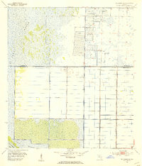
 1951 Fellsmere1951 Print · USGSIndian River County's inland landscape was a mix of canal engineering and citrus-era transport just after the war. Researchers can trace the Trans Florida Central Line, locate the Old Sebastian Cem, and find Brookside.
 - 1951 Map of Cocoa
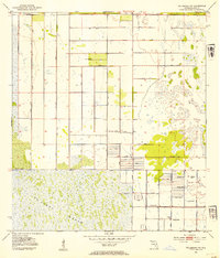
 1951 Cocoa1951 Print · USGSThe Space Coast was just beginning its transformation in the early fifties, with the Indian River separating established towns from the citrus groves of Merritt Island. Researchers can trace the path of the Dixie Highway through Rockledge or locate vanished landmarks like Fairyland and the Cocoa Municipal Airport.
 - 1951 Map of Melbourne West
 1951 Melbourne West1951 Print · USGSBrevard County was entering a new era of growth and aviation during the early fifties, before the space age transformed the region. Researchers can trace the layout of the Malabar Naval Air Station and early neighborhoods like June Park and Eau Gallie.
 - 1951 Map of Courtenay
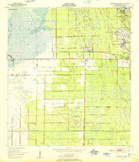
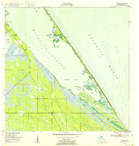
 1951 Courtenay1951 Print · USGSMerritt Island and the adjacent mainland appear in the early fifties, before the nearby space center transformed the local geography. Researchers can trace early community sites like Courtenay, Indianola, and Audubon, alongside landmarks like St Lukes Ch and Bethel Cem.2 unique versions available
 - 1951 Map of Sharpes
 1951 Sharpes1951 Print · USGSIn the early 1950s, the Brevard County coast was defined by riverside settlements and narrow rail corridors. Researchers can trace the Florida East Coast rail line through Sharpes and City Point, or locate the old Cem and Pinkerton Pier (C).
 - 1951 Map of Grant
 1951 Grant1951 Print · USGSCoastal Brevard County comes into focus in the early fifties, showing the interplay of naval aviation and quiet riverfront life. Genealogists and local historians can trace the foundations of Valkaria, the Cemetery near Grant, and the rail stops along the Florida East Coast.
 - 1951 Map of Cocoa Beach
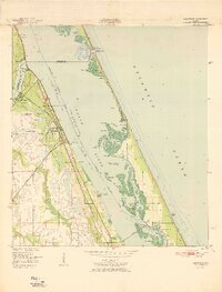
 1951 Cocoa Beach1951 Print · USGSThe Florida coast near Cocoa Beach appears at a turning point in the early fifties, before the height of the space race. Genealogists and historians can trace the early town layout and landmarks like the U S Military Reservation and the Thousand Islands.
 - 1951 Map of Orsino
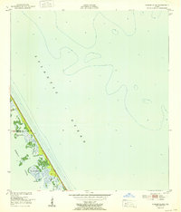
 1951 Orsino1951 Print · USGSMerritt Island in the early fifties remains a labyrinth of coastal wetlands and small fishing outposts. Genealogists and historians can trace the early footprints of Orsino and Hubs Landing or locate landmarks like Picnic Island and Peacocks Pocket.
 - 1951 Map of Cape Canaveral
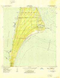 1951 Cape Canaveral1951 Print · USGSCoastal Florida is captured in the early fifties, before the arrival of the space program transformed the landscape. Researchers can trace the old community of Artesia, locate the Cape Canaveral Lighthouse, and explore the bounds of the De Soto Beach State Game Refuge.3 unique versions available
 - 1951 Map of Sebastian
 1951 Sebastian1951 Print · USGSThe Florida shoreline in the mid-century shows a landscape of rail-centered citrus and fishing communities nestled between the lagoon and the sea. Researchers can locate the Sebastian Cem, trace the Florida East Coast tracks, and explore the wetlands of the Pelican Island Bird Sanctuary.
 - 1951 Map of Tropic
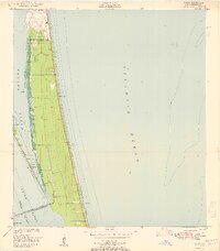 1951 Tropic1951 Print · USGSCoastal Brevard County appears in the early 1950s as a stretch of narrow barrier islands and lagoons dominated by the U S Military Reservation. Researchers can trace old bridges and shoreline landmarks like the Mathers Bridge, Tropic settlement, and Canova Pier.
 - 1952 Map of Mims
 1952 Mims1952 Print · USGSBrevard County's citrus and rail corridor is captured here in the early fifties, where the coastal landscape is still defined by large Spanish-era land grants. Genealogists and historians can trace the early layout of Mims, La Grange, and Allenhurst, or locate the Indian Mound and the strategic Haulover Canal.
 - 1952 Map of Wilson
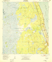
 1952 Wilson1952 Print · USGSThe Florida coast near the Mosquito Lagoon is shown in detail during the early 1950s, before the arrival of the modern space program. Local historians can trace early shoreline settlements and camps like Wilson, Ragin Fish Camp, and Dunmit Grove among the complex marshlands.
 - 1952 Map of Pardon Island
 1952 Pardon Island1952 Print · USGSThe Florida coast near the Volusia and Brevard county line is captured in the early fifties, showing a remote landscape of islands and sloughs. Researchers can trace the early footprints of the Pardon settlement and locate landmarks like Three Cabbage Island and Pardon Slough.
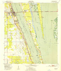
 - 1952 Map of Titusville
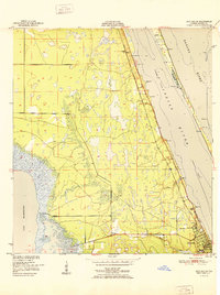
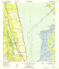
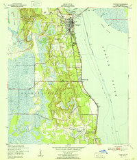 1952 Titusville1952 Print · USGSThe Space Coast was just beginning its modern transformation in the early fifties, with Titusville serving as a vital rail and river hub. Local historians can trace the early layout of Indian River City, the grounds of the County Farm, and the vast Delespine Grant.
 - 1953 Map of Lake Poinsett
 1953 Lake Poinsett1953 Print · USGSBrevard County was a land of transition in the 1950s as modern highways began to bypass the traditional river life of the St. Johns. Genealogists and local historians can trace early outposts like Lone Cabbage Camp, the Trailer Park Cem, and the riverfront Poinsett Lodge.4 unique versions available
 - 1953 Map of Deer Park NE
 1953 Deer Park NE1953 Print · USGSFlorida's inland marshes at the mid-century mark reveal a landscape defined by the winding St Johns River. Genealogists and environmental historians can trace the old county lines and water features like Lake Winder, Pennywash Creek, and early Spoil Banks.5 unique versions available
 - 1953 Map of Fellsmere SW, 1954 Print
 1953 Fellsmere SW1954 Print · USGSThe Florida marshlands during the early 1950s show an environment being actively reshaped by drainage engineering. Trace the early water management systems of St Johns Marsh through its network of Levees, Flowing Wells, and the Trans Florida rail line.3 unique versions available
 - 1953 Map of Fellsmere NW, 1954 Print
 1953 Fellsmere NW1954 Print · USGSBrevard County was undergoing a major transformation in the early 1950s as engineers reshaped the Florida wetlands. Researchers can trace the mid-century hydrological changes through the network of Levee and Spoil Bank systems surrounding St Johns Marsh.3 unique versions available
Showing maps 1-25 of 37
Top cities of Brevard County
- Palm Bay historical maps
- Melbourne historical maps
- Titusville historical maps
- Merritt Island historical maps
- Rockledge historical maps
- West Melbourne historical maps
See more
Frequently asked questions
- What are the different types of historical maps available for Brevard County?
- What is the oldest map of Brevard County?
- Where can I purchase historical maps of Brevard County for my home or office?
- Where can I download high-res historical maps of Brevard County?
- Are there historical topographic maps available for Brevard County?
- Is there historical aerial imagery available for Brevard County?
- Where are historical maps of Brevard County sourced from?