1980s Maps of Brevard County, Florida
Explore 4 historic maps of Brevard County from the 1980s. These maps offer a rare glimpse into what life looked like during the 1980s — showing old roads, neighborhoods, homes, and landmarks that have changed or disappeared over time.
Whether you're researching your family's past, planning a metal detecting trip, or studying how Brevard County's landscape evolved across the 1980s, these high-resolution maps are a powerful tool for exploring the history of this region.
- Focus on a specific era: All maps on this page are from the 1980s, giving you a focused view of this time period.
- See what’s changed: Compare century-old streets, trails, and buildings to today's modern landscape using overlays and satellite layers.
- Research with precision: Use these maps for genealogy, historical research, land use analysis, or educational projects.
- View, download, or print: Maps are fully viewable online in high resolution, and can be downloaded or printed for your own records.
Start exploring Brevard County's history through authentic maps from the 1980s. This is your window into the past.
Brevard County, FL maps
(4)- 1981 Map of Vero Beach, 1982 Print
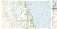 1981 Vero Beach1982 Print · USGSThe Florida Atlantic coast and the upper St. Johns River basin are shown here in the early 1980s during a period of steady coastal growth. Researchers can trace the development of Vero Beach and Palm Bay or locate inland landmarks like Blue Cypress Lake and the Valkaria Missile Tracking Station.
 - 1981 Map of Cape Canaveral, 1983 Print
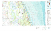
 1981 Cape Canaveral1983 Print · USGSThe Space Coast and the Florida marshlands meet in the early eighties as aerospace technology and nature preserves sit side-by-side. Trace the development of Cocoa Beach, the sprawling grounds of the Kennedy Space Center, and the inland waters of Lake Poinsett.
 - 1985 Map of Vero Beach, 1986 Print
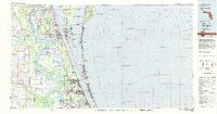
 1985 Vero Beach1986 Print · USGSThe Florida coast and St. Johns River headwaters are captured here in the mid-eighties, from the Atlantic shoreline to the interior marshes. You can trace the Florida East Coast RR through Sebastian or locate the Valkaria Missile Tracking Station near the coast.
 - 1988 Map of Fort Pierce
 1988 Fort Pierce1988 Print · USGSThe Atlantic coast and Florida’s interior lakelands are captured in the late eighties, just as the Treasure Coast was experiencing rapid development. Genealogists and historians can trace the rail lines of the Florida East Coast and explore the bounds of the Brighton Indian Reservation.
End of results
Showing maps 1-4 of 4
Top cities of Brevard County
- Palm Bay historical maps
- Melbourne historical maps
- Titusville historical maps
- Merritt Island historical maps
- Rockledge historical maps
- West Melbourne historical maps
See more
Frequently asked questions
- What are the different types of historical maps available for Brevard County?
- What is the oldest map of Brevard County?
- Where can I purchase historical maps of Brevard County for my home or office?
- Where can I download high-res historical maps of Brevard County?
- Are there historical topographic maps available for Brevard County?
- Is there historical aerial imagery available for Brevard County?
- Where are historical maps of Brevard County sourced from?